The rock formations which you can see along the cliff top trail in Dunbar are a unique combination of continental drift, volcanic activity and erosion from the sea, amongst other things.
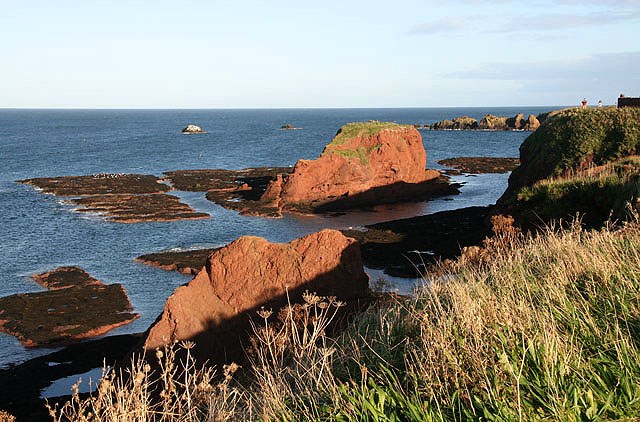
The area in which you should be standing when you visit this cache is Old Red Sandstone. This rock was once part of the Old Red Sandstone Continent (also know as Euroamerica) during the Devonian Period, between 419 and 359 million years ago. During this period, these cliffs were 25 degrees south of the Equator! As a result of the geological movement since then, some of the Old Red Sandstone has ended up here, in Dunbar, surrounded by limestone and basalt rock from a later period (mainly the Carboniferous era). Other examples of Old Red Sandstone in Scotland can be found in the Moray Firth and the Orkney Islands. At the first waypoint, you can see a spectacular example of the way the erosion of wind and waves have exposed the ancient strata in the sandstone rock. Exposed strata are very important for understanding the history of the earth as they allow geologists to see the way the rock was formed thousands of years ago.
After the end of the Devonian Period, continental shift and climate change led to the formation of the limestone and sandstone that surrounds these red sandstone cliffs. During this time, Scotland was moving north and crossing the equator. The Carboniferous era was also the time when there was the most volcanic activity in the Lothians. Along with forming the famous and spectacular geography of the capital, volcanic activity in this area led to deposits of quartz-dolerite in amongst the softer, sedimentary rock in this area. In Dunbar, these can be most clearly seen at Dunbar Castle in the Harbour area, where the octagonal structure is very exposed close to the shore. However, you can also see some of them as you look out to sea.
These deposits of quartz-dolerite also run through the intertidal platforms below the cliffs. These are difficult to see when the tide is high, but if it is low, you will be able to see the rock just below the surface of the sea. This is the lowest of four distinct platforms. The cliffs form the highest platform. You can see the middle platform, which is a glacial raised beach, at the end of the clifftop trail, and now forms part of the Winterfield Golf Course. You can find out more about glacial raised beaches by visiting the Silverknowes Seaside Retreat? EarthCache in Edinburgh.
Along the path that leads by the golf course, you can see the effect the sea has on these ancient cliffs in the form of the “shatter zone”. This is where the rocks which have fallen away from the cliffs are carried to as they are broken down. As rocks are thrown up and dragged back by the tide, the rock is ground away to the red sand that forms the beach. The beach is quite literally being created right before your eyes (albeit very slowly). Take some time to have a look at the rocks in the different stages of breakdown.
Here are the questions you need to log this cache:
First waypoint (N56 0.283, W002 31.300)
1. At the first waypoint, how many different layers of rock can you see in the overhang?
Second Waypoint (N56 0.361, W2 31.732)
2. A quick check to make sure you didn’t just Google the answers - how many holes are there in the stone on the cliff top?
3. Look behind you at the wall, what do you think has caused the very distinctive destruction to the bricks?
4. Out to sea, there are rock stacks which serve to protect the cliffs from the tides. Why do you think these stacks remain, and have not been eroded away?
Third Waypoint (N56 0.274, W2 32.097)
5. Why do you think the shatter zone is at this end of the cliffs? You may want to look at Dunbar on a map to help with this question.
And finally...
6. If you would like to, please post a photo with your log showing what the sea and cliffs are like while you are visiting. You can include yourself and your GPS kit in the photo too, if you like!
Useful and Important Information
- As this is an EarthCache, there is no container. However, you MUST email me your answers before logging the cache. I will do my best to reply as quickly as possible, but you do not need to wait for a reply before posting a find. Logs made before an email with the answers is sent will be deleted, as will logs where no email with answers is sent.
- The whole cache can be completed without entering the golf course. A right of way does exist along the edge of the course, but if you do choose to enter the golf course, you do so at your own risk - please take great care to avoid any flying balls!
- Families - take care with kids doing this cache. It should be absolutely fine, but these are high and steep cliffs so take care
- Disabled cachers - you should be able to log this, but be aware that it is on clifftops and may be difficult for those with mobility problems in bad weather. If you have trouble answering the first question, let me know.
- This cache is accessible by public transport as it's about five minutes from the main central bus stops, and fifteen minutes from the train station. Trains to/from Dunbar run via Berwick Upon Tweed and Edinburgh.