NEDERLANDS
WATAMULA - De adem van Curaçao
Deze Earthcache brengt je, via het dorp Westpunt, naar een bijzondere geologische locatie. Nabij dit dorp loopt een zandweg richting de kust. Via deze hobbelige en onverharde weg kom je uit bij de zee. Onderweg kom je de bordjes ”Watamula” al tegen. Watamula is Papiaments voor watermolen. Papiaments is de taal van ondermeer het eiland Curaçao.
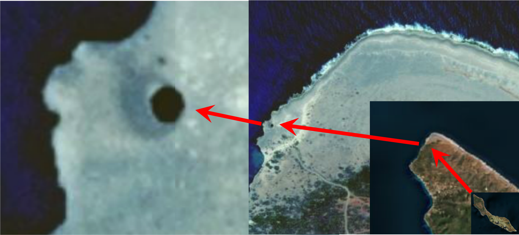
Satelliet-view (C) Google-maps.
Aangekomen bij de kustlijn sta je letterlijk op de westpunt van Curaçao, daar waar de zee erg ruig is. Je voeten rusten nu op een plateau van sedimenten: kalksteen. Het afzettingsgesteente kalksteen wordt gevormd uit een versteende opeenhoping van calciumcarbonaat. Dit klinkt chemisch maar in de praktijk is het ontstaan door de opeenhoping van in zee levende organismen althans de kalkhoudende stoffelijke overblijfselen er van. Het gesteente waar je op staat is sedimentair gesteente uit het pleistoceen. Dit aan de hand van de meest recente geologische kaarten van Curaçao alsmede aan de hand van informatie van een lokale stichting welke een bijdrage levert aan de duurzame ontwikkeling en management van de natuurlijk hulpbronnen op Curaçao door wetenschappelijk onderzoek, natuurbeheer en natuur en milieu educatie.
Nabij Waypoint 1 zie je een gapend gat in het gesteente. Door dit gat stroomt het krachtige en kolkende zeewater dat via kanalen in de rotsbodem door de zee daar naar toe wordt gedrukt. Het krachtenspel van de zee zorgt er voor dat het water hevig omhoog wordt geduwd. Daar waar het tegen het gesteente duwt zoekt het de weg van minste weerstand en spuwt de zee het water door het gat naar boven. Bij Watamula zelf is dit wel krachtig maar spuit het niet met kracht meters hoog.
Loop nu door naar Waypoint 2. Dit is een echte ‘spuiter’! Zelfs als de zee rustig is spuit hier het water al meters omhoog. Let op dat de wandeling naar dit waypoint niet zonder risico is. Het gesteente is scherp. Draag goed schoeisel en zorg dat je niet ten val komt. Deze hele trip naar Watamula en haar omgeving is voor eigen risico.
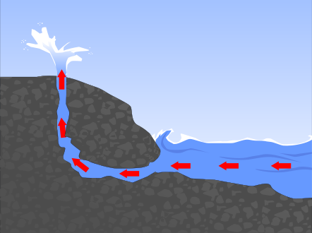
Grafische weergave van de beweging van het zeewater bij waypoint 2.
Het mag duidelijk zijn dat je bent aangekomen bij een blowhole, ook wel spuit- of blaasgat genoemd. Blowhole is een engelstalige benaming. Het spuit- of blaastgat is de geologische term voor een waterfontein. Een dergelijk waterfontein ontstaat doordat golven door de mond cq opening van een grot of inham met kracht omhoog getrechterd worden. Blaasgaten zijn bijzonder spectaculaire natuurverschijnselen. De lokale bevolking dacht hier ook zo over en heeft deze omgeving dan ook een bijzondere beschrijving gegeven:
‘De adem van Curaçao’. En inderdaad, ervaar letterlijk de adem van de Aarde! Zelfs als de zee hier rustig is, wat zelden het geval is, kun je de adem horen. Waypoint 3 is zo’n plek. Luister zelf met je oor aan de grond en hoor Curaçao ademen. 
Technisch gezien zijn er vier hoofdprocessen die kunnen leiden tot de vorming van een blowhole.
Hydraulische werking: De kracht van de golven comprimeert luchtzakken in kleine scheuren in de rots. Als het water weer wegtrekt zetten de gecomprimeerde luchtzakken, welke onder hoge druk staan zeer snel uit. Het gesteente wordt op deze wijze steeds gekraakt om uiteindelijk te breken.
Schuring: Golven beuken tegen de rots. De beukende golven dragen rotsdelen, kiezels, zand, etc. en schuurt daarmee door en tegen de klif/spleten.
Chemische verwering: Het gesteente, en dan met name kalksteen (welke grotendeels is samengesteld uit calcium-carbonaat), wordt opgelost door zuren in het zeewater.
Wrijving: Golfwerking veroorzaakt dat los gesteente en puin met elkaar botsen. Dit resulteert in kleinere en rondere deeltjes, die op hun beurt een schurendeffect op de rest van de rots hebben.
Er zijn overigens met name twee transporterende krachten op deze specifieke locatie:
Water: het verschil tussen eb en vloed is overigens minder dan 0.5 meter bij een constante stroming rondom Westpunt.
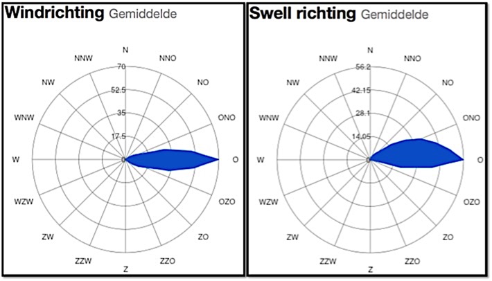
Wind: gedurende het gehele jaar staat er voortdurend een windstroom uit een en dezelfde richting.
LOGVOORWAARDEN
VRAAG 1
Hier boven heb je gelezen de technische vorming van blowholes. Welk hoofdproces of -processen werken respectievelijk aan de vorming van de verschijnselen bij Waypoint 1 en Waypoint 2? Motiveer svp je antwoord.
VRAAG 2
Geef een hypothese hoe Watamula er uiteindelijk zal gaan uitzien en waarom je dat denk? (hoe de structuur/vorm zal veranderen in de toekomst)
E-mail svp je antwoorden door via mijn geocaching.com profiel onder vermelding van de naam van deze Earthcache. Voel je vrij om na je bezoek aan deze Earthcache deze direct te loggen voordat je een bevestiging van mij ontvangen hebt. Echter als ik niets heb ontvangen binnen een redelijk termijn wordt je log verwijderd.
ENGLISH
WATAMULA – The breath of Curaçao
This Eartchcache brings you, through the village of Westpunt (translated: West point), to a special geological location. A dirt track close to this village runs to the coast. The bumpy and unpaved road brings you to the sea. On the way you already encounter the signs “Watamula”. Watamula is Papiamento and means water mill. Papiamento is the language of the island of Curaçao, among others.
Satelliet-view (C) Google-maps.
Once arrived at the shoreline, you are literally at the West point of Curaçao, where the sea is very rough. Your feet are now resting on a plateau of sediments: limestone. The sedimentary rock limestone is formed from a fossilized conglomeration of calcium carbonate. This sounds chemical, but in practice it is formed by the accumulation of organisms living in the sea, well, at least the calcareous material remains of them. The rock you are standing on is sedimentary rock from the pleistocene. This is based on the most recent geological maps of Curaçao and information from the local foundation which contributes to a sustainable development and management of natural resources on Curaçao by scientific research, nature management and nature and environment education.
Close to Waypoint 1 you will find a gaping hole in the rock. The powerful and swirling seawater, which is forced up by the sea through channels at the base of the rock, is flowing through this hole. The power of the sea causes the water to be pushed up violently. Where the water is pushed against the rocks, it seeks the path of least resistance and in this way the sea spits the water upwards through the hole. At Watamula itself it is very powerful, but it doesn’t blow meters high.
Now walk to Waypoint 2. This is a real ‘gusher’! Even when the sea is calm, the water squirts meters up already. Please note that the walk to this waypoint is not without any risk. The rocks can be sharp. Wear protective footwear and make sure not to fall. The whole trip to Watamula and the surroundings is at your own risk.
Graphical overview of the seawater movement at waypoint 2.
It is clear that you arrived at a blowhole. Blowhole is a geological term for water fountain. Such a water fountain arises because waves are pushed through the mouth or hole of a cave or inlet and forced violently upwards through a tunnel. Blowholes are spectacular natural phenomena. The locals thought the same about this and gave this area a special name:
‘The breath of Curaçao’. And indeed, experience literally the breath of the Earth! Even if the sea is calm, which is rarely the case here, you can hear the breath. Waypoint 3 is such a place. Listen with your ear on the ground and you can hear Curaçao breath.
Technically there are four main processes that can lead to the formation of a blowhole.
Hydraulic action: The force of the waves compresses pockets of air in small cracks in the rock. When the water moves out the compressed air expands quickly. The rock is slowly crunched until it finally breaks off completely.
Sanding down: Waves hit the rocks continuously. The waves carry rock particles, pebbles, sand, etc. that sand down the rock and scrape through the cracks.
Chemical erosion: The rock, and especially the limestone (which mainly consists of calcium carbonate), is dissolved by acids in the water.
Friction: The waves cause loose rocks and debris to collide. This results in smaller and rounder particles, which in their turn cause the sanding down of the rock.
There are mainly two transporting forces at this specific location:
Water: The difference between the tides is less than 0.5 meter with a constant flow around Westpunt.
Wind: During the entire year there is a continuous wind flow from the same direction..
wind direction | swell direction
LOGGING REQUIREMENTS
QUESTION 1
Above you have read the technical processes of the formation of blowholes. Which main process or processes are involved in the origin of the phenomena at respectively waypoint 1 and waypoint 2? Please elaborate.
QUESTION 2
Give a hypothesis about how Watamula will finally look like. Why do you think so? (How will the structure/form change in the future)
Please email your answers through my geocaching profile quoting the name of this Earthcache. Feel free to log the Earthcache immediately after your visit, even before you receive my confirmation. When I don’t receive anything within reasonable time, your log will be deleted.