This EarthCache is one of several in an EarthCache Trail that runs along the Missouri River from the Chouteau County Fairgrounds Campground and Canoe Launch (Fort Benton - RM 0) to Coal Banks Landing (RM 41.5). This EarthCache is only accessible from the river. For more information and the first EarthCache in this series, please see the following link: click here.
For the next EarthCache in the trail, click here.
There is also a series of EarthCaches for the middle section of the river, from Coal Banks to Judith landing and for the lower section of the river, from Judith to Kipp Recreation Area. For this middle section EarthCache trail, click here.
For this lower section EarthCache trail, click here.
----------------------
The River’s Pulse
The Earthcache before this one introduced you to the erosional aspects of the river. This Earthcache will look more in-depth into the natural flow of the Upper Missouri River and how it has changed over time. The Missouri river runs over 2,000 miles from its headwaters at Three Forks, Montana to where it meets with the Mississippi River in St. Louis, Missouri. It is the longest river in the United States. When taking into account its length with the Mississippi River included, it is the third longest river in the world. It is nicknamed ‘Big Muddy’ or ‘Muddy Mo’ due to the high content of silt carried in the water, making it look brown or muddy. Elevation of the river is 4,045ft at its headwaters and 400ft at its confluence (junction where it drains into another river) with the Mississippi River. It drains nearly one sixth of the North American continent!! Controlled now throughout most of the river by dams and reservoirs, there are typically two peak flows for the Missouri each year: once in March when snowmelt from the plains and breakup of ice causes river levels to rise, then again in June when snowmelt from the Rockies and rain causes river levels to rise.
![]() The many facets of a river system (GeographyPods.com)
The many facets of a river system (GeographyPods.com)
Rivers soften and remove surface material in the process called erosion. Two agents of river erosion are transport and deposition. Transport is when a river moves its erosional products downstream. Below lists the four ways a river transports its sediment.
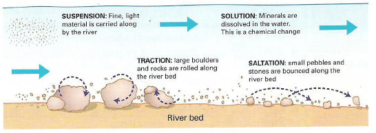 Methods of river transport (GeographyPods.com)
Additionally, there are three classifications of sediment load a river transports. Solution refers to the dissolved load of a waterway. The suspended load consists of fine-grained particles held aloft, with the finest particles held in suspension until the river speed slows. Bed load refers to larger materials that are rolled along the stream bed by traction or are dragged along by saltation. If the load in a river is larger than its capacity then aggradation occurs. Aggradation is the buildup of excess sediment as deposition fills the stream channel. Deposition is simply the act of sediment load being placed after transport.
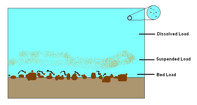 Different types of sediment load (Wikipedia)
These types of transport and deposition shape the river channel. The common shapes a river can form are meandering, braided, wandering, or straight. A meander forms when a river erodes the outer banks and widens its valley, while the inner part of the river deposits sediment. A meandering river takes on a snake-like form. A braided river forms a network of several branching and reuniting channels separated by bars. These generally form where there is very high sediment load in relation to the water capacity. A wandering river classification can be applied to rivers which are halfway between meandering and braided; they have both characteristics. A straight channel is just as it sounds. Most of the Missouri River is classified as meandering. Below is a very informative graphic on the topics you’ve just learned about river processes, and many more.
 In-depth look at river processes (Chris Read - Mind Mapping)
There is another deciding factor in the natural pulse of the Missouri River: glaciers. A glacier is a slow moving ‘river’ of ice that accumulates from snowfall on mountains. Glaciers that have affected the surface features in this area date back to the Quaternary Glacial Cycles. Quaternary is a period of time on the geologic timescale and is dated at 2.5 million years ago to the present. Glacial cycles are alternating periods of cold and glaciation followed by warming. There were numerous glaciations during this time period and are classified as (from oldest to most recent): Pre-Illinoian (680,000-200,000 years ago), Illinoian (200,000-130,000), and Wisconsin (130,000-12,000). Glaciations have changed the Missouri River’s course dramatically due to the channel being blocked by ice from time to time in the geologic past. Prior to glaciation the Missouri River ran north of its current channel near modern-day river mile 47 (Little Sandy Creek) and emptied into the Hudson Bay, instead of south to the Gulf of Mexico like it does now. The Milk River, as it runs today, was actually the old channel for the Missouri. Later glaciation blocked its route and moved it to its current southern position. This fact is evident in the understanding of the way a river valley matures. If erosion is consistent throughout a younger valley (narrower) should be less eroded than an older valley (wider).
 Course of preglacial Missouri River between current Missouri River and Milk River. Heavy black lines show width of preglacial river valley. (From Alden, 1932)
When a glacier advances it can cover a huge area (hundreds and hundreds of miles) and can be very thick (many miles thick). This can bring great geological disruption to the area it covers. In the case of the Missouri River numerous glaciations in the last million years have changed its course. Take a look at the four figures below to get an idea how the river channel has shifted during glaciations.
 Preglacial drainage pattern in northern Montana (From Alden, 1932)
 Drainage pattern in northern Montana at height of Illinoian or Iowan (?) glacial advance. Preglacial drainage pattern indicated in dashed lines (From Alden, 1932)
 Drainage pattern in northern Montana during early Wisconsinan stage (From Alden, 1932)
 Postglacial drainage pattern in northern Montana. Sections of preglacial drainage pattern indicated in dashed lines (From Alden, 1932)
Today the landscape here is evidence of the changes that took place during glacial cycles. The change of river course around river mile 47, abandoned river channels (Milk River, Shonkin Sag), narrow versus broad valleys, and igneous rocks plucked from the source and transported by ice all indicate this was glaciated terrain. Use your knowledge of glaciers to pick out other features of glaciated terrain as you float downriver.
To claim this cache: Answer the following question and send the answers using Geocache's messaging tool.
Q: What two tributaries (a river or stream flowing into a larger river or lake) are present at the junction you are near?
Q: What depositional river feature is present here?