This EarthCache is the first in an EarthCache Trail running from the Chouteau County Fairgrounds Campground and Canoe Launch (Fort Benton - RM 0) to Coal Banks Landing (RM 41.5). RM is ‘River Mile’. Only this first cache is reachable by car—the remainder can ONLY be accessed from the river, and are intended for those floating the Upper Missouri who are looking for a fun and educational geology-scavenger hunt adventure. This 41.5 mile stretch, which typically requires three days and two nights to float in a canoe or kayak, is located within the Upper Missouri River Breaks National Monument/Wild and Scenic River. The Wild and Scenic designation is 149 miles long, from Fort Benton down to Kipp Recreation Area. This entire section of the Missouri is a Class I river, with no significant or dangerous rapids. However, the rest of the EarthCaches in the trail have a 5-star difficulty because the float requires special equipment (boat, tent, stove, etc.), camping experience and planning ahead. Otherwise, once on the river the EarthCaches in this trail are very doable and accessible. Children can certainly come along.
As you travel down the Wild and Scenic Upper Missouri, you will have the opportunity to view firsthand the last undammed portion of this great river, which features outstanding scenery, fascinating geology, and unique plants and animals. The Upper Missouri River Breaks National Monument plays host to a rich cultural history, including Lewis and Clark campsites, Native American heritage areas, old fur trade posts, steamboat landings, and homestead sites. For more information on planning a float down the river, please call the Missouri Breaks Interpretive Center (406-622-4000) or visit the BLM website.
For the next EarthCache in the trail, click here.
There is also a series of EarthCaches for the lower section of the river, from Judith to Kipp Recreation Area and for the middle section of the river, from Coal Banks to Judith landing. For this lower section EarthCache trail, click here.
For this middle section EarthCache trail, click here.
----------------------
Glacial Deposits – Signal Point
As you approach the coordinates of this EarthCache there is no need to leave your river vessel. Sit back and enjoy your very first EarthCache in the geologic history of the Upper Missouri River! As you float past the boat launch, look to the light-colored hill on the left. This is Signal Point.
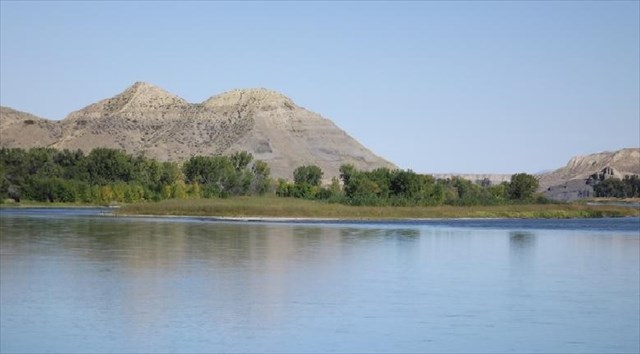 Signal Point, as seen from the Fort Benton Walking Bridge (Fort Benton Realty)
The light-colored material you see on Signal Point is a variety of what geologist’s call glacial till and was deposited during multiple ice ages, which are periods in geologic history when much of the Earth’s land was covered in glaciers. Glacial till is a mixture of sand, silt, and clay that was carried and deposited in a glacier from elsewhere. It can also be local sediment ground up by an advancing or withdrawing glacier. Glaciers are frozen, giant, slow-moving ‘rivers’ of ice that can become extremely large (covering entire continents, for example) and heavy, therefore enabling large boulders to be pulverized and/or carried long distances. You will most likely see glacial till capping the bluffs on either side of the river your entire float. Additionally in glacial till you could find rocks as big as pebbles, cobbles, and even boulders. The unsorted condition these are placed in is usually indicative of glaciation; rivers generally sort rocks depending on size, as you will learn later down the river. From largest to smallest; boulders, cobbles, pebbles, sand, silt, and clay are all geologic terms for grain sizes.
Because in the geologic past glaciers have covered this part of the continent you will see much evidence of these glaciations in the area. Cobbles and boulders you may see along the riverbanks are referred to as glacial erratics. Glacial erratics are rocks (from pebbles to very large boulders) different in composition from the surrounding rock that were transported very long distances by glaciers and deposited where the glacier melts and recedes. These erratics help scientists determine glacial movement. Common erratics in this area are igneous and metamorphic granites, gneisses, and quartzites brought down from Canada by glaciers. This process is referred to as plucking.
The glacial deposits you see on Signal Point were accumulated during Quaternary Glacial Cycles. Quaternary is a period of time on the geologic timescale and is dated at 2.5 million years ago to the present. There were numerous glaciations during this time period and are classified as (from oldest to most recent): Pre-Illinoian (680,000-200,000 years ago), Illinoian (200,000-130,000), and Wisconsin (130,000-12,000). Glacial tills deposited during the Quaternary in this area are pale yellowish-brown, light olive-gray, and brownish-gray in color. They are unstratified (not arranged in layers) and unsorted mixtures of clay, silt, and sand with some pebbles, cobbles, and boulders. Interglacial alluvial deposits within the Quaternary are brownish-gray and composed of gravel, sand, and silt. Interglacial alluvial deposits are sediments deposited by way of water (rivers, streams, etc.) during a period between glaciations. Clasts (fragments of pre-existing minerals or rocks) in these alluvial deposits are composed of igneous rock from the Highwood Mountains, just south of Fort Benton. Glacial lake deposits here are alternating layers of grayish-brown to pale orange silt and very fine-grained sand and clay. Glacial lake deposits are created when a glacier blocks a drainage system. Land over which the glacier moves is grated and eroded, leaving basins. These basins fill with water to become lakes and, eventually, leave layers of sediment behind.
 Quaternary glacial lakes (speckled pattern) in Montana (From Lemke et al, 1965)
An interesting variety of glacial till deposited during the Quaternary is called loess. Loess deposits are highly porous sediments formed by the accumulation of wind-blown silt. Loess can originate from glacial till deposited by wind or it can originate from non-glacial sources such as deserts, dunes, playas, or volcanic ash deposits. Some loess develops into very fertile soil. There appears to be outcroppings of loess in places throughout the Upper Missouri River Valley, but here at Signal Point none seems present.
To claim this cache: Answer the following questions and send the answers using Geocache's messaging tool.
Q: How many different types of deposits do you see in Signal Point? (HINT: Look for color change in deposits.)