The easiest way to show your progress is with Project Geocaching. Project Geocaching Challenges, although you do need to have a membership with them to use the tool. Go to project-GC and use the GC number for this cache to find the checker.
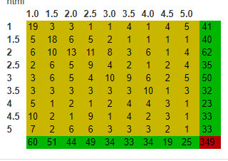
Here is my grid

You have to fill the grid, but you can't use Traditionals. And you can't use Puzzles/Unknowns. Everything else goes, date doesn't matter. Good luck. While the original Fizzy challenge is one of the few challenges that can get harder with each passing year, I have a feeling that this one will get easier over time.
The cache is a Duct Taped preform hanging in a large Manzanita. The Large Manzanita comes up on the left side of the trail (heading down). Climb up above the slope past the Manzanita, and follow the one branch going uphill until it comes back to a level you can reach. The preform is hanging there. Its about 15 feet to the left of the path, hanging about chest high.
This Ridge trail, sometimes referred to as the 'bacon trail' or 'pigs trail', parallels the fire road. Many bike riders ride up from Aptos, up the fire road and down the trail. The trail says 'no bikes'. But I only saw bikers, I've never seen any hikers there, except for groups that I've led returning from the creek expeditions.
You can sign this early if you want, but before you claim your smiley, show me your finds, and list them or show them on a grid. If you use a grid, use the GC number so that anyone could check and know which ones you are claiming for credit.
You can check the trail head coordinates I used. You can also hike up this trail from Aptos like I did, but I don't think most people will.