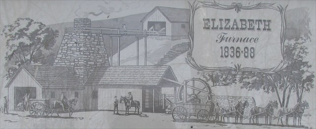
Elizabeth Furnace EarthCache
-
Difficulty:
-

-
Terrain:
-

Size:  (other)
Related Web Page
Please note Use of geocaching.com services is subject to the terms and conditions
in our disclaimer.
This Earthcache is located in the Elizabeth Furnace Recreation Area along the .25 mile loop "Pig Iron Interpretive Trail". There is no physical container nor log to sign, instead there are a series of activities and questions to be answered regarding the site. The area is named for Elizabeth Furnace, a nineteenth century iron blast furnace, the structure of which is still visible and the topic of the interpretive trail established by the George Washington National Forest.
This Earthcache focuses on the artifacts of the furnace operations which may be confused with natural geological formations. There are eight known similar sites in the Massanuten area alone, and even more can be found as you travel up and down the Shenandoah area of Western Virginia and the National Forest.
Activities and Questions
The following is presented first to aid paperless cachers. All information required to answer these questions can be found along the trail and via observations (reading the informational signs at the listed coordinates, which are also entered as waypoints, will also help significantly). But additional information about the area can be found lower on the page. Please stick to the trail and do not disturb the historical artifacts.
- Water
- At N 38° 55.728 W 078° 19.644 (Waypoint WATER1) there is an information sign. Read this and proceed to N 38° 55.738 W 078° 19.596 (Waypoint WATER2). The signs are at opposite ends along the front (downhill) side of the furnace and both discuss water and its importance and use at the furnace. While walking between the two, observe the area between the furnace and the nearby Passage stream.
- Question: Did you see any evidence (or not) of water being diverted from the stream? Describe what you saw and why this might be.
- Large Object
- Find the large object located at N 38° 55.731 W 078° 19.637 (Waypoint BIGOBJ). It is on the ground in front of the fence, and the trail curves around it. Attempt to identify the object and how it might have formed (feel free to use objects from your backpack and interact with it, nearby signs may also shed some light).
- Question: What do you think the object is and how might it have formed? How and why did you come to these conclusions?
- Slag
- Read the informational sign located at N 38° 55.735 W 078° 19.627 (Waypoint SLAG).
- Question: Did you see any evidence of remains of slag on your hike, or in your visit to the area? Why (or why not) do you think this may be? According to the sign, what was one use for slag?
- Mounds
- Proceed to N 38° 55.715 W 078° 19.610 (Waypoint MOUNDS). Observe the mounds and depressions around you (please stay on the trail while doing so).
- Question: What do you think the mounds around this area are remnants of or were used for?
- Optional Photograph
- While certainly not required, a photo taken while visiting is hugely appreciated. Thanks!
Please send the answers to the above questions to me (the Cache Owner, derektiffany) via the "send message" functionality on my profile page. Found logs for which no message is received are subject to deletion.
Additional Information
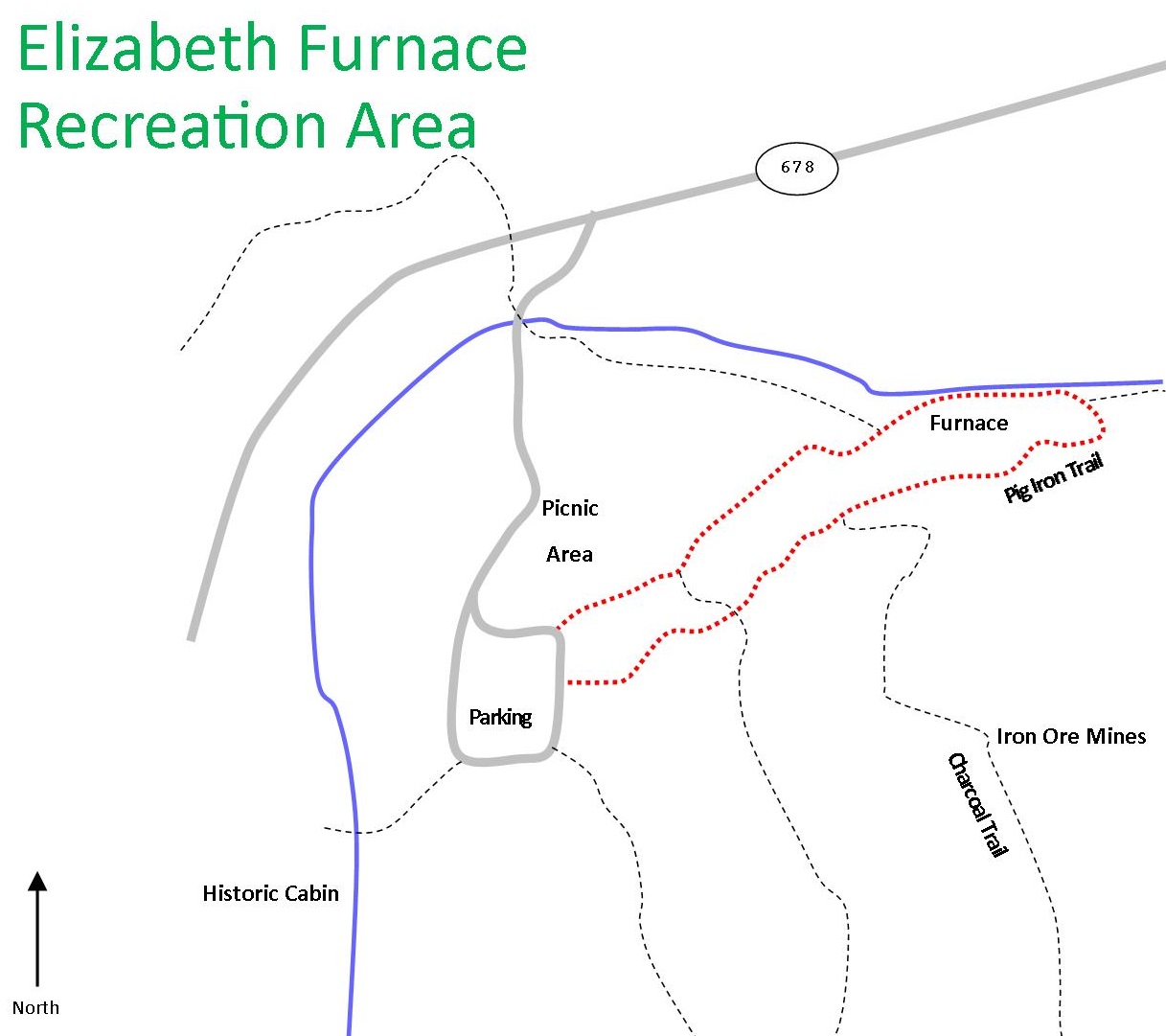
The interpretive trail is approximately .25 miles and can be accessed from the given parking coordinates. The trail forms a loop and can be followed clockwise or counterclockwise. It is recommended to proceed towards posted coordinates from the given trail-head waypoint in the Northeast corner of the parking lot and follow the trail clockwise which will then end in the middle of the Eastern side of the parking lot. The questions progress logically if taking this route. If doing the reverse (following the trail counterclockwise from the middle of the Eastern side of the parking lot), it is recommended to read questions #1 and #3 in advance and think about them throughout your entire walk.
Please stick to the established trail. It will pass all given waypoints. There is some information to be found below and in front of the furnace, and above and behind it. The trail will loop between these locations. Please do not go off-trail or disturb the historical artifacts. And finally, please do not remove or take anything with you from the park (except for obvious trash and litter of course). Thank you.
The interpretive trail provides many details of Elizabeth Furnace specifically and in general about the similar sites in the area which were mostly built and in operation during the pre-Civil War nineteenth century. However, some information not provided along the trail is presented below for additional reading if desired. None of the information below is required to complete the questions above.
 Iron ore deposits have been found along the Eastern border of the area identified as the Central Appalachian Basin above. Map developed by L.S. Ficher, James Madison University
Geology
The ore which was the source of the Virginia Iron industry seems to have been deposited during the later Silurian about 420 million years ago (give or take a few million years of course). During this time, the remnants of the Taconic Orogeny (mountain building) to the East were mostly peneplained (eroded flat) and the Central Appalachian Basin (a large inland basin or sea, depending on ocean levels) had formed to the West. The exact Eastern extent of this basin and specific conditions under which the iron was deposited is unfortunately a little muddied and unknown due to the later dramatic changes which occurred when Gondwana (Africa) collided with eastern North America during the Alleghanian orogeny 300 million years ago significantly altering the Virginia landscape. The iron pooled and concentrated in a narrow region running Northeast to Southwest, but whether this occurred just off the coast of an ancient shore, or in meandering river deltas just a bit further inland appears to be a bit of a mystery.
Chemistry
In addition to iron ore, the other major geological necessity for iron furnaces in the area at the time was limestone which was added as flux to remove impurities. The heat of the furnace caused limestone (calcium carbonate, CaCO3) to decompose to calcium oxide (quicklime) and carbon dioxide.
|
Heat |
|
|
|
| calcium carbonate |
→ |
calcium oxide |
+ |
carbon dioxide |
| CaCO3(s) |
→ |
CaO(s) |
+ |
CO2(g) |
The rock and sand impurities in the ore were silicon dioxide which reacted with calcium oxide to form silicate (slag). The slag was liquid at furnace temperatures and flowed to the bottom where it floated on top of the liquid iron for easy removal.
| calcium oxide |
+ |
silicon dioxide |
→ |
calcium silicate |
| CaO(s) |
+ |
SiO2(s) |
→ |
CaSiO33(l) |
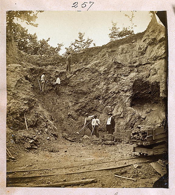 Men work ore banks near Elizabeth Furnace - 1872
History
A full treatment of the historic, economic, and social aspects of Elizabeth Furnace and the pig iron industry in Virginia, while interesting, is unfortunately beyond the scope of this Earthcache. However, some items I found of interest while researching include:
- The furnace was built in 1836 and originally known as "Fort Furnace" due to its location at the entrance of Fort Valley.
- Iron from Elizabeth Furnace was used to supply the Confederate war effort and Tredegar Iron Works during the Civil War.
- While the exact details are unknown, at some point after the Battle of Cedar Creek in 1864 the furnace was damaged and rendered inoperable, presumably by Union troops.
- There were multiple attempts after the war to resume operations, but none proved economically viable.
- The dimensions of the furnace are typical of others in the area. Specifically, the use of wood charcoal (which crushes easily) limited height of the local furnaces to approximately 35 feet.
- Later blast furnaces which used coal largely rendered the earlier charcoal based ones obsolete.
Area
The Elizabeth Furnace Recreation Area was constructed by the CCC (Civilian Conservation Corps) beginning in 1936. It is now part of the George Washington National Forest. The gate is open 8 a.m. to 9 p.m with the day use area open 8 a.m. to Sunset. There are camp sites available, as well as picnic areas and other facilities. Please be aware, however, that there are seasonal differences in amenities.
The area serves as both a family-friendly day-use destination, as well as a starting point for longer hikes and other more strenuous exploration.
The nearby "Charcoal Trail" examines additional aspects of iron furnaces at the time. There are remains of a site where ore was mined along this trail.
 Sources
The following were referenced while researching this page:
Melson, W. G. (2004). Geology explained: Virginia's Fort Valley and Massanutten Mountains (2004 ed.). Fort Valley, Va.: InterPress, U.S.A..
Rader, E. K., & Biggs, T. H. (1976). Geology of the Strasburg and Toms Brook Quadrangles, Virginia. Charlottesville: Virginia Division of Mineral Resources.
Fichter, L. (1999, January 1). Geological Evolution of Virginia and the Mid-Atlantic Region. Geological Evolution of Virginia and the Mid-Atlantic Region. Retrieved July 14, 2014, from http://csmres.jmu.edu/geollab/vageol/vahist/index.html
Molloy, J. (2014)Hiking through history Virginia: exploring the Old Dominion's past by trail. Globe Pequot
Pig Iron Interpretive Trail. Interpretive Signs. Created by the George Washington National Forest, Elizabeth Furnace Recreation Area.

Additional Hints
(Decrypt)
[Included in case you find yourself at GZ without full description or cache page: Start at the Trailhead waypoint, proceed to posted coordinates and follow the trail clockwise around the furnace. Read the signs, observe the area, and you should be able to answer: 1.) Water - Did you see any evidence (or not) of water being diverted from the stream? Describe what you saw and why this might be. 2.) Large Object (posted coords) - What do you think the object is and how might it have formed? How and why did you come to these conclusions? 3.) Slag - Did you see any evidence of remains of slag on your hike, or in your visit to the area? Why (or why not) do you think this may be? According to the sign, what was one use for slag? 4.) Mounds (above furnace) - What do you think the mounds around this area are remnants of or were used for?]