
 Dirt parking is located off Highway 1. The location is provided by a traditional geocache. The path down to the beach is a narrow and sometimes steep dirt path. Expect to have company, though not a lot.
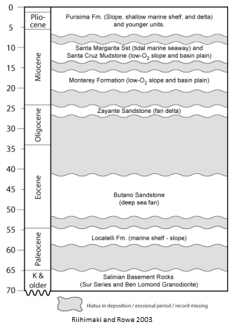 The rocks in this area are a series of formations that where deposited during the Miocene (23.8 to 5.3 million years ago). The oldest of these is the Monterey Formation. On top of that, the Santa Margarita Sandstone was deposited, followed by the Santa Cruz Mudstone. The Monterey Formation and Santa Cruz Mudstone are deep marine silt and mud deposits that are often right next to each other. I have found the Monterey Formation to be a medium gray with easily identifiable layering while the Santa Cruz Mudstone is a dark gray with less identifiable layering.
In a few area the Santa Margarita Sandstone, a coarse, coastal sand separates these two layers of rock. It is often tan with abundant rust and black staining. The layers within the sandstone have easily identifiable crossbeds. The Santa Margarita Sandstone may represent a coastal channel similar to the mouth of the Golden Gate. After these three sedimentary layers were deposited, they were further buried by the Purisma Formation in the Pliocene.
With the added pressure from above, the still saturated Santa Margarita Sandstone was squeezed up through cracks in the Santa Cruz Mudstone, in a process similar to pushing your hand down on the wet beach sand and having the sand ooze up between your fingers. In this way, the sand move up forming sandstone dikes and outward between layers in the Santa Cruz Mudstone forming sills.
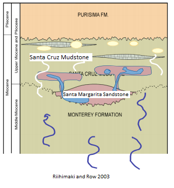 In addition to the water, oils and gas moved through all three layers. In the Santa Margarita Sandstone, it stained areas black as it migrated up through the formation. The gasses probably interacted with seawater precipitating out carbonates at cold seeps (See The Toilet Bowls - Miocene Cold Seeps).
In more recent time, fresh groundwater stained the areas of sand not covered in oil with iron oxide.
Logging requirements:
Send me a note with :
- The text "GC58471 Sandstone Intrusions at Panther Beach" on the first line
- The number of people in your group (put in the log as well).
- Examine the cliff to the east and determine how the sand was moving through the mudstone?
- Look above the arch and determine how the sand was moving through the mudstone?
- Compare the relative amount of staining caused by the migration of oils verses groundwater?
- Can you determine how far into the mudstone the sandstone intruded?
The following sources were used to generate this cache:
- PALEOSURF: The Ancient Beaches of Santa Cruz. Christie Rowe & Catherine Riihimaki. Hellatite Field Outing / February 1, 2003. http://www.es.ucsc.edu/~geoclub/PALEOSURF.pdf
- The Geology from Santa Cruz to Point Ano Nuevo- The San Gregorio Fault Zone and Pleistocene Marine Terraces. Gerald E. Weber and Alan O Alwardt. In Geology and Natural History of the San Francisco Bay Area: A 2001 NAGT Field-Trip Guidebook.