Niesen-Rundwanderung
Allgemeines
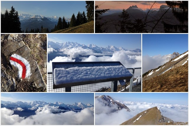
Diese Wanderung führt von der Mittelstation "Schwandegg, 1666m" der Niesenbahn hinauf auf den Gipfel des Niesen, 2362m, und anschliessend über die Alp Oberniese wieder zurück zur Mittelstation. Es werden 700 Höhenmeter im Auf- und Abstieg zurückgelegt.
Auf der SAC-Wanderskala bewerte ich die Route mit T2.
Zeitbedarf
Wer es gemütlich nimmt, rechnet mit ca. 5 Stunden.
Caches unterwegs
Den Startpunkt des Multis erreichst du entweder zu Fuss ab Mülenen in ca. 2.5 Stunden (auf dem Diretissima-Multi), oder bequemer mit der Niesenbahn. Wer "nur" diesen Wandermulti absolvieren will, kann ein Retourbillet lösen Mülenen-Schwandegg-Mülenen.
Start 46° 38.637 - 007° 39.787
= A Das Bergwegzeichen ist:
- aufgemalt auf einem Stein (4)
- aufgemalt an einem dicken Baumstamm (6)
- angenagelt an einen Baumstrunk (8)
- angenagelt an eine Eisenstange (2)
Station 1 46° 38.660 - 007° 39.575
= B In Stein gemeisselt: Wandle den ersten Buchstaben des Nachnamens um nach A1 / Z26.
Übrigens: Wenn du ab hier den schmalen Pfad auf gleicher Höhe nur eine Minute weiterläufst, stehst du auf einem sensationellen Aussichtspunkt! Es lohnt sich total!
Station 2 46° 38.722 - 007° 39.281
= C Hier siehst du:
- Holzbank zum Ausruhen (0)
- Metall-Zaundurchgang (2)
- grosser Steinmann (4)
- Bergwegzeichen auf Steinmauer(7)
Station 3 46° 38.747 - 007° 38.443
= D Vom Wort direkt oberhalb "Oey" wandelst du den ersten Buchstaben um nach A1/Z26.
Station 4 46° 38.383 - 007° 38.540
= E Anzahl Sprachen weiss-silbern auf grün
Station 5 46° 38.193 - 007° 38.898
= F Von der Hausnummer nimmst du die einstellige Quersumme (das "A"beachtest du nicht)
Final
Den Petling findest du nun bei:
N 46° 38. (A)(B)(C)
E 007° 39. (D)(E)(F)

Ich wünsche einen erlebnisreichen Wandertag.
Carpe Diem
Eltitas
Die Links zu sämtlichen Eltitas-Wandermultis (mit einer Übersicht betreffend Schwierigkeit und ungefährer jahreszeitlich bedingter Begehbarkeit) findest du hier.
Auszug aus dieser Übersicht:
(*) Kinderwagen-Wanderung
(*) einfache Wanderung, für Wanderanfänger gut geeignet
(**) mittelschwierig
(***) anspruchsvoll, verlangt gute Kondition und Trittsicherheit
(****) Sehr anspruchsvoll, nur für sehr trittsichere, sehr erfahrene Alpinwanderer!
Niesen-Rundwanderung (*) (T2) Anf. Juni - Mitte Okt.
English Version
General information
This hike leads from the middle station "Schwandegg, 1666m" of the Niesenbahn up to the summit of the Niesen, 2362m, and then over the Alp Oberniese back to the middle station. The ascent and descent cover an altitude difference of 700 metres.
On the SAC hiking scale I rate the route T2.
Time required
Who takes it comfortably, reckons with approx. 5 hours.
Caches on the road
Multi
You can reach the starting point of the Multis either on foot from Mülenen in approx. 2.5 hours (on the Diretissima-Multi), or more comfortably with the Niesen Mountaintrain. If you "only" want to do this hiking trip, you can buy a return ticket for Mülenen-Schwandegg-Mülenen.
Start 46° 38.637 - 007° 39.787
= A The mountain path sign is:
- painted on a stone (4)
- painted on a thick tree trunk (6)
- nailed to a tree stump (8)
- nailed to an iron bar (2)
Station 1 46° 38.660 - 007° 39.575
= B Carved in stone: Change the first letter of the surname to A1 / Z26.
By the way: If you walk the narrow path at the same height for only one minute, you are standing on a sensational vantage point! It's totally worth it!
Station 2 46° 38.722 - 007° 39.281
= C Here you see:
- Wooden bench to rest on (0)
- Metal fence passage (2)
- big stone man (4)
- Mountain sign on stone wall(7)
Station 3 46° 38.747 - 007° 38.443
= D From the word directly above "Oey" you change the first letter to A1/Z26.
Station 4 46° 38.383 - 007° 38.540
= E Number of languages white-silver on green
Station 5 46° 38.193 - 007° 38.898
= F From the house number you take the one-digit cross sum (you don't pay attention to the "A")
Final
You'll find the petling now:
N 46° 38.(A)(B)(C)
E 007° 39.(D)(E)(F)
I wish you an eventful hiking day.
Carpe Diem
Eltitas
The links to all Eltitas hiking multinationals (with an overview concerning difficulty and approximate seasonal accessibility) can be found here.
Excerpt from this overview: (*) Stroller hike
(*) easy hike, suitable for beginners
(**) moderately difficult
(***) demanding, requires good fitness and sure-footedness
(****) Very demanding, only for very sure-footed, very experienced alpine hikers!
Niesen Circular Hike (*) T2 Beg. June - mid Oct.