Île au Guerdain EarthCache
-
Difficulty:
-

-
Terrain:
-

Size:  (other)
Please note Use of geocaching.com services is subject to the terms and conditions
in our disclaimer.
Île au Guerdain
Cache site featured on BBC's Coast (Series 10 Episode 6) on 13th August 2015
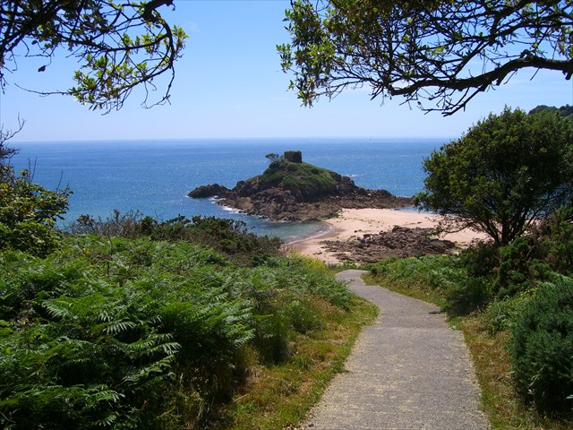
This cache is only available at or around low tide as it is on a tidal island.
Please plan your time around the low tide,
this link will take you to the local tide times.
Please do not take any risks, if in doubt, do not attempt.
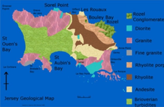
Jersey Geology
The geology of Jersey is characterised by the Late Proterozoic Brioverian volcanics, the Cadomian Orogeny, and only small signs of later deposits from the Cambrian and Quaternary periods. The kind of rocks go from conglomerate to shale, volcanic, intrusive and plutonic igneous rocks of many compositions, and metamorphic rocks as well, thus including most major types.
SILLS and DIKES
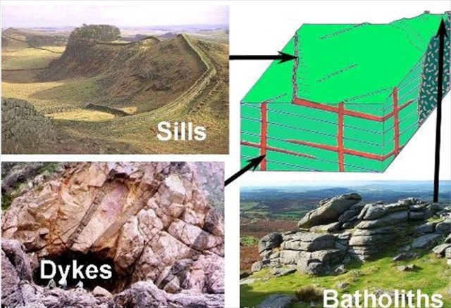
DIKES
A dike or dyke in geology is a sheet of rock that formed in a crack in a pre-existing rock body. However, when the crack is between the layers in a layered rock, it is called a sill, not a dike. It is a type of tabular or sheet intrusion, that either cuts across layers in a planar wall rock structures, or into a layer or unlayered mass of rock.
Dikes can therefore be either intrusive or sedimentary in origin. For example, when molten rock intrudes into a crack then crystallizes, it is an igneous dike. When sediment fills a pre-existing crack, it is a sedimentary dike.
Dykes are discordant or cross-cutting, wall-like, minor intrusive structures which vary in thickness. They are generally vertical or nearly so having been intruded from below along joint or fault planes to form dilation structures. They may occur singly, in sets or in swarms. The ones under discussion are composed of various types of igneous rock; no sedimentary ones have been recorded on Jersey.
SILLS
Sills are tabular versions of the above and have usually been intruded along bedding planes in sedimentary rocks and may transgress to other planes via joints. Jersey has none of these although some structures in the igneous rocks have been called sills.
Veins are very narrow, generally wall-like structures, vertical or inclined, in which minerals have crystallised, usually by growing out from the walls of the fracture in which they formed.
Jersey is an ideal place to study these structures. They occur throughout the island and can be seen wonderfully exposed along most of the easily accessible coastal sections.
St. Brelade's Bay and in the beach rocks immediately east and to the south and north of the harbour jetty; of note is the difference in strikes. They consist of:;
Dark grey dolerites standing out in stark contrast against the pink granites at Le Hocq on the south east coast.
Dark brown lamprophyres, often sparkling against the pink granites in Petit Portelet just north of Gorey Castle, in the cliffs at La Grève au Lanchon (Plémont) and near Belcroute on the east, north and south coasts respectively.
Light to medium grey rhyolite on the east side of Noirmont Pt. and porphyritic microgranites in the granite, maroon rhyolite and ignimbrites below Gorey Castle and along the coast to Anne Port respectively.
Multicoloured composite dykes and quartz-feldspar porphyries in the black and white diorites and gabbros of the south coast near La Motte (Green Island) and at Le Pulec cove on the north west coast.
Pink to red, finely crystalline aplite veins and dykes striking in several directions through the different coloured granites at La Corbière Point in the southwest, La Grève au Lanchon on the north west coast and at Le Dicq, just east of Le Havre des Pas on the south coast.
White quartz veins and white and yellow feldspar veins in the pink granites and the black diorites and gabbros, again on the south east coast; calcite veins occur in the Jersey Shale Formation and rarer minerals listed by Mourant (1961) such as barytes and fluorite.
Various mineral veins such as haematite and sphalerite in the granites and rhyolites, with rarer pyrite, chalcopyrite, molybdenum, lead and silver.
The dykes vary in strike from NE-SW to E-W along the east and south coasts with exceptions where rare dolerites strike N-S on parts of the north coast, while the mica lamprophyres exhibit variations from NE-SW, N-S to NW-SE, the last in the cliffs of La Grève au Lanchon.
Intersecting dykes occur, therefore giving their relative ages and some have curved strikes while others have been clearly sinistrally or dextrally tear-faulted. The majority clearly crop out parallel to major joint directions and the greater number have been described as forming the Jersey Main Dyke Swarm.
An absolute date is uncertain but may be c. 500Ma, ... "possibly coeval with the younger components of the SE Jersey plutonic complex"
The Cache
At the listed coordinates is a dike, to log this earth cache, please send me an email with the answers to the following questions:
(Please feel free to log as a find and send answers when able to)
1. Estimating or using a tape measure, what is the width of the dike at the listed coordinates?
2. On the east shoreline you will see the dike appears again, estimate or using your gps, measure the distance of it from the listed coordinates.
3. Describe the crystal size and colour of the dike and name the rock that is either side of the dike.
4. (Optional) Post a photo of yourself and/or gps with either of the dikes visible.
Additional Hints
(No hints available.)