
Il monte Titano (739 m s.l.m.) si presenta come un aspro sperone calcareo, situato più vicino il mare rispetto alla catena degli Appennino, che emerge per 200 metri d'altezza sopra un basamento d'argilla situato a 500 metri sopra il livello del mare. In linea d'aria dista soli 13 chilometri dal mar Adriatico. Costituisce l’estremità settentrionale di una ruga appenninica che si stacca dalla catena del Falterona. Sul versante orientale il monte strapiomba per quasi 200 m, mentre sul declivio occidentale è situata la cittadina di San Marino.
Geologia
Nell'era terziaria dove ora sorge la Repubblica San Marino c'era il mare. Violenti terremoti provocavano grossi sconvolgimenti della superficie terrestre e, a causa di uno di questi fenomeni, una massa rocciosa distante circa 80 chilometri dall'attuale monte, venne sollevata e lentamente scivolò verso il mar Adriatico. Questa massa rocciosa diede origine a vari monti tra cui il Fumaiolo e il monte Titano. Secondo gli esperti il Titano è soggetto ad un irregolare sollevamento bradisismico che fa strapiombare gli edifici nella zona della Città di San Marino.
Dal Cretacico al Pliocene si sono susseguiti alternati fenomeni tettonici, movimenti complessi della crosta terrestre, che hanno determinano lo spostamento per di terreni che si sono formati in zone assai diverse dalle attuali. I terreni della Coltre della Val Marecchia per questo motivo sono detti alloctoni. Sono invece detti autoctoni i terreni che trovano in posizioni immutate o solo leggermente spostate rispetto a quelle originarie di sedimentazione.
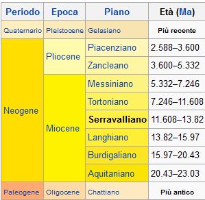
Formazione di San Marino - Affiora nei massicci del Monte Titano e di Monte Cerreto, ed anche in altre località. Alla base si rinvengono calcari organogeni grigio biancastri in strati spessi più di un metro e verso l’alto si passa a biocalcareniti grigio giallastre, in strati via via più sottili e con meno costituenti organici. Lateralmente si osservano marne e areniti poco cementate, grigie, nocciola e giallo verdastro. Alcune di queste fratture attraversano il Monte Titano per centinaia di metri. L’età della Formazione di San Marino è Langhiano Serravaliana. Questa unità cronostratigrafica si estende tra 13,82 e 11,608 milioni di anni fa. E l’ambiente deposizionale è passato da un mare poco profondo ad un bacino via via più profondo. Si rinvengono numerosi fossili, mentre sono più rari i minerali.
Qui a San Marino si trovano in alcuni punti con affioramenti di queste rocce. Principalmente troviamo arenaria.
L'arenaria è una roccia sedimentaria composta di granuli dalle dimensioni medie di una sabbia. Tra i grani più resistenti all'abrasione e all'alterazione chimica comunemente abbondano quelli di quarzo, minerale che, proprio per la sua resistenza, è uno dei costituenti più comuni di queste rocce. I granuli sono tra loro legati da un cemento, originato dalla precipitazione chimica di minerali formati da ioni presenti nelle acque circolanti fra i pori interstiziali, comunemente come cemento si rinviene il carbonato di calcio sia sotto forma di calcite che di aragonite.
Per loggare questa cache inviatemi le risposte ai seguenti quesiti e postate una foto di voi (o del vostro GPS)
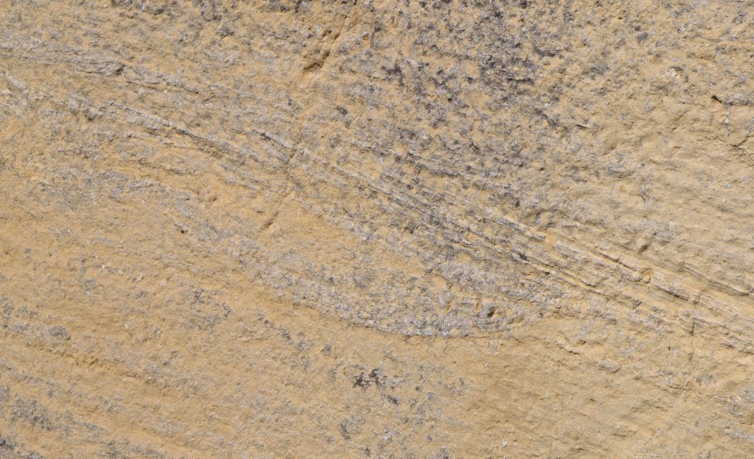
1.)WP1: Sul Lato sinistro del parcheggio si trova la tipica stratificazione della pietra arenaria. Come spessore sono i singoli strati ( vedi Spoiler foto)?
2.)WP2: Il blocco di calcare esposta è rivestita con calcite. Descrive brevemente la forma, il colore e la forza.
3.)WP3: Qui potete vedere il passaggio dal calcare a arenaria ( sul lato sinistro nella regione della stemma). Descrive brevemente le differenze e la transizione dal calcare a arenaria.
4.)WP4: A quale l’angolo sono gli strati sotto il 2. torre?
In seguito potete immediatamente loggare. Se qualche cosa non è corretto, vi contattiamo.

Monte Titano (739 m ü.NN.) präsentiert sich wie ein zerklüfteter Kalkstein-Vorsprung. Er liegt näher am Meer als die Kette des Apennin, die 200 Meter über der Basis aus Lehm und 500 Meter über dem Meeresspiegel liegt. Er liegt Luftlinie nur 13 km von der Adria entfernt. Er bildet das nördliche Ende einer Falte, die den Apennin Falterona verlässt. Die östliche Seite des Berges ragt fast 200 m senkrecht empor, während am Westhang die Stadt San Marino liegt.
Geologie
Im Tertiär, wo jetzt die Republik San Marino ist, war dort das Meer. Heftige Erdbeben verursachten große Umwälzungen der Oberfläche der Erde, und als Ergebnis eines dieser Phänomene, ist diese Felsmasse, die etwa 80 km vom aktuellen Berg aufgerichtet wurde und langsam in Richtung Adria abflacht. Diese Felsmasse führte zu verschiedenen Bergen unter ihnen der Monte Titano und der Fumaiolo. Experten zufolge unterliegt der Monte Titano einer ungezähmten Anhebung, in deren Zone jetzt die Stadt San Marino steht.
In der Kreidezeit zum Pliozän gab es tektonische Phänomene, die sich abwechselten. Komplexe Bewegungen der Erdkruste , die aufgetreten sind, bewirkten die Verschiebung des Terrains in sehr unterschiedlichen Bereichen, wie sie gegenwärtig zu sehen sind. Aus diesem Grund werden die Böden das Grabtuchs Val Marecchia genannt. Sie werden als autochthone Böden bezeichnet, die in den Positionen unverändert oder in Bezug auf die originale Sedimentation nur leicht verschoben sind.
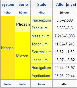
Die Formationen von San Marino treten am Massiv des Monte Titano und auch in anderen Orten zu Tage. An der Basis werden organische Kalksteine weißlich-grau in dicken Schichten mit über einen Meter gefunden. Nach oben passiert man grau-gelbliche Schichten, die allmählich dünner werden und weniger organische Bestandteile besitzen. Seitlich beobachtet man Mergel und Sandstein, der wenig zementiert ist mit einer Farbe von grau-braun bis grünlich-gelb. Einige dieser Schichten überziehen den Monte Titano über hunderte von Metern. Das Alter der Formation San Marino ist Langhium Serravalium. Das ist die chronostratigraphische Einheit vor zwischen 13.82 und 11.608 Millionen Jahren. Der Ablagerungsraum hat sich von einem flachen Meeresbecken zu einem allmählich tiefer werdenden Meer verändert. Es konnten viele Fossilien gefunden werden, allerdings seltener Mineralien.
Hier in San Marino befinden sich an einigen Stellen Aufschlüsse dieser Gesteinen. Überwiegend findet man Buntsandstein.
Der Sandstein ist ein Sedimentgestein aus Granulat von der durchschnittlichen Größe von Sand. Zwischen ihnen sind Körner, die widerstandsfähig sind gegen Abrieb und chemische Einflüsse, üblicherweise aus Quarz, einem Mineral, das aufgrund seiner Beständigkeit, einer der häufigsten Bestandteile dieser Felsen ist. Die Granulate sind durch einen Zement verbunden, der aus der chemischen Ausfällung von Mineralien stammt, wenn Wasser in den Zwischenräumen der Poren zirkuliert und Ionen gebildet werden. Üblicherweise wird der Zement als Calciumcarbonat in Form von Calcit und Aragonit gefunden.
Bitte macht optional ein Foto von euch ODER eurem GPS (mit sichtbaren Koordinaten) und fügt es eurem Log-Eintrag hinzu.
Außerdem schickt mir eine Mail mit folgenden Angaben:
1.)WP1: An der linken Seite des Parkplatzes findet ihr die typische Lagenweise Schichtung des Sandstein. Wie dick sind die einzelnen Lagen ( siehe Spoiler-Foto)?
2.)WP2: Der ausgestellte Kalksteinblock ist mit Calcit überzogen. Beschreibe kurz Form, Farbe und Festigkeit.
3.)WP3: Hier erkennt man den Übergang von Kalkstein zu Sandstein (an der linke Seite im Bereich der Wappen ). Beschreibe kurz die Unterschiede und den Übergang von Kalkstein zu Sandstein.
4.)WP4: In welchem Winkel fallen hier die Schichten unterhalb des 2.Turmes ein?
Danach könnt Ihr sofort loggen. Wenn irgendetwas nicht in Ordnung sein sollte, melden wir uns.

Monte Titano (739 m asl) is akin to a craggy limestone outcrop. He is closer to the sea than the chain of the Apennines, which is 200 meters above the base of clay and 500 meters above sea level. He lies straight line, just 13 km from the Adriatic Sea. It forms the northern end of a fold that leaves the Apennines Falterona. The eastern side of the mountain rises nearly 200 meters straight up, while on the western slope lies the city of San Marino.
Geology
In the Tertiary, where now is the Republic of San Marino, there was the sea. Violent earthquake caused great upheaval in the earth's surface, and as a result of these phenomena, this mass of rock, which was erected some 80 km from the current mountain and slowly taper off towards the Adriatic Sea. This rock mass led to various mountains including the Mount Titano and the Fumaiolo. According to experts, the Monte Titano is subject to an untamed increase in their zone, where now the city of San Marino stands.
In the Cretaceous to Pliocene there was tectonic phenomena which alternated. Complex movements of the Earth's crust that have occurred, caused the displacement of the terrain in very different fields, as they are currently seeing. For this reason, the floors, are called the grave cloth Val Marecchia. They are called autochthonous soils, that are unchanged in the positions or only slightly shifted with respect to the original sedimentation.
The formations of San Marino occur at the massif of Monte Titano and in other places to days. At the base of organic limestones are whitish-gray found in thick layers with more than one meter. To the top there are gray-yellowish layers, which are gradually thinner and have less organic ingredients. Laterally you can observe marl and sandstone, that is cemented with a little color from gray-brown to greenish-yellow. Some of these layers coat the Monte Titano for hundreds of meters. The age of the formation of San Marino is Langhium Serravalium. This is the stratigraphic unit from between 13.82 and 11,608 million years ago. The depositional environment has changed from a shallow marine basin to a gradually deepening sea. It could be found many fossils, but rare minerals.
Here in San Marino are located outcrops of these rocks in some places. You find predominantly sandstone.
The sandstone is a sedimentary rock composed of granules of the average size of sand. Between them, are grains, that are resistant to abrasion and chemical influences, usually made of quartz. That mineral, because of its resistance, is one of the most common ingredients of this rock. The pellets are joined by a cement, which originates from the chemical precipitation of minerals, if water is circulating in the interstices of the pores, and ions are formed. Typically, the cement is found as calcium carbonate in the form of calcite and aragonite.
Make a picture of you or your GPS standing at this point. Please upload this picture optional with your log. To successfully log this cache, please answer the following questions and mail the answers to us:
1.)WP1: On the left side of the parking place you will find the typical stratification of sandstone. How thick are the individual layers ( see spoiler photo)?
2.)WP2: The exposed limestone block is coated with calcite. Briefly describe the shape, color and strength.
3.)WP3: Here you can see the transition from limestone to sandstone ( on the left side in the region of the coat of arms). Briefly describe the differences and the transition from limestone to sandstone.
4.)WP4: At what angle here fall below the layers of the 2. tower?
After that you can give your log directly. If anything is not ok, we will contact you.
l'indice delle fonti:
· educazione.sm/agenzie/CentroNaturalistico
· Wikipedia
· Fotos intrinsecamente