Deutsch:
(Thank you Ben0w for graciously helping with this translation!)
Eine Gletschermühle (französisch: "moulin") ist ein schmaler senkrechter Schacht in einem Gletscher, in dem Wasser von der Oberfläche zur Basis abfließen kann. Sie wird durch Schmelzwasser geschaffen, das sich in einer Gletscherspalte oder einer anderen Schwachstelle sammelt und beginnt, sich durch Erwärmung und turbulente Strömungen in das Eis zu bohren. Diese vertikalen "Flüsse" dienen als internes Rohrsystem des Gletschers, das Schmelzwasserseen von der Oberfläche ableitet. Sie können hunderte Meter tief sein und (bisher) bis zu 10 Meter Durchmesser erreichen. Das Wasser fließt bis zum Grund des Gletschers oder bis es auf einen anderen Kanal des Systems trifft.
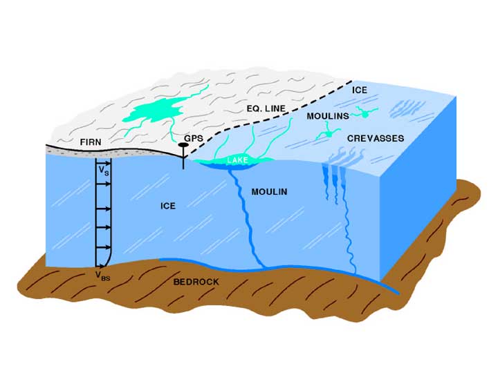
Image Source : Pressemitteilung der NASA ursprünglich aus dem Jahr 2002 , bei Wikipedia gespeichert
Wenn ausreichend Wasser zufließt, kann sich eine Gletschermühle leicht innerhalb von wenigen Wochen bilden. Mühlen ohne dauerhaften Schmelzwasserzufluss können sich bei Bewegung des Eises schließen oder im Winter mit Schnee füllen. Manche Mühlen bleiben für Jahre an der gleichen Stelle erhalten, obwohl diese Stelle mit der laufenden Bewegung des Eises wandert. Die Rolle von Gletschermühlen bei der Wanderung von Gletschern ist komplex und immer noch Gegenstand von Untersuchungen. Schmelzwasser an der Gletscherbasis kann als Gleitflüssigkeit dienen, die dem Gletscher die schnellere Fortbewegung erlaubt, es beschleunigt aber auch den Zerfall des Gletschers. Wenn sich ausreichend Wasser unter dem Eis ansammelt, kann es das Eis aus dem Gletscherbett heben. Dies verändert den Widerstand, der auf das Eis wirkt. Die Druckänderung erzeugt neue Belastungen auf den Gletscherkörper, die seine Struktur schwächen können. Forscher untersuchen weiterhin diese komplexe Interaktion zwischen Klimawandel, Gletscherbewegungen und dem Anstieg des Meeresspiegels.
Das fallende Schmelzwasser in einer Gletschermühle kann Sand und Kies mit hoher Geschwindigkeit mitführen und Wirbel bilden, die als Drehmeißel wirken und innerhalb weniger Jahre große Löcher erodieren. Wenn es in Kontakt mit dem Felsbett unter dem Geltescher kommt, kann es kreisrunde Löcher in die Oberfläche bohren. Die Höhlung, die durch Steine, Geröll und andere Trümmer mit dem wirbelnden Wasserstrom im umgebenden Felsboden entsteht, wird Gletschertopf genannt.

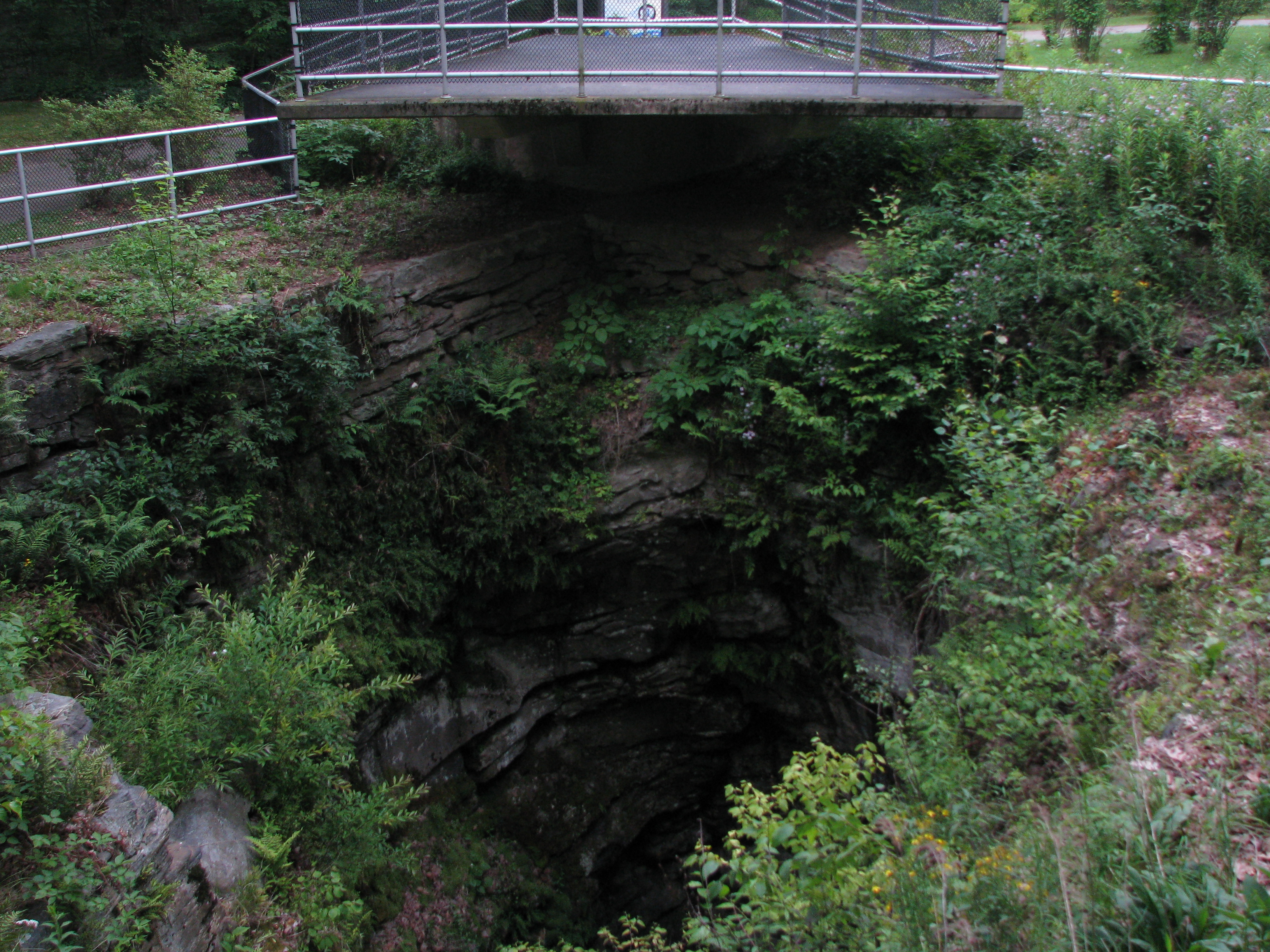
Fotos : Gletschergardens , Luzern (von http://www.gletschergarten.ch) und Archbald Pothole State Park, Pennsylvania ( from Wikipedia)
Gletschertöpfe können auf der ganzen Welt als Hinterlassenschaften von Gletschern gefunden werden. Der Gletschergarten in Luzern zeigt beeindruckende Höhlungen verschiedener Größen, darunter ein im Jahr 1870 entdecktes Loch mit 7,5m Durchmesser und 9,8m Tiefe. Der größte derzeit bekannte Gletschertopf ist das Archbald Pothole in Pennsylvania, das 11,6m Tiefe und im Durchmesser 12,8m mißt. Kleinere Gletschertöpfe können auch auf Bergkuppen und über den Boden eines Gletschertales verteilt gefunden werden, zum Beispiel im Lauterbrunnental, das durch Gletschererosion geformt wurde.
An den gelisteten Koordinaten findest Du einen großen Fels, der einen Gletschertopf enthält.
Um den Cache zu loggen, schicke mir bitte Deine Antworten auf folgende Fragen:
1. Schätze die Breite und die Tiefe des Gletschertopfes ab.
2. Befühle die Wände des Gletschertopfes. Sind sie glatt oder rau? Was denkst Du, wie das geschehen ist?
3. Laut der Information, die in der Nähe angebracht ist: wie hoch kann die Geschwindigkeit des Schmelzwassers sein?
English:
A glacier mill, also known as a moulin (French for "mill"), is a narrow vertical shaft in a glacier that provides a pathway for water to travel from the glacier's surface to its base. It is formed when melted water travels from the surface into a crevasse or other weak spot in the ice and through its heat and turbulence, begins to drill down into the ice. These vertical "rivers" serve as a glacier's internal plumbing system, carrying water out of the glacier from melt water lakes on the surface. They can be hundreds of meters deep and (so far) up to 10 meters (33 feet) wide. The water continues down until it reaches the bottom of the glacier or until it reaches another conduit in the glacier's drainage system.
Image Source: NASA press release originally from 2002, stored at Wikipedia
With enough water flow, a moulin can form easily over the course of just a few weeks. Moulins without a meltwater supply may close as the ice moves or may fill with snow over the winter. Some moulins have remained in the same spot for many years, though the spot constantly moves forward with the flow of the ice. The role of moulins in glacial motion is complex and still under investigation. Meltwater at the base of the glacier may act as a lubricating fluid, allowing glaciers to flow faster but also possibly speeding disintegration of the ice sheet. If enough water drains below the ice, the water can lift the ice off the bed. This changes the amount of resistance acting on the ice. The change in pressure creates new stresses on the body of the glacier which may weaken its structure. Researchers continue to study this complex interaction of climate change, glacial motion, and sea level rise.
The falling meltwater in a moulin can carry sand and gravel at high speed, forming a vortex that acts like a powerful lathe that can erode large holes within a few years. When it comes into contact with the bedrock beneath the glacier, it can bore a cylindrical hole into the surface. The cavity drilled into the surrounding bedrock by stones, gravel and other detritus within an eddying water current is called a giant's kettle, or giant's cauldron. The giant's kettle formed by a moulin is referred to as a glacial pothole or a moulin pothole.
Photos: Gletschergardens, Lucerne (from http://www.gletschergarten.ch) and Archbald Pothole State Park, Pennsylvania (from Wikipedia.)
Glacial potholes can be found all over the world in the aftermath of glaciers. The Glacier Gardens in Lucerne showcase dramatic potholes of different sizes, including one discovered in the 1870s measuring 25 feet (7.6 m) wide and 32 feet (9.8 m) deep. The largest currently known glacial pothole is the Archbald Pothole in Pennsylvania, measuring 38 feet (11.6 m) deep and 42 feet (12.8 m) in diameter. Smaller potholes can also be found on hilltops and scattered over the floor of a glacial valley such as the Lauterbrunnen Valley, which was formed by glacial erosion.
At the posted coordinates, you will find a large rock with a glacial pothole in it.
To log this cache, please email me your answers to the following questions:
1. Estimate the width and depth of the pothole.
2. Feel the walls of the pothole. Are they smooth or rough? How do you think this happened?
3. According to the information posted nearby, how fast can the meltwater speed be?
References:
1. "Moulin." Encylopedia Brittanica online.
2. "Experts explain science behind glacier holes." Fairbanks Daily Newsminer: April 17, 2013.
3. "Moulin 'Blanc': NASA Expedition Probes Deep Within a Greenland Glacier." Nasa Press Release: December 11, 2006 .
4. http://www.global-greenhouse-warming.com/moulin.html