 |
The cache is called the Explorer 172 Challenge because each of the 172 different caches you need to have found to qualify must be in a different British Ordnance Survey grid square as depicted on the Explorer 172 Chiltern Hills East map. |
| The caches can be of any type, previous finds qualify (including those finds now archived and events attended (even if you were the host)), in fact just about any cache other than those you have placed yourself can be counted. |
| To find out more about this and other Explorer Challenge caches, go to www.pppgeo.co.uk/explorer.html which has been created to complement the cache series. |
 |
 |
 |
|
 |
 |
 |
The grids on the map "start" to the north west of High Wycombe at SU 80000 99000 |
 |
 |
 |
|
| |
| |
 |
 |
 |
| and finish to the south east of Uxbridge at TQ 09000 80000 |
 |
 |
 |
| |
 |
 |
 |
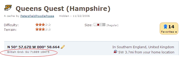
| From personal experience I know how time consuming trying to determine which of 600 squares of an OS map a cache qualifies for, although of course the British Grid reference is given at the top of each cache page just below the main co-ordinates shown in bold, as circled below. |
 |
For the purposes of this challenge the published co-ordinates of all caches, including Unknown/Mystery and Multi caches are those that are to be used when determining which square a cache counts towards
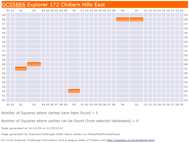
To help those of you that want to plan your finds a GSAK Macro has been written which produces a web page of your finds, example output shown below.
When you have found the 172 caches you need to provide proof of that fact to be eligible to claim a find on the cache; this can be via one of any number of different methods you may have available:
- List the 172 cache codes and names in corresponding grid reference order in your found log
- Create a public bookmark list
- Send the GSAK Macro generated file to us via our profile or add it to your profile page
- Send us your "My Finds" Pocket Query and we will run the GSAK Macro for you and let you know if you qualify and if not which squares you still need to find a cache in to qualify
- There is now a handy checker on Project-GC, see below!

Any finds without proof of qualification will of course be deleted! Have fun!
The parking area at the suggested parking coordinates is limited ( 3 cars at most) . There is a picnic site and parking at the foot of the hill on the map but this is currently unavailable and shows no signs of reopening.
It is near to a 2002 cache which should be visited whilst you are here http://www.geocaching.com/geocache/GC70BE_wooburn-view# , there are great views across Wooburn Green from this cache
BEWARE the path to this cache, which forms part of the Chiltern Way Berkshire Loop, will be muddy after rain ( as I experienced this week!) .
Please REPLACE the cache exactly as found to ensure it cannot be spotted.
Congratulations to Lindylew and pfoagain for joint FTF
Many many thanks to PetersfieldPoodlePosse who created all the difficult stuff on this page leaving me to add these few specific items of information.