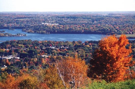
Rib Mountain State Park was established in 1934, and covers 1500 acres of the most amazing terrain in Wisconsin. At almost four miles long, Rib Mountain is also home to Granite Peak Ski Area as well as several TV and radio antennas.
While some believe that the mountain was formed by an extinct volcano, it is not made up of volcanic material. Rib Mountain is actually composed of a single large block of quartzite, and is one of the oldest geological formations on earth. The super hard quartzite was formed one and a half to two billion years ago by the fusion of sandstone. Some of the quartzite still contain the ripples formed by an ancient sea, and are the topic of an Earth Cache within the park.
The 17 miles of trails have a total elevation change of over 700 feet. If you choose to walk to the top of the observation tower, you will be rewarded with a breath taking view of Marathon County.
The cache can be found by following the red trail. Please watch your step.
A current Wisconsin State Park sticker is required to park a vehicle in any part of the park at any time of year.
This region is right in the middle of our state, easy to get to from everywhere else. Its biome is sand plains and prairie. The landscape was largely shaped when it sat at the bottom of huge Glacial Lake Wisconsin, which left behind sandy soils and a fairly flat landscape. One still can find eroded sandstone buttes, believed to have been islands during this time period, and certainly striking features as one travels through the region. There are scattered mixed hardwoods and pine plantations, as well as large areas of wetlands and grasslands. Prairie Chickens do their spring dances in this region. The threatened Karner Blue Butterflies live here, as do river otters. Timber Wolves have reached their southern range in this biome.
WISCONSIN GEOCACHING ASSOCIATION
The Wisconsin Geocaching Association (WGA) is a group of geocachers dedicated to promoting and protecting geocaching within the state of Wisconsin. The WGA organizes geocaching events, works with land owners/managers on geocaching policies, educates the public at large about geocaching, and facilitates communication between WGA members. To learn more about the WGA visit: wi-geocaching.com.
2013 kicks off the beginning of the Wisconsin Geocaching Association State Parks series. It is our goal to place a geocache in every state park in the state of Wisconsin, so watch out for more in this series that encourages geocachers to explore the natural resources in this beautiful state of ours.
The Geocache Notification Form has been submitted to William H. Bursaw of the Wisconsin DNR. Geocaches placed on Wisconsin Department of Natural Resource managed lands require permission by means of a notification form. Please print out a paper copy of the notification form, fill in all required information, then submit it to the land manager. The DNR Notification form and land manager information can be obtained at: http://dnr.wi.gov/files/PDF/forms/2500/2500-118.pdf