Aldborough lies three miles west of the A140 between Aylsham and Cromer. The village and its church and mill are listed in the Domesday Book.
Aldborough has always had some importance as a trading centre. King John granted a charter for a fair to be held on or near 21st or 22nd June each year. This was originally for the sale of horses, livestock, poultry and household goods as well as a hiring fair for servants and labourers. In the late 19th century it gradually became more of a pleasure fair and today the dodgems, shooting booths , roundabouts and all the fun of the fairground come to the green on the traditional dates.
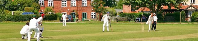
The green is the main feature of the village and a natural centre. The shops and most of the older houses are grouped round it. The pub is at one corner, the community centre at another. A playground can be found at one end but the middle part of the green is a football pitch in the winter and a cricket ground in the summer.
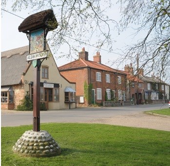
As with many Village Signs this is situated on the Village Green. One side of the sign depicts a a scenr from th medieval fair, The other side shows a traditional game of cricket which can often be seen and enjoyed on the large village green.
Aldborough was self sufficient in its trade and industries until the mid 20th century. There was also some illicit trading: Watch Oak on Hall Road is reputed to have been a look out point for a signal from Cromer that the brandy was ashore!. Glove making is mentioned in 14th century records and continued until the 19th century. There were two tanneries, two harness makers and saddlers, a whip maker, a basket maker, two bakeries, two butchers, a tailor and a dressmaker, two carpenters, workshops, a smithy and a watch maker as well as four general stores, a post office, a boot and shoe shop, a stationers two pubs and a garage. All of these were still in existence and are mentioned in a village history and survey dating from 1937. The number of shops have dwindled over the years but some still survive.
Although the village and church have existed for so long, there is no evidence of domestic buildings from the medieval period. The Black Death affected this area and its population in the 14th century and it is assumed that houses near the church were abandoned, or destroyed, and new houses built round the green. Part of a field is named poison green in old maps and is reputed to be a plague pit. The oldest houses round the green are known to be late 17th and early 18th century. The main part of the old rectory was reconstructed in the reign of William IV, but the north wing is much earlier.
Aldborough Hall is about a mile from the village in the direction of Holt. The oldest section is 16th century with additions and alterations in 1636, 1750 and 1816.. It was occupied by the Gay Family from 1613 until the last member to bear the name married the Rev Christopher Lilly; she is commemorated in the naming of Margaret Lilly Way.
The walk follows footpaths and quiet roads. There is no particular starting and finishing cache, and they can all be done as stand alone caches.
After a long period of absence, the Village Sign has returned. The images have changed and so you will need to find the following information in order to work out the final location of the cache.
You need to go to the listed coordinates and answer the following questions:
For the Northings please find the following information on the ‘Medieval Fair’ side of the sign
A = How many people in the group surrounding the table + number of sheep?
B = How many people are not wearing a hat or head covering?
C = How many items (including the cup) are on the table?
For the Eastings please find the following information on the ‘sporting’ side of the sign
D = How many crickets on the pitch?
E = How many buildings have windows in the roof?
F = How many panes of glass in the yellow door?
The final cache location can be found at: N52 51.ABC E001 14.DEF
Checksum = 49
**************************************
If anybody would like to expand this series please do. I would just ask that you let SmokeyPugs know first so they can keep track of the Village Sign numbers and names to avoid duplication..
*************************************