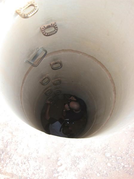
חוות עברונה היא חווה חקלאית מהתקופה המוסלמית הקדומה (מאה 8-7 לסה"נ). החווה כוללת שלושה מבנים, מערכת מים ושטח חקלאי תחום בקיר. תושבי החווה התפרנסו מחקלאות שלחין (תמרים, קטניות, ירקות), ממרעה, הפקת נחושת ומתן שירותי דרך. החווה ניצלה את מי השיטפונות שהגיעו לערבה וחלחלו אל מי התהום. מערכת המים של המקום מבוססת על שיטה הנקראת בארות שרשרת. מדובר בשרשרת של פירים המחוברים אל אותה המנהרה. הפיר העליון ביותר מגיע אל מפלס מי התהום ומזרים אותם אל המנהרה. שאר הפירים אינם בארות, וכל תפקידם היה לסייע על מלאכת החפירה, ולכן המרחק בין פיר לפיר אינו גדול. שני הפירים הדרומיים והרדודים ביותר במנהרה המזרחית נחפרו בחפירה ארכיאולוגית, וניתן להיכנס אליהם וללכת לאורך המנהרה (בעזרת פנס). רוחב המנהרה כ 60 ס"מ וגובהה כ 130 ס"מ. היא נחצבה משני הצדדים וחוצביה טעו בכיוון האופקי בהפרש של 1 מ' אותו תיקנו לקראת המפגש. המטמון נמצא בתוך המנהרה, בערך באמצע הדרך בין שני הפירים, בגובה 2 מ', בנקודה הכי גבוהה במנהרה. כדי למצוא אותו תצטרכו לרדת בסולם לעומק של כ-4 מטרים ותזדקקו לפנס.
אחרי הביקור בבארות ניתן ללכת דרומה כ 400 מ' ואח"כ לצעוד לצידה של תעלת מים מקורה, עד שמגיעים אל בריכת האגירה בה נאגרו מי הבארות. ליד הבריכה נמצא אחד משלושת מבני החווה בו נמצאו מטבעות וחרסים מהתקופה.
גישה: מכביש 90 נפנה מזרחה (לבאים מאילת - ימינה) בק"מ מספר 20, ניסע 100 מ', נפנה שמאלה, צפונה, בכביש הישן לאילת (סימון ירוק) וניסע כ-1.3 ק"מ. נעצור את הרכב בחניה הצמודה לסככת המבואה, נלך כ-400 מ' צפונה ונגיע אל שני פירים סמוכים ופתוחים המוגנים בגדר, אשר נחשפו בחפירה ארכיאולוגית והם חלק ממפעל המים של חוות עברונה העתיקה.
במידה ורוצים לחזור לאילת מומלץ להמשיך דרומה על גבי הכביש הישן לאילת. אם תחזרו אל כביש הערבה, אין פנייה דרומה ועליכם יהיה לנסוע צפונה כ- 5 ק"מ ולעשות פרסה.
מקור: צביקה צוק
Evrona farm is an agricultural farm from the early Muslim period (7-8 centuries). The farm includes three buildings, an irrigation system, and a walled agricultural area. The farm inhabitants lived from agriculture, pasture, and copper production.
Irrigation was based on the qanat system that used water from the aquifer from a well, a tunnel, and a series of shafts.
The cache is located in a tunnel approximately in the middle between the two shafts that were excavated. In order to reach the cache you will need to climb 4 meters down a ladder and crouch down in the tunnel until you reach the highest point in the tunnel – 2 meters high. You will also need a flashlight.
After visiting the qanat you can walk 400 meters to the south, and then aside the water canal, until you reach the water reservoir and one of the archeological ruins where coins and shards were found.
Access: From Eilat drive on road 90, take a right (east) after the 20km milestone. Drive 100 meters, turn left (north) to an old asphalt road and drive 1.3 km. Park near the shed. Walk 400 meters north and you will see the two shafts.
When leaving back for Eilat you will need to drive 5 km north on road 90, and then take a U-turn.
Source: Zvika Zuk