Nice Gneiss!
Safety warning:
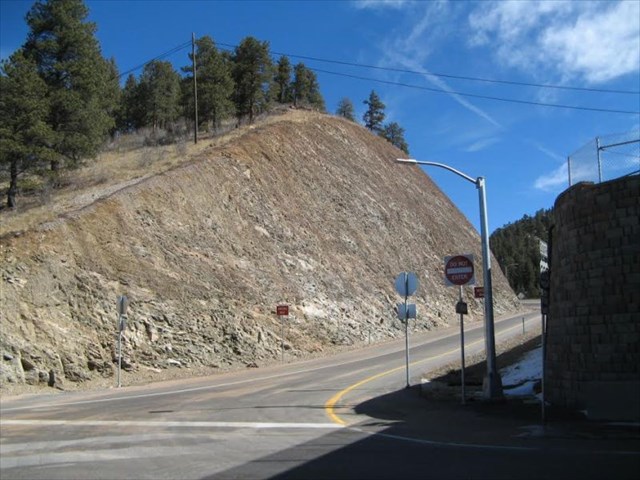
Please be careful when you visit this site, especially with children or pets. This is a road cut next to a traffic lane. Vehicles are leaving a 55 mph speed zone on a state highway onto a down-sloping off ramp with a stop sign at the bottom. In winter, roads may be slick.
Park only in a safe, legal spot, for just long enough to visit this earthcache. Use your hazard lights if your car is parked at the shoulder. Walk carefully to the site. Children and pets should remain in your vehicle. Stay off the asphalt surface while visiting this rock cut.
Be on the lookout for falling rocks and moving vehicles. There is no need to climb on the rocks. The net at the top of the roadcut indicates that it is an active area of rockfall, and caution should be exercised accordingly. Do not take any rocks. Do not disturb any survey markers, signs, barriers, fences, etc., that may be at this site.
In other words, please exercise due caution and use your good manners and common sense when visiting this earthcache.
"That's a gneiss rock."
"Well, we wouldn't want to take it for granite."
OK, that joke was old when these rocks were new.
But, just so you don't take these nice rocks for granted, let's look at how to recognize what they are, and what they tell us about the geologic history of the area.
The recent roadwork done at this site in conjunction with the opening of Staunton State Park has exposed a lovely fresh outcrop where we can examine some of the oldest rocks in this part of the state. This site is not within or even directly adjacent to the park. However, the rocks exposed here are very similar to some of the rocks that can be found within the park.
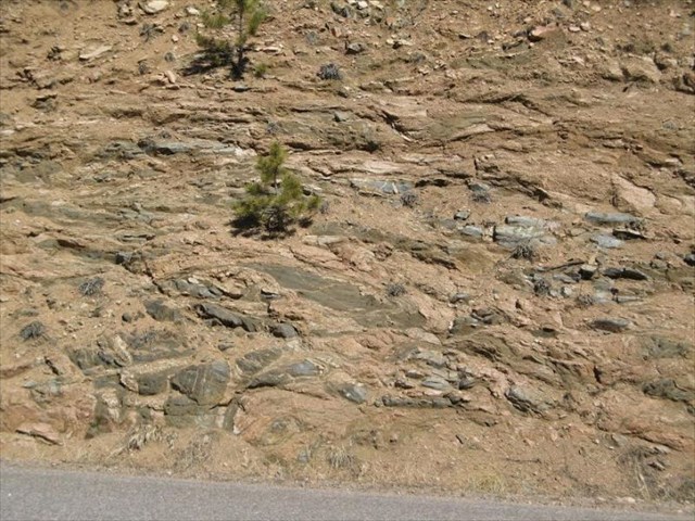
Look carefully at the rocks, both in the outcrop and on the ground. What do you see?
Chances are that you see layers of different colors, light and dark. Is this a sandstone? Some kind of sedimentary rock? No. In spite of the superficial resemblance from a distance, these are something quite different.
It's possible that this used to be a sandstone. Or maybe a mudstone. Or a lava flow. After the original rock formed, though, it was buried deep in the earth. Great pressures were applied both from the weight of the rock above as well as from subduction, collisions, faulting, and other tectonic stresses. In addition, the rock was subjected to much hotter temperatures due to the natural geothermal gradient and nearby magma chambers.
The minerals of the original rock were no longer stable in this new environment. They reacted with each other to form new minerals. The original minerals broke down and recrystallized into new minerals with new textures. This process is called metamorphism. The rocks that result from this are called metamorphic rocks.
The new minerals tell us something about how deeply the rocks were buried and how hot they were at the time. Different minerals form at different temperatures and pressures. The minerals tend to line up in layers or lines that reflect the stresses that were present when they formed. This gives the rock a distinctive fabric which can tell us something about the tectonic history of an area.
What does this have to do with the rock in front of you?
The textures and minerals of a metamorphic rock are very distinctive. The rock in front of you has those diagnostic characteristics -- a layered appearance, a somewhat chaotic swirl of differently-colored streaks and pods and layers, and intermixed crystals of minerals that are stable together at high temperatures and pressures. Yes, this is a metamorphic rock.
We can name the rock. We can figure out how deep it was when these minerals formed and thus how much uplift and erosion has occurred since then. We can say something about the geologic stresses during and after their formation, and we can make a pretty good determination of what was happening in Colorado back then.
Name that rock!
Given the name of the earthcache, you are probably surmising that this is a gneiss. That's a fair guess. How can you tell?
A gneiss is a metamorphic rock that has layers of lighter and darker minerals. The layers can be continuous or discontinuous. This layering is called gneissic banding or foliation. The rock's texture is coarse-grained, meaning that you can see individual crystals. The lighter bands are dominated by feldspar, quartz, and other light-colored minerals that are rich in sodium, potassium, and aluminum. The darker bands have minerals richer in iron and magnesium and in this outcrop are dominated by biotite, a type of mica. (Biotite is black and shiny, and often has the appearance of thin flakes and sheets.)
Here is a brief key to naming metamorphic rocks. At its most basic, metamorphic rocks are classified by their texture and composition. Pick up a rock that is on the ground in front of you or look at a rock that is still attached to the outcrop. Examine it and use the following chart to name what kind of rock it is. Hint: it is foliated (i.e. layered).
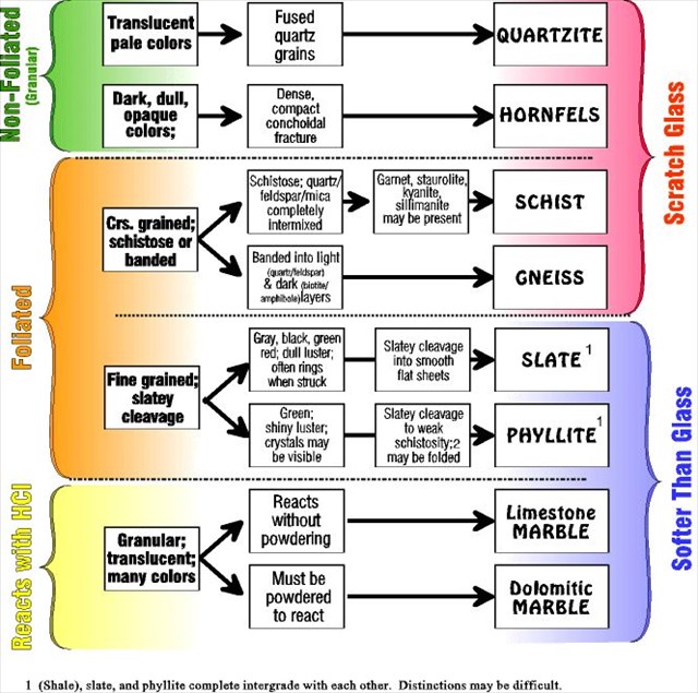
So, what do you think? Gneiss or not so gneiss? What features lead you to that conclusion?
Metamorphic grade
Metamorphic grade is a measure of how much metamorphic change has occurred. It is a shorthand way of saying how deep the rocks were and how hot they were when the metamorphism occurred. The more different the conditions were compared to surface conditions, the higher the grade.
Use this chart and determine if this is a low, intermediate, or high-grade metamorphic rock.
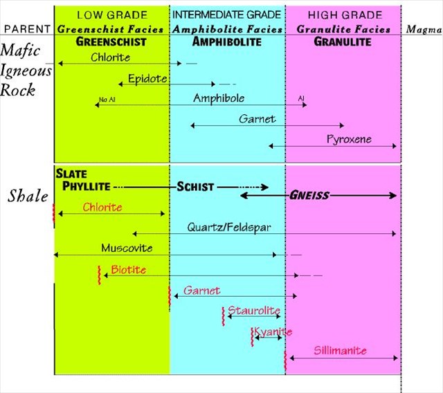
Petrographic analysis of rocks near here tell us that the minerals present are quartz, feldspar, biotite, hornblende (amphibole), sillimanite, and a few other odds and ends. Given that, and given the textures of the rock, we can estimate that the minerals in this rock formed in a tectonic environment of compression and mountain- building, at temperatures over 500C, and probably at 10-20km beneath the surface.
Wow, just think of how much erosion and uplift that represents!
Stresses and deformation
This type of metamorphism usually forms in a directed stress field. In other words, the rocks are being mashed together, faulted and folded, sheared past each other, and so on. That is why there is foliation. The minerals line up perpendicular to the direction of maximum compression.
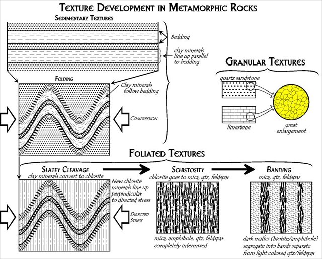
If the stresses continue after the minerals form, the foliation might bend and fold, pods of different minerals might form, there might be breaks and discontinuities in the rock layers, and so on. There can be repeated episodes of folding and faulting, each of which leaves its mark on the rocks.
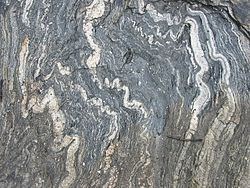
Is the foliation in this outcrop parallel everywhere? Is there some sign of later folding? Signs of different stresses would be folds and breaks in the foliation, little squiggly (as opposed to straight) veins of lighter material, pods and lenses of lighter and darker material. There are other signs that can be seen with a microscope or detected through various kinds of chemical analysis, but those are beyond the scope of this earthcache.
Putting it all together
You now know how to recognize a gneiss. You know what it says about the intensity of metamorphism here and also how much uplift has occurred since then. You can identify some of the evidence of deformation that occurred during and after the metamorphism. That's great! You can use your new knowledge anywhere in the world! You might even be able to use it in kitchens, bathrooms, and public buildings that include slabs of gneiss for countertops, floors, and other decorative accents.

That is all wonderful stuff, but what does it all mean?
Gneisses like this often occur in areas of intense tectonic conditions. They are common in areas that went through one or more episodes of mountain building, either through two continents colliding or from a continental subduction zone. Great thickness of rock pile up, there is great stress, and there is often heat from deeper rocks that melt and rise through the crust as magma. The rocks cook, they change, they fold and shear like taffy. Eventually, with much time, the overlying rock can erode and expose these much-abused gneisses.
Chemical analysis of the metamorphic rocks in this region show that they are probably associated with volcanic islands long ago. Imagine something like modern-day southeast Asia and northern Australia near the Banda Sea -- continents with complicated subduction zones and chains of volcanic islands offshore. The metamorphic rocks of this age here in Colorado have compositions and sometimes even preserved textures of sandstones, conglomerates, lavas, mudstones, and some limestones that are typical of a volcanic island arc setting.
How long ago? According to age-dating, 1.75-ish billion years ago. So, approximately 1.75 billion years ago, the edge of the North American continent was north of here, in modern-day Wyoming. This spot where you are standing was deep, open ocean punctuated with volcanic island chains.
At some point after that, these volcanic islands and associated deposits were accreted onto the continent. After accretion, it might have looked something like the modern-day western North American coast -- California, Oregon, Washington, and up into British Columbia and Alaska, which consist mostly of accreted, faulted, and deformed piles of sediments and volcanic deposits that are much younger than the rocks to the east.
The subduction, the accretion process, and the volcanic activity combined to metamorphose and deform the rocks that had been buried deep underground. This happened throughout much of Colorado and nearby states.
Since then, there have been other mountain-building episodes, continental break-ups, repeated erosional cycles, dinosaurs and geocaching and road-building and the like, until finally, what you see before you, are those very deep, old rocks again at the earth's surface.
The textures and minerals in this rock tell us a lot about how it formed, and thus about the early geologic history of Colorado. This outcrop is very fresh. The structures and minerals in the outcrop are easy to see, and thus this is a good place to learn a bit more about gneisses. Now that you know, you'll be able to recognize and appreciate them when you see them in other areas.
To log this cache, please send us the following information in a private message:
1. Describe the rocks. You can refer to color, the crystal grains you see, the regularity of the banding, the typical thickness of light vs dark bands, and so on. Is the banding regular or discontinuous, are there folds and kinks, are there pods and lenses? Does it weather to a particular color? For broken rocks, do they break parallel to the mineral bands or not? Anything you see is fair game!
2. Tell us the answers to the questions asked above:
a) How do you know this is or is not a gneiss?
b) Is it low, intermediate, or high grade metamorphism?
c) Is there evidence of more than one deformation episode, and if so, what is the evidence?
These questions can be answered using the information on this page in combination with your observations at the outcrop.
3. (optional) Post a photo of yourself, your GPS, a favorite teddy bear, etc., next to a particularly charming section of the outcrop.
We are not looking for One Right Answer to these questions. We are hoping that you will actually look at the rocks and think about what you are seeing. An honest effort is sufficient for logging this cache. Please do contact either of us if you have any questions of concerns. Logs posted without a corresponding e-mail are subject to deletion with or without a warning.
Further references:
Most of the charts and explanations about metamorphic rocks comes from this very informative website: http://csmres.jmu.edu/geollab/Fichter/MetaRx/index.html. Please do look at the associated pages to get a basic understanding of metamorphism, how to classify metamorphic rocks, and what it tells us about a region's geologic history.
The geologic map that covers this area along with a descriptive pamphlet can be found at http://pubs.usgs.gov/sim/3000/. The rocks at this outcrop are the unit labeled as Xb, early Proterozoic biotite gneiss.
Wikipedia's entry on metamorphism is here. The entry on metamorphic rocks is here.
Acknowledgements:
CDOT (the Colorado Department of Transportation) -- for exposing the outcrop and giving all of us permission to enjoy it.