Siikaneva, Ruovesi EarthCache
-
Difficulty:
-

-
Terrain:
-

Size:  (other)
Please note Use of geocaching.com services is subject to the terms and conditions
in our disclaimer.
(FIN) Earthcache Siikanevalla.
(ENG) Earthcache at Siikaneva mire.
 tämä on Earthcache joten et löydä paikalta kätkölaatikkoa tai logikirjaa tähän kätköön liittyen.
Tällä Eartcachella käynti osoitetaan suorittamalla kätkökuvauksessa kerrotut tehtävät.
Eartcacheen eli maakätköön kuuluu oleellisena osana kohteen geologiaan liittyvä opetuksellisuus.
 This is an Earthcache so you won't find any items, box, physical cache or logbook at this site.
you can log you visit by doing given tasks.
Each EarthCache provides educational notes about current place geology.
 Siikaneva, Ruovesi; GC51B2R
Siikaneva
(skip to English section.)
Siikaneva on Pirkanmaan suurin yhtenäinen suoalue ja maakunnan tärkein soidensuojelukohde. Se on myös tärkeä opetus-, tutkimus- ja matkailukohde. Siikanevan pinta-ala on kaikkiaan 1560 hehtaaria, mutta lukuisten suon ympäröimien metsäsaarekkeiden vuoksi turvemaiden ala on pienempi, 1215 hehtaaria. Siikanevalla on useita eri suotyyppejä. Suossa erottuu varsin selvänä kaksi erillistä osaa, jotka eroavat toisistaan mm. turvevarojensa, syvyyssuhteiden ja vesitalouden perusteella. Näiden erityisen arvokkaiden luontotyyppien lisäksi sieltä löytyy puolentusinaa muuta luontotyyppiä.
Alueesta suurin osa on valtion soidensuojelualuetta tai yksityistä rauhoitusaluetta.
Tämän geokohteen suorittamiseksi vaadittavalla alueella (waypointit ja niiden välillä kulkevat polut) liikkuminen on sallittua ympäri vuoden. Suositellaan polulla pysymistä.
http://www.luontoon.fi/retkikohteet/muutsuojelualueet/siikaneva/ohjeetjasaannot/Sivut/Default.aspx
Turve
Turve on eloperäinen (organogeeninen) maalaji. Se syntyy kosteissa hapettomissa olosuhteissa, joissa kasvimateriaali hajoaa epätäydellisesti. Turpeen rakenne on heterogeeninen ja voi vaihdella vähemmän maatuneista kasvinosista hienojakoiseen pitkälle maatuneeseen amorfiseen massaan. Turpeeksi luokiteltavan maalajin tulee sisältää 75 % orgaanista ainesta. Turpeen syntynopeus on suurinta alueilla, joilla lämpötila on vuoroittain tarpeeksi korkea kasvimateriaalin nopeaan syntymiseen, vuoroittain taas riittävän alhainen, jotta kasvimateriaalin mikrobiologinen hajoaminen tapahtuu kyllin hitaasti. Turpeen esiintymisalueiden nimitys on suo.
Turvemaan sitoma hiilimäärä on kaksinkertainen verrattuna kaikkiin maailman metsien biomassaan. Turvemaa sitoo hiiltä keskimäärin 10 kertaa enemmän hehtaaria kohti kuin mikään muu ekosysteemi.Ilmastonmuutoksen säätelyn lisäksi turvemaiden suojelu on kriittistä kasvi- ja eläinlajien monimuotoisuuden säilyttämisessä. Ne ovat merkittäviä monille erikoislajeille ja ainutlaatuisille ekosysteemeille.
Turvemaat ovat avainasemassa maailman vedensäätelyssä. Ne sitovat merkittävän osan maailman makeanveden varannoista. Vuorilla turvemaiden hajoaminen uhkaa maaseutu- ja kaupunkiväestön vesi- ja ravintovaroja Afrikassa, Aasiassa ja Latinalaisessa Amerikassa. Turvemaiden hävitys muuttaa vesivaroja ja heikentää tulvaveden säätelyä.
Suomen suot ja yleisimmät suotyypit
Suomen suorunsauden edellytyksenä on ollut soistumiselle sopiva humidi ilmasto, jossa haihdunta on pienempi kuin sadanta. Ilmaston ohella merkittävä tekijä on ollut maan tasaisuus. Soita on eniten tasaisilla vedenjakaja-alueilla. Soistumiseen ei vaikuta pelkästään ilmasto ja topografia. Maankohoamisalueilla maanpinnan kallistuminen vaikuttaa suoaltaiden hydrologiaan ja soistumiseen. Usein myös sattumalla on vaikutusta suon syntymiseen: Purouoma saattaa tukkeutua ja paikallinen tulviminen voi aloittaa soistumisen. Myös majavien patotöillä on todettu olleen merkittävä vaikutus muinoin soiden leviämiseen.
Suotyyppi on samankaltaisten kasvupaikkatekijöiden ja samankaltaisen suokasvillisuuden luonnehtima suokuvio (eli maastokuvio suolla), jossa kasvaa ekologisilta vaatimuksiltaan samankaltaisia suokasveja. Pääsuotyypit ovat räme, neva, korpi, letto, luhta ja lähteikkö.
Suoyhdistymä on suo, joka koostuu vähintään kahdesta metsätyyppiopin mukaisesta suotyypistä. Suomen suoyhdistymät on tyypitelty kolmeksi suoyhdistymätyypiksi, jotka ovat aapasuo, keidassuo ja palsasuo.
Aapasuo on suoyhdistymätyyppi, jossa suoalueen keskikohta on selvästi sen reunoja alempana. Aapasoita on Suomessa etenkin Pohjois-Suomessa.
Aapasuot ovat yleensä suuria avosoita. Keskeltä ne ovat hyvinkin märkää nevaa tai lettoa, koska vesi valuu kohti keskustaa. Keskustan nevoilla on märkiä rimpiä ja kuivia jänteitä. Aapasoiden reunoilla on tavallisesti korpia tai rämeitä. Aapasuot ovat minerotrofisia soita, joilla turve voi olla runsasravinteista, koska kevättulvat tuovat joka vuosi lisäravinteita ympäröiviltä kivennäismailta. Eräs aapasuon tyyppi on rinnesuo, joita on Suomessa etenkin Posiolla ja Itä-Lapissa. Sijaintinsa puolesta aapasuot voidaan jakaa kolmeen tyyppiin, Pohjanmaan, Peräpohjolan ja Lapin aapasuot. Tyypillisimmät aapasuot ovat Peräpohjolassa.
Aapasuolla ei kasva niin paljon rahkasammalta kuin keidassuolla. Järvikorte on yleinen aapasoiden vetisillä nevoilla, samoin kuin raate, erilaiset sarat ja heinät taas suon laita-alueilla. Putkilokasveja suolla on yleensä paljon, erityisesti suon märillä keskialueilla, jotka ovat runsasravinteisia.
Keidassuot jaetaan pinnanmuotojensa perusteella eri tyyppeihin. Laakiokeitaiden keskiosa on tasainen ja reunaluisu jyrkempi kuin kilpikeitailla, jotka ovat enemmän kuperia. Viettokeitaat ovat yhteen suuntaan kaltevia. Keidassuon keskusta voi olla pari kolmekin metriä laiteita korkeammalla, viettokeitaissa suon ylälaita on korkein kohta.
Keidassuon märkiä painanteita nimitetään kuljuiksi ja niihin saattaa muodostua pieniä lampia. Rämemättäät eli kermit erottavat kuljut toisistaan. Kermit ja kuljut esiintyvät kohtisuoraan veden virtaussuuntaa vastaan. Kilpikeitaissa ne ovat siksi yleensä konsentrisesti eli suon korkeimman kohdan ympärillä. Eksentrisessä eli maastonmyötäisessä keidassuossa ne taas ovat yhdensuuntaisia. Allikko on kohosuolla oleva avovetinen vesiallas, kooltaan muutamasta metristä aina sataan metriin.
Suotyypeiltään keidassuon keskusta eli tasanne on pääasiassa nevaa. Keskustaa ympäröi reunaluisu, joka on kuivahkoa rämettä. Keidassuon laiteilla on yleensä reheviä rämeitä ja korpia.
Keidassuon keskusta saa vettä ja ravinteita vain sateesta, mutta laiteet myös kivennäismaalta. Keidassuo on siksi olemukseltaan ombrotrofinen. Viljavammat suotyypit, esimerkiksi letot ja korvet, ovat taas minerotrofisia eli saavat vetensä suota ympäröiviltä alueilta.
Palsasuo on aapasoita muistuttava suoyhdistymätyyppi, jossa esiintyy routaytimisiä turvekumpuja, palsoja. Palsasuot koostuvat palsakummuista ja niiden väleissä olevasta aapasuosta. Palsasoita kutsuttiinkin aiemmin kumpusoiksi. Palsat ovat yleensä suon paksuimmalla alueella ryhminä. Palsan turve eristää kesällä lämpöä ja estää ytimen routaa sulamasta. Palsat kuitenkin sulavat, koska ne kasvavat, jolloin turvekerros halkeaa ja palsa sulaa kesällä romahtaen vesikuopaksi. Sana "palsa" (tässä merkityksessä) on peräisin saamelaiskielistä, ja levinnyt moniin kieliin.
Palsasoita esiintyy pohjoisella pallonpuoliskolla tundran ja boreaalisen vyöhykkeen rajamailla. Palsasoita voidaan pitää aapasoiden muunnoksena. Suomessa palsasoita esiintyy lähinnä puurajan tienoilla pohjoisimmassa Lapissa. Palsasuon eteläraja on ikiroudan eteläraja, joka on jotakuinkin Enontekiön ja Utsjoen kuntien eteläraja.
Palsojen lisäksi on matalampia pounuja. Pounujen peittämää aluetta sanotaan pounukoksi. Pounukot ovat palsasoiden reunarämeitä. Lisäksi palsasoilla on rahkamättäitä, jänteenpätkiä, rimpiä, puroja ja juotteja. Palsasuot ovat aapasoiden muunnos, jossa vuoden keskilämpötila on alle -1 C. Aapasoille tyypilliset rimmet ja jänteet saattavat kuitenkin puuttua palsasoilta. Palsoja on Suomen Lapissa eniten koivuvyöhykkeessä. Palsasoilla sataa vähän ja voimakas tuuli osaltaan ohentaa lumipeitettä joistain kohdista. Palsasoiden syntyalueella on katkonaista ikiroutaa.
Jotta voit merkitä logatuksi tämän kätkön sinun
täytyy suorittaa seuraavat tehtävät annetuissa koordinaateissa:
1 )
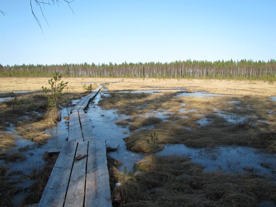
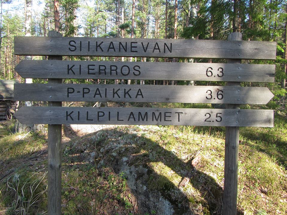
Kulje Siikanevan lenkki pisteestä N 61°49.790 E 024°12.194 (trailhead) pisteen N 61°49.638 E 024°09.123 (bogus) kautta pisteelle N 61°50.740 E 024°09.828 (trailhead) tai toisinpäin. Tee matkan aikana havaintoja ympäröivästä suomaisemasta.
a)
Kerro havaintojesi perusteella millaisia suotyyppejä Siikanevalla esiintyy. Selitä mahdollisimman yksityiskohtaisesti mihin tiettyihin yksityiskohtaisiin havaintoihin vastauksesi perustuu (pinnanmuodot, erityiset kohteet (tarkkojen tai arvioitujen koordinaattien kanssa), yms).
b)
Tee johtopäätöksiä kierroksen aikana näkemäsi perusteella, miksi ja miten suot ovat muodostuneet juuri tänne.
2 )
Pisteen N 61° 50.040 E 024° 11.496 (reference point) lähellä on meneillään yksi Siikanevan alueen monista tieteellisistä tutkimuksista liittyen soiden geologiaan.
a)
Selvitä miten kyseinen tutkimus liittyy soiden geologiaan? (vastaus löytyy osittain paikalta)
b)
Selitä miksi kyseinen tutkimus ja suot yleisesti ovat yhteiskunnallisesti merkitseviä?
3 )
Lähetä vastauksesi kätkön omistajalle vaikkapa tällä viestilinkillä tai sivun yläreunan viestikeskus linkin kautta.
Kirjoita viestin otsikoksi Siikaneva
(ps. jos valitset viestin alta "I want to send my email address along with this message" vastaamiseni helpottuu)
4 )
Sinun ei tarvitse odottaa loggauslupaa, mutta asiattomat logit tullaan poistamaan. Omistaja vastaa jollain aikavälillä viestiin, jos vastauksissa on epäselvää.
5 )
Toivottavaa mutta ei pakollista on myös että otat valokuvan itsestäsi ja/tai gps laitteestasi Siikanevalla ja liität se logiisi.
Siikaneva
Siikaneva mire is a large (approximately 1500 hectares) protected mire wilderness located in the municipalities of Ruovesi and Orivesi in southern Finland. Compared to many other mires, there is a lot of ecological and geological knowledge available from Siikaneva and it is important area for research and education. It is a natural mire complex which contains a variety of mire site types , rich mire birdlife, old natural forest islands as well as natural untouched landscapes.
Its peat layer contains all the post-glacial changes in the plant species diversity of the area indicating the history of the mire development and climate change. Furthermore, the mire reveals many historical signs of the former human culture and utilisation of the mires in Finland. Siikaneva provides also silence and recreation for a hiker, who can get familiarised with the mire area by walking on the route of duckboards and stop at the serviced shelters and fire places.
about restrictions for visitors at the area:
it is allowed to move at the area around year, (in Finnish):
http://www.luontoon.fi/retkikohteet/muutsuojelualueet/siikaneva/ohjeetjasaannot/Sivut/Default.aspx
Moving by foot and on skis is allowed altough We recommend staying on the path
Moving and right of public access is limited at surrounding private conservation areas.
For more information: Pirkanmaa Regional Environment Centre (www.ymparisto.fi).
to accomplish this cache visitors don't have to go to private conservation area.
Peat
Peat (turf) is an accumulation of partially decayed vegetation or organic matter that is unique to natural areas called peatlands or mires. The peatland ecosystem is the most efficient carbon sink on the planet because peatland plants capture the CO2 which is naturally released from the peat maintaining an equilibrium. In natural peatlands the "annual rate of biomass production is greater than the rate of decomposition" but it takes "thousands of years for peatlands to develop the deposits of 1.5 to 2.3 m, which is the average depth of the boreal peatlands." One of the most common components is Sphagnum moss, although many other plants can contribute. Soils that contain mostly peat are known as a histosol. Peat forms in wetland conditions, where flooding obstructs flows of oxygen from the atmosphere, slowing rates of decomposition.
Peatlands, also known as mires, particularly bogs, are the most important source of peat, but other less common wetland types also deposit peat, including fens, pocosins, and peat swamp forests. Other words for lands dominated by peat include moors, or muskegs. Landscapes covered in peat also have specific kinds of plants, particularly Sphagnum moss, Ericaceous shrubs, and sedges. Since organic matter accumulates over thousands of years, peat deposits also provide records of past vegetation and climates stored in plant remains, particularly pollen. Hence they allow humans to reconstruct past environments and changes in human land use.
Peat is harvested as an important source of fuel in certain parts of the world. By volume, there are about 4 trillion m³ of peat in the world covering a total of around 2% of global land area (about 3 million km²), containing about 8 billion terajoules of energy. Over time, the formation of peat is often the first step in the geological formation of other fossil fuels such as coal, particularly low grade coal such as lignite.
Finnish mires and some mire types
Mires are formed in areas where precipitation is high and evaporation low. A level substrate enables the lateral spread of the mires. The Finnish mires started to develop after the last deglaciation. In Finland, mire initiation has taken place in three different ways: forest paludification, lake terrestrialisation, and primary mire formation, referring to the spread of mire vegetation on a recently deglaciated soil or one that has emerged from the water as a consequence of post-glacial isostatic landuplift. Locally, river flooding may also have resulted in the initiation of mires.
Finland has more mires and peatlands regarding its land area than any country in the world; one third of its total land area is covered by them. Mires have always played an important role in Finn's lives, and they have been meticulously studied for over a hundred years.
Peatlands have been transformed into arable land, and forested mires are important to the forest industry. Furthermore, peat is economically valuable as a source of energy and growth medium as well as in environmental management. There are also various potential after-uses for abandonned peat production areas.
Various alternative forms of mire use are represented in the modern day, for example as tourist attractions and sites for sporting events, as well as a source of peat-based textiles and therapeutic products. Mires are also of importance to the Finnish arts, folklore and general state of mind. Responsible utilisation and conservation will secure the future of Finnish mires.
Mire types can roughly be divided in three different groups:
Pine mires: typical species pine (Pinus silvestris), cotton grass (Eriophorum vaginatum), arctic cloudberry (Rubus chamaemorus), many dwarf shrubs (like bog rosemary, Andromeda polifolia) and sphagnum-mosses (e.g. Sphagnum fuscum) etc. Usually poor, but there are some eutrophic pine mires (in Finn. = lettoräme), too.
Spruce mires: thriving usually close to the flowing water. Typical species spruce (Picea abies) and/or birch (Betula pubescens), bilberry (Vaccinium myrtillus) and herbaceous species, not so many dwarf shrubs than in pine mires, some sphagnum-mosses (like S. girgensohnii). Minerotrophic, not so poor than most of pine mires (and other ombrotrophic bogs). There are some eutrophic spruce mires (in Finn. = lehtokorpi, saniaiskorpi and ruoho- ja heikäkorpi).
Open mires (two groups):
- Open poor mires: treeless, usually dominated by different sedge (Carex) species (minerotrophic fens) or by Eriophorum species (ombrotrophic bogs).
- Eutrophic fens: richer in nutrients than other open mires, several herbaceous, Carex species and Bryales-mosses.
Aapa mire is a Finnish term for a large, complex, cold-climate wetland. More specifically, the aapa mire is a fen- or peatland which is supported by groundwater flow -with a very diverse array of internal features. Aapa mires typically have a mosaic of hummock-hollow topography, pools, and sedge lawns scattered about. Most aapa mires have some portion which is sloping, even if ever so slightly. This forces water to flow through the mire, as if a river. This creates surface patterning such as hummocks and hollows. Often, the distribution of hummocks and hollows is not random. They occur as parallel features of pool and ridges which are also known as flarks and strings. Sometimes the hummocks express themselves in a more random fashion. Some suspect that certain types of vegetation (mosses or Carex) or freeze-thaw processes may be a driver behind the development of these randomly occurring hummocks. The pools are thought to form when the water table raises above the surface of the mire long enough to kill the underlying vegetation. This creates a situation where peat is no longer being accumulated and, over time, essentially results in a 'hole' where pools occur.
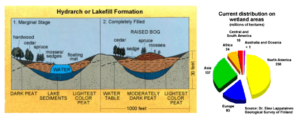
Raised bogs are found in lowland areas, generally below 150m, such as river valleys, lake-basins, and between drumlins. They are known as raised bogs because the bog surface is raised in the middle, like a dome. The surface of a raised bog is a mixture of pools, raised mossy hummocks and flatter lawns, and is colonised by plants and animals adapted to the acidic conditions and low levels of nutrients found there. This favours the growth of plants such as Heather, Cottongrasses and, most importantly, Sphagnum mosses. These plants die to form peat that is markedly different from fen peat and often very deep - up to 12m.
Raised bogs began to form in at the end of the last ice-age. They developed when the peat accumulating in fens became isolated from the groundwater. When the roots of raised bog plants lose contact with the groundwater, their only source of nutrients is from rainwater and the atmosphere.
To log this cache you must do following tasks in given coordinates:
1 )
Walk around Siikaneva mire path from coordinates N 61°49.790 E 024°12.194 (trailhead) via N 61°49.638 E 024°09.123 (bogus) to N 61°50.740 E 024°09.828 (trailhead) or another way. During this trip make observations about the mires around you.
a)
What kind of mire types there can be found from Siikaneva? Explain into what observations you specially base your opinion (special features (add exact or estimated coordinates to answer), shapes, etc). Be as detailed as possible.
b)
based on what you see during the route draw any conclusions why and how the mires has born just into this place?
2 ) Near the Coordinates N 61° 50.040 E 024° 11.496 (reference point) there is one of the Siikaneva areas many scientifical experimentation or measurement in progress.
a)
Find out on what phenomena related to mire geology this measurement is related to? (it is partly explained at the site)
b)
explain why this study and the mires in general are so important for whole society?
3 )
Send your answers (for example via this message link) to the cache owner.
Title your post “Siikaneva”
(ps. if you enable selction "I want to send my email address along with this message" it is easier for me to reply)
4 )
You don't have to wait for a logging permission, but any incomplete logs will be deleted. Cache owner will reply something for post if there is some faults in answers.
5 )
Is also desirable altough totally optional that you take a photo of yourself and/or your GPS device on the Siikaneva and attach it to you log.
kuva; joitakin suo tyyppejä:
picture; some mire types:
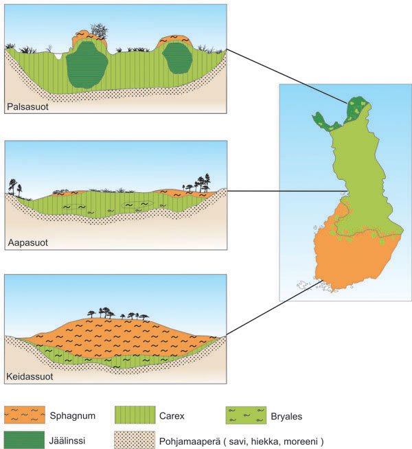
keidassuot = rised bogs
carex = sarat ; Bryales, Sphagnum = sammalet yms
Additional Hints
(No hints available.)