Rocklin is situated in the Great Valley, a geomorphic province of California. The valley sits on an alluvial plain 50 miles wide and about 400 miles long boarded by the Sierra Nevada and Coastal Ranges. The valley was formed by marine sediments left over from the receding ocean and was followed by river deposits washing down the Sierra Nevada, Klamath, Cascade, and Coastal mountain ranges.
Ancient Formations
The nearby Sierra Nevada range is a large fault block mostly comprised of hard rocks like granite and other metamorphic rocks. The rocks originated from a molten material called magma, miles below the Earth’s surface. As the material cooled several different minerals began to interweave together. This is called plutonic rock named after the Roman God of the underworld. Over millions of years, the Earth continued to spew magma which eventually formed plutons. Plutons are individual bodies of rock that were formed by magma that slowly cooled below the Earth’s surface. Today, many of these rocks are exposed at the surface.
In the valley, many of the plutonic rocks contain a wide variety of minerals. The most common are: quartz, feldspar (both potassium and plagioclase), biotite, and hornblende. These minerals are mainly comprised of the elements silicon, oxygen, and, with the exception of quartz, aluminum. In feldspar, potassium, sodium, and calcium can be found. In biotite and hornblende magnesium and iron are predominant.
The Plutons that comprise the Rocklin and Penryn area cover approximately 150 square miles. The extend from Folsom to Auburn. These rocks are typified as a light gray, coarsely-grained rock and comprised mostly of quartz, feldspar, hornblende, and biotite.
Bedrock geology:
Bedrock is the hard solid rock beneath the surface of the Earth. Bedrock is tightly bound, meaning it’s pretty solid. This is called a consolidated rock. an Unconsolidated rock is made up mostly of loose particles. Bedrock can extend hundreds of meters below the surface toward the Earth’s crust. The layers of bedrock are referred to as rockhead. The closer to the Earth’s surface, the more likely it is for the rockhead to be overlain with saprolite. Saprolite is bedrock that has undergone some form of weathering. Weathering is the process of wearing away layers of rock. The Saprolite has undergone forms of chemical weathering meaning that it has a completely different chemical composition from the other rock beneath it. Chemical weathering happens when water flows over the rock and interacts with the exposed minerals. Above the layer of Saprolite a layer of soil,sand, sediment, could be present.
Granite, the type of bedrock that comprises the Great Valley, looks light gray or white in color. A close examination will reveal many different colored crystals — white, gray, black, pink, etc. Minerals in this group include the Quartz (white, gray colored), feldspars (pinkish and white colored), hornblende (dark/black colored), and biotite (dark/black colored). The granite was formed out of mass of magma that cooled and crystallized over a period of 140 million years. During that time, the crust that contained the granite became uplifted. This is the reason the Sierra Nevada is slighted tilted at the summit leaning towards the Sacramento Valley. Meanwhile, the rock that was on top of the granite eroded away and became deposited in the Great Valley making the soil very mineral rich.
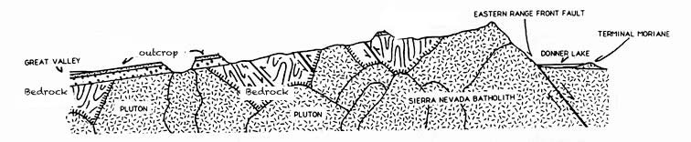
Today, exposed pieces of bedrock can be seen from the coastlines, to mountain tops, quarries, and on open plains. These visible exposures are called outcrops. Outcrops were often exposed to the surface by erosion. Erosion is the process where soil and rock from the surface of the Earth is worn away by the moving action of water, glaciers, wind, waves, even humans. Some were also due to tectonic uplift. Tectonic uplift is a process where the tectonic plates shift causing the elevation to increase. Drilling is another way that outcrops can be exposed. Outcrops allow for direction observation and sampling of the bedrock for many geological tasks including analysis, map surveys, building stability, bridge stabilization, etc. They are also help geologists understanding the geological timescale of the earth making them an invaluable resource.
To log this cache:
In an email please answer the following questions based on your own observations:
Do not post answers as part of your log, encrypted or otherwise, or it will be deleted!
- How many cachers are in your party?
- Based on what you have learned and what you observe, was this outcrop exposed by erosion, tectonic uplift, or deliberate drilling?
- Describe the characteristics of the rock: Is is hard or is it easy to break apart? Is it flat and fairly smooth or is it jagged and rough?
- Based on the prominent colors of this rock what mineral would you say is more dominant: feldspar, quartz, biotite, or hornblende
- Bonus Question: Do you think this rock has undergone a form of weathering or erosion? What kinds?
- Optional: Post a pic of yourself at the posted coords.
- Please don't post pictures of the rock
Got your answers? Click Here to email me
Don't wait for a reply to log it, I will typically only reply to incorrect answers and delete logs from users who did not send an email.
Sources:
- Wikipedia
- Sierra College Geology Department
- Encyclopedia Britannica
- National Park Service
- National Geographic
- California Geologic Survey
- USGS - Geologic Map Database
- National Park Service
|
|
Congrats to
LewisClan77 on their 600th FTF!!! |