Español
Localización:
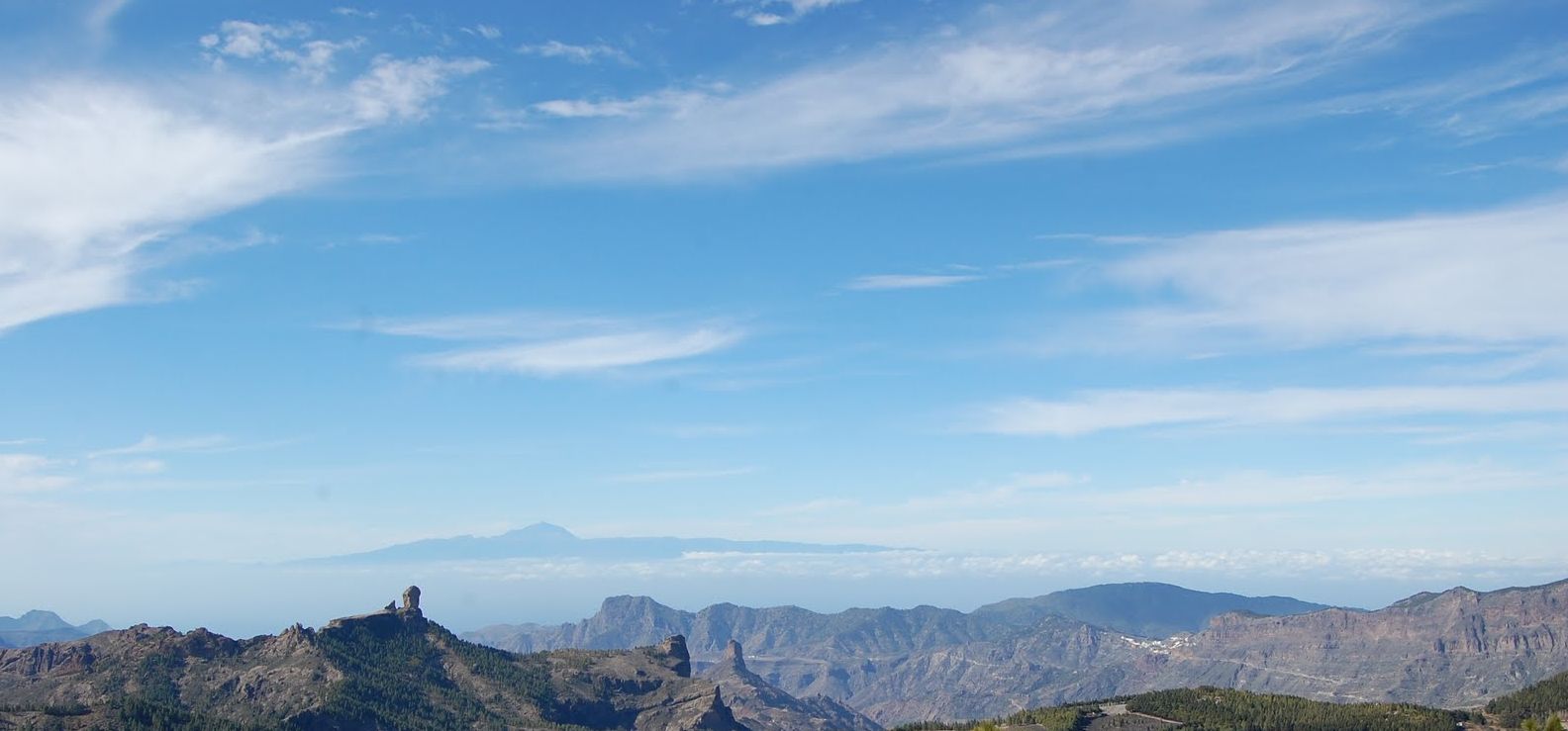
Con sus 1.949 metros de altitud sobre el nivel del mar (el mayor de Gran Canaria), está situado en el centro geográfico de la isla, justo en los límites de los municipios de San Bartolomé de Tirajana, Tejeda y Vega de San Mateo.
Historia Geologica:
La edad de la isla de Gran Canaria es de unos 14,5 millones de años. Es más joven que las orientales, pero más vieja que las occidentales. Su historia geológica se caracteriza por una continua alternancia de episodios eruptivos y de erosión. El resultado es un relieve muy accidentado desde la cumbre hasta el mar, a través de una red radial de barrancos.
Cronológicamente, la Isla se ha formado a lo largo de tres grandes ciclos eruptivos, intercalados por periodos de inactividad volcánica, durante los cuales han primado los procesos erosivos.

Durante el primer ciclo eruptivo, surge en un primer momento sobre el nivel del mar, una isla chata de poca altura. Este originario edificio se asienta sobre el complejo basal, fruto de erupciones submarinas que dan lugar al basamento insular. Las erupciones volcánicas siguen sucediéndose de manera intensa, lo que va a propiciar que el edificio central crezca de manera importante, creándose el primitivo escudo insular. Al mismo tiempo, la gran emisión de materiales volcánicos provoca el vaciamiento de la cámara magmática de este edificio central, lo que da pie al colapso del mismo y a la generación de una caldera por hundimiento, la conocida como Paleocaldera de Tejeda. La reanudación de la actividad volcánica hace que esta caldera se rellene, rebosando los materiales volcánicos y cubriendo los basaltos antiguos. El resultado de este primer ciclo eruptivo es la formación de una Isla de perímetro más o menos circular, con sus mayores alturas desplazadas hacia el oeste.
El segundo ciclo eruptivo comienza tras un largo periodo de inactividad volcánica donde la erosión hace mella sobre el relieve insular, excavando profundos barrancos sobre las rampas lávicas y generando acantilados por la acción del mar. Esta actividad erosiva y posterior transporte de los materiales a través de los barrancos, generan importantes depósitos sedimentarios, destacando principalmente el de Las Palmas, en el noreste, y el de Arguineguín, en el sur.
Durante este segundo ciclo, también conocido como ciclo Roque Nublo, los centros eruptivos se concentraron el centro de la Isla, en lugares como Ayacata, La Culata de Tejeda, Las Mesas y Tenteniguada. Fue una fase de violentas erupciones que generaron el gran estratovolcán del Roque Nublo, edificio que fue víctima de sus propias violentas manifestaciones, dando lugar a su desestructuración y posterior deslizamiento de materiales hacia suroeste.
Por último está el tercer ciclo eruptivo, precedido nuevamente de un periodo de inactividad volcánica. Se siguen produciendo procesos erosivos y se vuelve a formar la Caldera de Tejeda. Esta vez no por el derrumbamiento del edificio volcánico, sino por la erosión y el desalojo de los materiales.
La actividad de este ciclo se concentra casi exclusivamente en la mitad norte de la Isla, dando lugar a la aparición de nuevas formaciones volcánicas de carácter puntual. Algunos ejemplos pueden ser la Caldera de Bandama, Montaña de Arucas, la de Arinaga y la Montaña de Galdar, también conocida como Montaña de Ajódar o La Atalaya.
A partir de aquí, ha sido nuevamente la erosión continuada la que ha ido modelando el territorio, ya que, al contrario que otras islas como Lanzarote, Tenerife o La Palma, en Gran Canaria no ha vuelto a haber ninguna actividad volcánica después de la época cuaternaria.
Para logar este EarthCache, envíame un correo electrónico con la respuesta a las siguientes preguntas:
1) ¿En que ciclo se formo el Pico de las Nieves?
2) ¿Cual es el origen del paisaje frente a usted, y cual ha sido el "proceso principal" que ha intervenido en su forma actual?
3) Viendo el panel informativo, ¿Quien es el autor del primer parrafo? ¿Que vehiculo hay en una foto del panel? ¿Que construcción hay sobre una roca a 6 metros por detras?
4) Añade una fotografia tuya en log, u otra en la que se pueda ver algún objeto, o tu nick en un papel
-Si crees que as concluido con exito los objetivos de este Earth Cache, y me ha enviado todas las respuestas solicitadas, puede hacer el log. Luego yo comprobaré que son correctas, y si hay cualquier problema me pondre en contacto para arreglarlo.
-Logs sin respuestas enviadas previamente, seran borrados sin aviso
English
Location:
With its 1,949 meters of altitude above sea level (Gran Canaria´s top), it´s located in center geographic of the island, just in the limits of the municipalities of San Bartholomé de Tirajana, Tejeda and Vega de San Mateo.
Geologic History:
The age of the island of "Gran Canaria" is of about 14.5 million years. It is younger than Eastern islands, but older than the western ones. Its geologic history is characterized by a continuous swapping of eruptive episodes and erosion. The result is a very rough relief from the summit to the sea, through a radial network of precipices.
Chronological, the Island has formed throughout three great eruptive cycles, followed by periods of volcanic inactivity, during which the erosive processes are primate.
During the first eruptive cycle, arise at a first moment on the level of the sea, a flat island of little height. This original building is based on the basal complex, source of submarine eruptions that give rise to the insular plinth. The volcanic eruptions continue following one another of intense way, which is going to cause that the central building grows of important way, being created the primitive insular shield. At the same time, the great emission of volcanic materials causes the evacuating of the magmatic camera of this central building, which gives foot to the collapse of he himself and the generation of a boiler by collapse, well-known like "Paleocaldera de Tejeda". The renewal of the volcanic activity causes that this caldera fills up, overflowing the volcanic materials and covering old basalts. The result of this first eruptive cycle is the formation of an Island of more or less circular perimeter, with its greater heights moved towards the west.
The second eruptive cycle begins after a long period of volcanic inactivity where the erosion makes notch on the insular relief, excavating deep precipices on the lava ramps and generating cliffs by the action of the sea. This erosive activity and later transport of the materials through the precipices, generates important sedimentary deposits, emphasizing mainly at "Las Palmas", in the northeast, and the one of Arguineguín, in the south.
During this second cycle, also known like Cycle Roque Nublo, the eruptives centers was concentrated at the center of the Island, in places like Ayacata, "La culata de Tejeda", Mesas and Tenteniguada. It was a phase of violent eruptions that generated the great estratovolcán of the Roque Nublo, building that was victim of its own violent manifestations, giving rise to its desestructuración and later sliding of materials towards southwest.
Finally it is the third eruptive cycle, preceded again of a period of volcanic inactivity. They are continued producing erosive processes and one becomes to form the "Caldera deTejeda". This time not by the collapse of the volcanic building, but by the erosion and the evacuation of the materials.
The activity of this cycle almost exclusively concentrates in North half of the Island, giving rise new to the volcanic appearance of formation of precise character. Some examples can be the "Caldera de Bandama", Mountain of Arucas, the one of Arinaga and the Mountain of Galdar, also well-known like Mountain of Ajódar or the "La Atalaya".
From here, it has been again the continued erosion the one that has been modeling the territory, since, on the contrary that other islands like Lanzarote, Tenerife or La Palma, in "Gran Canaria" have not returned to have volcanic activity after the quaternary time.
To log this earthcache, send me an email with the answer to the following questions:
1) In which cycle was created the "Pico de las Nieves"?
2) What is the origin of the landscape in front of you, and what has been the “main process” that has formed it?
3) Look at the information board, Who is the first paragraph´s autor? What vehicle it´s photographed at the information board ? There is construction 6 mtrs behind you, over a rock, What it´s ?
4) Add a photo of yourself in log, or another in which you can see an object, or your nick on a piece of paper
-If you believe you have successfully completed this Earth Cache goals and has already sent to me all the requirements as requested, Please, feel free to log it as found. Later i will verify the requirements sent and, if necessary, contact you in order to make the necessary corrections to your log.
-Logs without answers, will be deleted without notice.
