Jūrkalnes Stāvkrasts EarthCache
-
Difficulty:
-

-
Terrain:
-
Size:  (not chosen)
Please note Use of geocaching.com services is subject to the terms and conditions
in our disclaimer.
( Lv - Jūras stāvkrasts pie Jūrkalnes / En - See cliff near Jūrkalne )
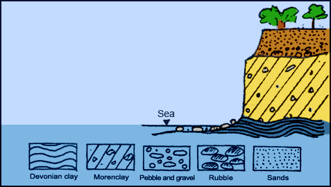
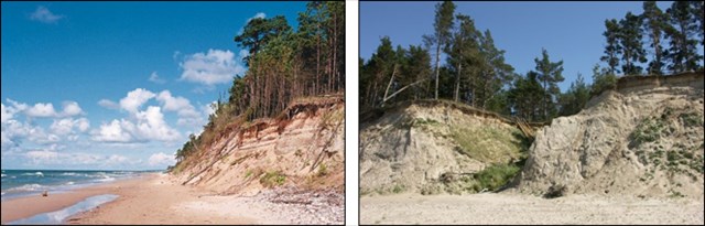
 STĀVKRASTS
Piekrastē, kur ilgstoši dabisko procesu vai antropogēno aktivitāšu ietekmē (ostas ar hidrotehniskajām būvēm) jūra uzvirzās augstāk paceltajām piejūras teritorijām, tās vētru laikā sistemātiski noskalojot, izveidojas jūras stāvkrasti. Stāvkrastos atsedzas dažādas ģenēzes kvartara nogulumieži (ledāja un tā kušanas ūdeņu, jūras, eolie) vai relatīvi cietākie, grūtāk erodējamie pamatieži. Latvijas piekrastes stāvkrastos izplatīti ir tikai devona smilšakmeņi, māli un aleirolīti. Latvijas piekrastē jūras stāvkrastu slīpumi ir robežās no 30° līdz 70°. Visievērojamākie un ainaviski, kā arī ģeoloģiski interesantākie un iespaidīgākie ir augstie un vidēji augstie stāvkrasti ar sarežgītu ģeoloģisko uzbūvi. Tie sastopami vietās, kur jūra ilgstoši, gadu tūkstošiem, erodē pamatkrastu un pakāpeniski uzvirzās sauzemei. Visspilgtākā un vistipiskākā ir stāvkrasta josla, kas sākas uz ziemeļiem no Pāvilostas un, ietverot Ulmali un Jūrkalni, ap 24 km garumā stiepjas līdz Sarnātei, bet ar pārtraukumiem līdz pat Užavas bākai. Nepārtraukto, vidēji, līdz 10-15 m (maksimāli 20 m) augsto stāvkrastu sašķeļ nelielo upju (Rīva, Enava, Muižupīte u.c.) ielejas un īsas V-veida gravas. Jūrkalnē atrodas aktīvs noslīdeņu - nogruvumu tipa stāvkrasts. Arī vislielākā krasta erozija ir novērojama tieši pie Jūrkalnes. Tieši no Jūrkalnes apkārtnes ir izskalots tik pat daudz, cik visā Latvijā kopumā.
UZDEVUMS
Lai pielogotu šo slēpni kā atrastu, Jums ir jāapmeklē Jūrkalnes stāvkrastu, jānoskaidro atbildes uz zemāk dotajiem jautājumiem un jāatsūta tās man uz e-pastu! Savam logam nekādā gadījumā nepievienojiet atbildes!
• Izskalotie jūras stāvkrasti paver lielisku iespēju aplūkot dažādus augsnes slāņus. Raksturo šo slāņu skaitu un sastāvu!
• Vai pastāv iespēja, ka jūras viļņi varētu izskalot pazemes alas stāvkrastos? Pamato savu viedokli ar ģeoloģiskiem faktiem!
• Dažādās vietās stāvkrastu augstums un sastāvs ir atšķirīgs. Kādas ģeoloģiskas atšķirības ir vērojamas dotajos punktos?

 Pats interesantākais veids, kā iepazīt mūsu planētu un tās procesus, ir doties ārā un gūt pieredzi pašam uz savas ādas. EarthCache sniedz lielisku iespēju savu brīvo laiku pavadīt ārpus mājām kopā ar ģimeni, apgūstot šo un to interesantu par to, kā ir veidojusies mūsu planēta daudzu gadsimtu garumā. Nekavējieties ne mirkli un dodieties ceļā! Lai uzzinātu vairāk par EarthCache, spiediet ŠEIT !
 SEA CLIFF
On coasts where natural or anthropogenic (ports with hydrotechnical structures) processes cause sea to move onto high lifted coast lines by washing down them sistematically during storms seashore cliffs are formed. On seashore cliffs sedimentary rocks of different genesis (glacial, marine, eolic) or harder, more difficult to erode bedrocks are uncovered. On Latvian seashore cliffs only Devonian sandstones, clays and aleirolites are present. On Latvian shorelines seashore cliffs are in angle from 30 to 70 degrees. Most spectacular and most scenic as well as most interesting geologically are high and midle high seashore cliffs with complicated geological structure. They are formed in places where sea is eroding shore line systematically in period of thousands of years gradually moving onto the shore land. Most significant and most typical is seashore cliffs zone that starts from Pavilosta and including Ulmale and Jurkalne stretches to Sarnate (approximately 24 km) and with some interuptions even to the Uzava lighthouse. Continuous, 10 to 15 meters (maximum 20) high seashore cliff is split by walleys of small rivers (Riva, Enava, Muizupite) and short V-type ravines. In Jurkalne active landslide- landslip type seashore cliff can be found. Biggest coast erosion can also be found near Jurkalne. From vicinity of Jurkalne the same amount of shore line is washed out as from all coast line in Latvia totally.
THE TASK
To log this earthcache as found, you must visit Jūrkalne`s sea cliff and find answers to given questions below. Send them to my e-mail! Don`t add the answers to your log!
• This sea cliff gives you an opportunity to look at the layers of the ground. Count them and describe their structure!
• Is there a possibility that sea waves here can erode underground caves? Argue your opinion with geological facts!
• What kind of geological differences of cliff structure you can observe in these three given waypoints?
The most interesting way, how to explore our planet and its processes is to go out and gain experience. EarthCache gives you an excellent opportunity to spend your free time with your family out of the home, lerning so much interesting about how our planet has been formed for many centuries. What are you waiting for? Go out for an adventure! To get more information about EarthCache - press HERE !
Information Source: Latvia.Travel & "Latvijas Jūras Krasti" & Wikipedia
Additional Hints
(No hints available.)