[Ro]
Diviziunile geografice (continente, țări, județe, localități, ...) au un punct considerat a fi centrul lor. Pentru localități acesta este punctul din care se măsoară distanțele sau se numerotează străzile: din centru spre exterior, numerele pare pe dreapta, numerele impare pe stânga (excepție fac piețele).
M-am întrebat unde o fi punctul din centrul Clujului? Am presupus că este suficient să caut pe o hartă digitală "Cluj-Napoca" și să aflu coordonatele. Căutând pe 11 hărți am gasit 10 puncte diferite, înșirate de la Primărie până la Prefectură sau chiar mai departe (vezi Google Earth...).
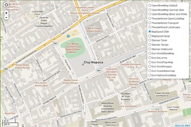
Locul de unde începe numerotarea străzilor din Cluj este Piața Unirii. Deși nu este marcat în nici un fel, putem presupune că Centrul Clujului este în centrul acestei piețe, aproximativ acolo unde este pus pe harta MapQuest OSM.
Din motive de proximitate nu am putut să pun o cutie chiar în acest loc, dar ea nu este ascunsă prea departe. La coordonatele de start al acestui mystery veți găsi un "punct de nivelment". Fantele de deasupra sunt îndreptate spre cele patru puncte cardinale. Pe placa metalică din lateral sunt inscripționate două rânduri de text:
- rândul de sus are un singur carater (I, adică unu roman) pentru că acest punct de nivelment este primul dintr-un șir lung de puncte, fiind cel mai aproape de centru;
- pe rândul de jos veți găsi un număr care reprezintă altitudinea punctului de nivelment, determinat la milimetru: ABC.DEF
Coordonatele finale sunt:
N46 46.(E-F)(B+D)C; E023 35.(E-B)(C-F)A
Atenție: datorită clădirilor înalte din apropierea coordonatelor finale, recepția semnalelor GPS este slabă!
[En]
Geographic divisions (continents, countries, counties, towns etc.) have a point considered to be in their centre. For towns this is the point from which distances are measured or streets are numbered: from the centre out, even numbers on the right, odd numbers on the left (markets are excepted).
I asked myself where would the centre of Cluj be? I presumed it was enough to search on a digital map "Cluj-Napoca" to find the coordinates. Searching on 11 maps I found 10 different points, enumerated from the City Hall towards the Prefecture or even farther (see Google Earth...).
The place from where the street numbering starts in Cluj is the Union Square ("Piața Unirii"). Although there is no sign of any kind, we can assume that the Center of Cluj is in the center of this square, approximately where the MapQuest OSM map indicates.
Because of proximity reasons I could not place a cache at this location, however it is not hidden far. At the start coordinates of this mystery you will find a topographic marker. The slits on the top are pointed towards each cardinal point. There are a two lines of text on the metallic plate found on the side of this marker:
- on the first line you will find only one character (I, the roman numeric symbol for 1) because this is the first topographic marker in a long series. It is also the closest to the center;
- on the second line you will find a number that represents the altitude of the topographic marker calculated with the precision of a millimeter: ABC.DEF
The final coordinates are:
N46 46.(E-F)(B+D)C; E023 35.(E-B)(C-F)A
Note: because of the tall buildings near by the final coordinates, reception of GPS signals is weak!