Dansk:
Dette er en Earthcache og der er derfor ingen fysisk log at skrive i. Svar på spørgsmålene i din logning på geocaching.com og i den mail du skal sende til mig. God jagt.
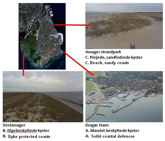
Amagers kyster bærer præg af at være menneskeskabte og kunstige. Når man bevæger sig rundt på øen møder man de meget vekslende kysttyper der kan inddeles i 4 typer:
A. Massivt beskyttede kyster
Disse kyster udgør hovedparten af øens kyster i dag. De fleste vil nok ikke kalde dem for egentlige kyster, idet der er tale om kaj- og havneanlæg og massive stensætninger. Formålet med kysterne er at beskytte områder mod erosion. Vi ser bl.a. kysterne i Københavns havn, rundt om lufthavnen etc. Denne kysttype er altdominerende på de nordlige og østlige dele af øen.
B. Digebeskyttede kyster
Disse kyster er meget dominerende i den sydlige og vestlige del af øen. Som navnet siger, så udgøres kysten af diger, nogle steder med en stedbræmme foran diget. Vi ser diger omkring Amager fælled, og på sydkyster på strækningerne mellem Dragør og Søvang. Nogle steder er digerne meget tilgroede og der er opstået Tilgronings- og strandengskyst foran diget (se nedenfor)
C. Plejede, sandfodrede kyster
Disse kyster ser vi ved Amagerstrandpark, men også i mindre omfang lige syd for Dragør by. Ved Amagerstrandpark er kysten suppleret med kunstigt anlagte klitter. Her er formålet klar: at lave rekreative tilbud for byens borgere.
D. Naturlige kyster
Denne sidste type af kyst findes i flere varianter, men for Amager er der tale om 2 kysttyper:
i) Tilgronings- og strandengskyster.
Disse kyster findes i meget begrænset omfang på det sydlige Amager. Dels foran digerne ved Søvang og dels på mindre strækning rundt omkring på det sydlige Amager. Kysterne er kendetegnede ved meget lavt vand med rørskove. Typisk ligger kysten i læ af andre kyststrækninger.
ii) Barrierekyster
Dette er den type af kyst som man ser her på Dragør sydstrand – og det er emnet for denne cache. Som navnet siger så er der tale om at havet foran den gamle kyst danner ny kyst parrallet med den gamle. Bag den nye kyst efterlades den gamle strand som et vådområde med begrænset eller ingen adgang til havet. En lignende kyst ser man på Amagers aller sydligste punkt.
Barrierekyster
En barrierekyst dannes af havet, hvor kysten har en profil med en lav hældning. Når der samtidig er et overskud af løst materiale i havet, der enten tilføres ude fra dybere vand eller med strømmen langs med kysten, da opstår muligheden for dannelsen af Barrierekyster. Med løst materiale forestås sand, grus og tang. På det lave vand danner havets bølger revler ved at hvirvle det løste materiale op. Hvis dette kombineres med ekstraordinær højvande og storme, da kan der dannes strandvolde der er over normal vandstand. Hermed har havet dannet starten til en barrierekyst. Efterfølgende øges kysten ved klitdannelse og vegetation.
Ofte vil havet både danne og fjerne barrierekysten. Men, som her ved Dragør, kan det ende med at den nye barrierekyst bliver liggende. Nogle år dannes der små revler og øer ud fra kysten, der efterfølgende forsvinder igen.
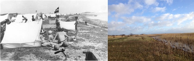
Samme sted med 80 års mellemrum.
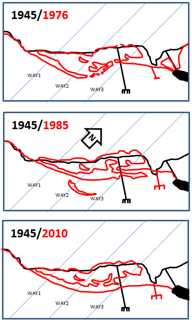
Udviklingen ved Dragør siden 1945
Når du ser på udviklingen siden 1945, opdager du at kysten er meget ung. Mellem 1945 og 1976 blev barrieren opbygget, og siden da har den lukket sig, sådan at vådområdet i dag næsten ingen forbindelse har til havet.
I 1985 havde havet lavet starten til en ny barriere kyst endnu længere ude. Den er dog forsvundet igen. På den måde kan små øer og barriere komme og gå over tid.
Se kortet på historiskatlas.dk
-> vælg menupunktet "værktøjer" -> "tidslup"
Se tidligere hvordan kystlinien har ændret sig baseret på logninger af denne cache (spm 4): KLIK her
Opgaverne:
Følgende skal du skrive i din mail til mig:
Opgave 1:
Når du står på startkoordinatet: Bevæg dig ned på indersiden af barrierekysten helt ned til rørskoven. Hvordan vil du beskrive jordenbunden her og hvordan er den blevet som den er? Beskriv med dine egne ord hvordan du tror rørskoven ændrer landskabet bag barrierkysten.
Opgave 2:
Når du står på startkoordinatet: Bevæg dig nu ned på ydersiden af barrierekysten - helt ned til vandkanten. Hvordan vil du beskrive sandet på stranden 1-2 meter før vandlinien og umiddelbart ½ meter ude i vandet? Beskriv med dine egne ord hvor finkortet sandet er over og under vandlinien.
Opgave 3:
Når du står på startkoordinatet: Hvor meget vil du vurdere det højeste punkt her til at være over vandlinien?
Følgende er du meget velkommen til at skrive i din log på geocaching.com, men det er helt frivilligt:
OPGAVE 4 [FRIVILLIGT]: Geologerne følger år efter år strandens udvikling. LAD OS HJÆLPE DEM. Går til følgende E-koordinater. Hvad er N når du står præcis i vandkanten?
WAY1: N 55° 34.8xx E 012° 39.750
WAY2: N 55° 34.9yy E 012° 40.000
WAY3: N 55° 35.0zz E 012° 40.250
Det kunne være sjovt om du i din logning angive de 3 waypoints. Over tid vil man i denne cache kunne følge kystens bevægelser på baggrund af dine og andres waypoints.
Opgave 5 [FRIVILLIGT]: På WAY_DYBDE N 55° 34.950 E 012° 40.000, hvor dybt er vandet?
Opgave 6 [FRIVILLIGT]: Tag et eller flere billeder fra området med kysten som tema.
Opgave 7 [FRIVILLIGT]:
Når du står ved WAY2: N 55° 34.9yy E 012° 40.000: hvor langt er der til kystlinien anno 1945? Kysten er markeret i opgaven som WAY_1945: N55 35.090 E 012° 39.850
English:
This is an Earth Cache and therefore there is no physical logbook to write in. Answer the questions in your log on geocaching.com and in the mail you send to me. Happy hunting. Many thanks to "den sure kalkun" fore the help on translation of this cache.
Most of Amager's coastline is characterised by being man-made and artificial. When travelling around the island, you see various types of coast which can be divided into 4 types:
A. Solid coastal defences
These shores comprise the majority of the island's coast today. Most people would not call them real shorelines; they comprise harbour and port facilities and massive stone blocks. The purpose of these coasts is to protect the land from erosion. We see these coasts in Copenhagen harbour, around the airport, etc. This coastal type is predominant in the northern and eastern parts of the island.
B. Dyke protected coasts
These shores are dominant in the southern and western parts of the island. As the name says the coast comprises dykes, in some places with a stone fringe in front of them. We see dykes around Amager Common, and on the south coast between Dragør and Søvang. In some places the dykes are very overgrown and the shore is advancing; beach coasts have formed in front of the dyke (see below)
C. Beach, sandy coasts
These shores are seen near Amagerstrandpark, and to a lesser extent just south of Dragør town. At Amagerstrandpark it is supplemented with artificial dunes. The aim here is clear: to create recreational areas for local citizens.
D. Natural coasts
This last type of coast come in several flavours, but on Amager these are two coastal types:
i) Vegetated coast or saltmarsh..
These coasts are very limited on the southern island of Amager. Firstly, in front of the dykes at Søvang and partly on less-visited parts of southern Amager. The coasts are characterized by very shallow water with reed beds. Typically this type of coastline is sheltered by other shorelines.
ii) Barrier coastal system
This is the type of coast seen here on Dragør's southern beach and is the subject of this cache. In this case, the sea in front of the old coast creates a new coast parallel with the old one. Behind the coast the old beach is left as a wetland with limited or no access to the sea. A similar coast can be seen at Amager's most southerly point.
Barrier coastal system
A barrier coastal system is formed by the sea where the coast has a profile with a shallow slope. When accompanied by an excess of loose material in the ocean, which is either supplied from deeper water or downstream along the coast, the opportunity arises for the formation of a barrier coastal system. The loose material is sand, gravel and seaweed. In the shallow water the ocean waves deposit this loose material to form sand bars. If this is combined with extraordinary high tides and storms, beach ridges above the normal high water level can form. In this way, the sea will have created the beginning of a barrier coastal system. Subsequently the coast advances through dune formation and vegetation.
Often the sea both creates and destroys a barrier coast. But, like here at Dragør, it may end up with the formation of a new barrier coast. Some years small sandbanks and islands form off the coast which subsequently disappear.
Same place - 80 years apart.
Developments near Dragør since 1945
When you look at the development since 1945, you discover that the coast is very young. Between 1945 and 1976 the spit grew, and since then it has closed itself so that the wetland today has almost no connection to the sea.
In 1985, a new barrier started to form even further out. However, it is gone again. In this way, small islands and barriers come and go over time.
See the map on historiskatlas.dk
-> choose "værktøjer" -> "tidslup" from the menu
Tasks:
The following should be written in an email to me:
Task 1:
While on the start coordinates: Walk down the inside of the barrier coast towards the reed beds . How would you describe the soil here and how has it become that way? Describe in your own words how you think reed beds are changing the landscape behind the barrier coast.
Task 2:
From the start coordinates: Carry on down the outside of the barrier coast - right down to the water's edge. How would you describe the sand on the beach 1-2 meters before the water line and immediately ½ meter out to sea? Describe in your own words how fine-grained sand is above and below the waterline.
Task 3:
From the start coordinates: Estimate the elevation of the highest point here above the waterline?
You are welcome to write the following in your log on the cache page – but it is voluntary:
Task 4 [voluntary]: Geologists track the beach’s yearly development. WE CAN HELP. Go to the following E- coordinates. What is N when you are standing just at the water’s edge?
WAY1: N 55° 34.8xx E 012° 39.750
WAY2: N 55° 34.9yy E 012° 40.000
WAY3: N 55° 35.0zz E 012° 40.250
It might be fun for you to list these three waypoints in your logs. Over time we can follow the coast’s movements in this cache, based on your and others' waypoints.
Task 5 [voluntary]: AtWAY_DYBDE N 55° 34.950 E 012° 40.000, how deep is the water?
Task 6 [voluntary]: Take one or more pictures of the area with ‘coast’ as a theme.
Task 7 [voluntary]:
Standing at WAY2: N 55° 34.9yy E 012° 40.000: how far is it to the coastline as it was in 1945? The coast is marked as WAY_1945: N55 35.090 E 012° 39.850