Tato multina - Malé vodní elektrárny v Praze - nepatří zrovna k těm kratším. Protáhne vás skoro celou Prahou od severu k jihu a jen vzdušnou čarou je dlouhá cca 12 km. Takže s různými zajížďkami těch km bude o něco víc.
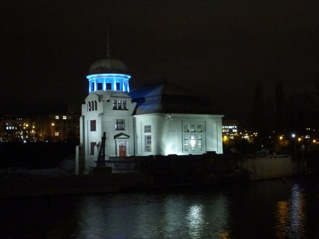
PODBABA
V Praze na Vltavě byla spuštěna čtvrtá vodní elektrárna. Po té v Modřanech, na Štvanici a v Podbabě byla otevřena také malá vodní elektrárna na Císařském ostrově v Troji. Ročně má vyrobit energii, která by vystačila pro pět tisíc domácností.
Vodní dílo Trója – Podbaba bylo postaveno díky práci „Komise pro kanalisování Vltavy a Labe v Čechách“ v letech 1899 – 1902. Dílo původně tvořil hradlový jez o třech polích, horní plavební kanál, plavební komory v Podbabě a dolní plavební kanál.
V roce 1979 byl hradlový jez nahrazen modernějším pohyblivým jezem. Všechna tři pole jsou v současné době hrazena ocelovými klapkami s maximální hradící výškou 3,3m. V každém ze tří polí jsou umístěny dvě klapky. Při pravém břehu vedle jezu byla situována vorová propust, která je v současnosti využívána jako sportovní slalomová dráha. Na levém břehu je u velínu jezu umístěna malá vodní elektrárna dokončená v roce 2009. Elektrárna je osazena dvěma přímoproudými Kaplanovými turbinami s celkovým dosažitelným výkonem 1960 kW.
Vlevo od elektrárny je vjezd do 3 km dlouhého plavebního kanálu k plavebním komorám v Podbabě. Výstavba plavebních komor se datuje léty 1899 – 1902. Plavební komory jsou umístěny vedle sebe a jejich technologie se během různých modernizací měnila. V současné době je velká plavební komora napouštěna poklopovými „Čábelkovými“ vraty sklopnými proti vodě a vypouštěna stavidly ve vzpěrných vratech na dolním ohlaví. Malá plavební komora je plněna i prázdněna obtoky. Na horním ohlaví je komora osazena klapkovými vraty. Na dolním ohlaví malé komory jsou vrata vzpěrná. Při nedávné rekonstrukci malé komory bylo nalezeno pouzdro s historickým svědectvím o návštěvě císaře Františka Josefa I. na stavbě tohoto vodního díla.
Od roku 1995 je na plavební komoře v provozu malá vodní elektrárna. Dvě Kaplanovy přímoproudé turbíny jsou umístěny do bočních zdí velké plavební komory.
/EN/
This multina - Small hydro power plants in Prague - is not exactly one of the shorter ones. It will stretch you through almost the whole of Prague from north to south and only as the crow flies is about 12 km long. So there will be a little more with the various detours of those kilometers.
PODBABA
A fourth hydroelectric power plant has been launched in Prague on the Vltava. After that, a small hydroelectric power plant was opened on Modřany, Štvanice and Podbaba on Císařský ostrov in Troja. It is supposed to produce enough energy for five thousand households a year.
The Troja-Podbaba waterworks was built thanks to the work of the "Commission for Sewerage of the Vltava and Elbe in Bohemia" in the years 1899 - 1902. The work originally consisted of a three-field gate weir, the upper navigation channel, the navigation chambers in Podbaba and the lower canal.
In 1979, the gate weir was replaced by a more modern moving weir. All three fields are currently covered by steel flaps with a maximum barrier height of 3.3 m. There are two flaps in each of the three fields. At the right bank next to the weir was situated a raft culvert, which is currently used as a sports slalom track. On the left bank, next to the weir control room, there is a small hydroelectric power plant completed in 2009. The power plant is equipped with two direct-current Kaplan turbines with a total achievable power of 1960 kW.
To the left of the power plant is the entrance to the 3 km long canal to the locks in Podbaba. The construction of the locks dates back to 1899 - 1902. The locks are located next to each other and their technology has changed during various modernizations. At present, the large navigation chamber is filled with a hinged "Čábelková" door that tilts against the water and is emptied by sluices in the retaining door on the lower head. The small lock is filled and emptied with bypasses. The chamber is fitted with a flap door on the upper head. The gate is on the lower head of the small chamber. During the recent reconstruction of the small chamber, a case was found with historical evidence of the visit of Emperor Francis Joseph I to the construction of this waterworks.
Since 1995, a small hydroelectric plant has been in operation at the lock chamber. Two Kaplan direct current turbines are located in the side walls of the large lock chamber.
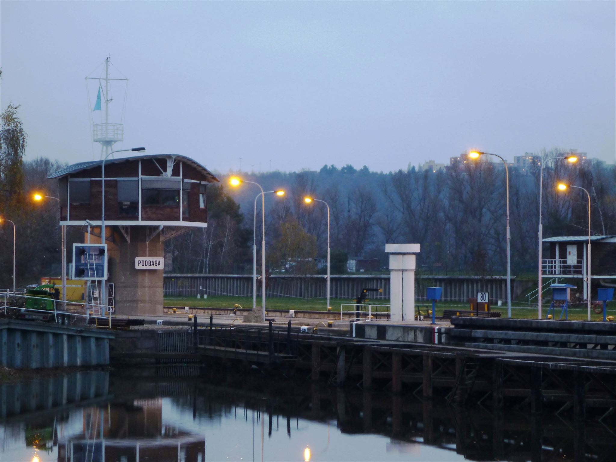
Část vodního díla Podbaba s velínem.
Part of the Podbaba waterworks with a control room.
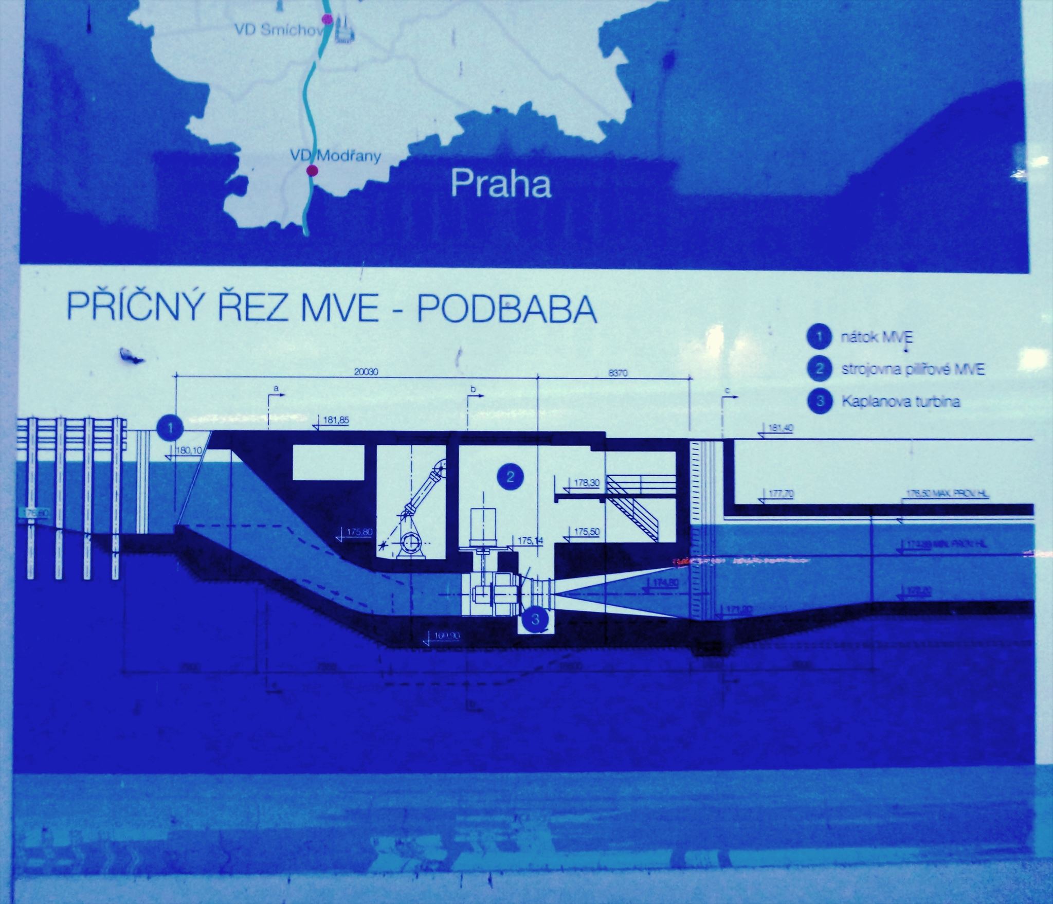
Detail malé vodní elektrárny v řezu.
Detail of a small hydroelectric plant in section.
Nejsem sice moc příznivcem různého počítání, ale nějak se k těm finálním souřadnicím dostat musíme.
Stage č.1
Na výchozích souřadnicích stojíte před informační tabulí Povodí Vltavy.
N 50°06.949
E 014°23.585
Na této tabuli je na jednom černobílém fotu plavba voru. Na tom voru se plaví A vorařů.
Na té samé tabuli spočítejte, kolik je na mapce Závodů (jsou vyznačeny červeně) a budete mít B.
Později přijde na řadu i ciferace. Co je ciferace jistě všichni znáte, ale pro úplnost je tu příklad:
12345=1+2+3+4+5=15=1+5=6 výsledné číslo je 6
I'm not a big fan of various calculations, but somehow we have to get to those final coordinates.
Stage # 1
In front of the default coordinates, you are in front of the Vltava River Basin information board.
N 50 ° 06.949
E 014 ° 23.585
On this board, one black and white photo shows a raft sailing. On that raft A rafters are sailing.
On the same board, count how many Races there are on the map (they are marked in red) and you will have B.
Digitization will come later. Surely you all know what digitization is, but for completeness here is an example:
12345 = 1 + 2 + 3 + 4 + 5 = 15 = 1 + 5 = 6 the resulting number is 6
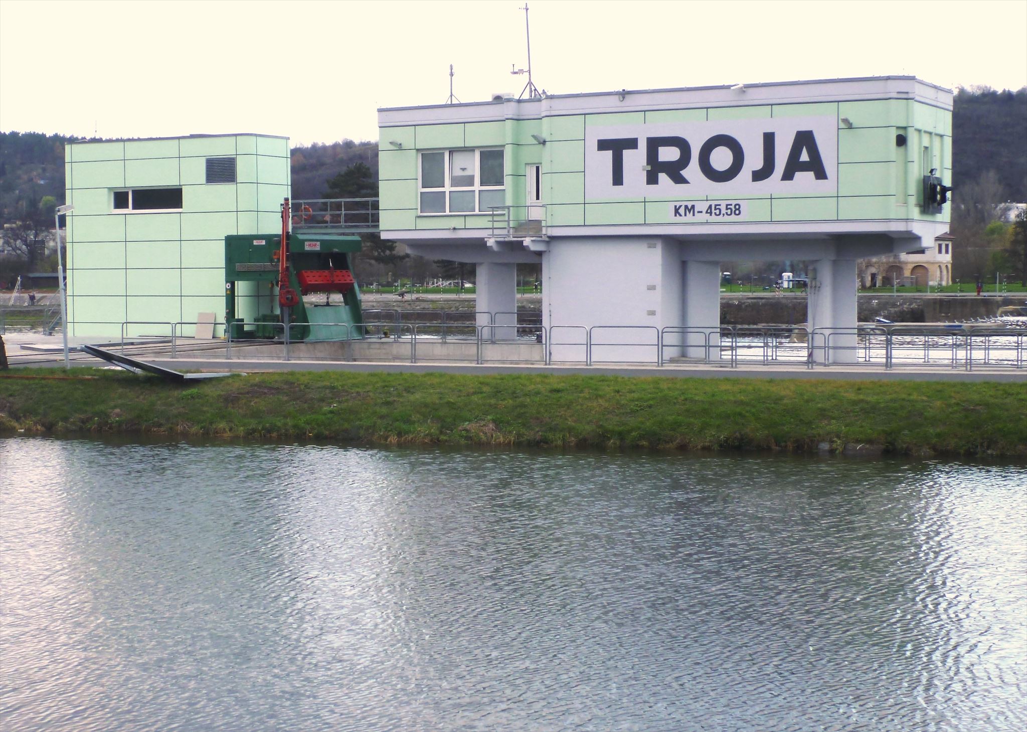
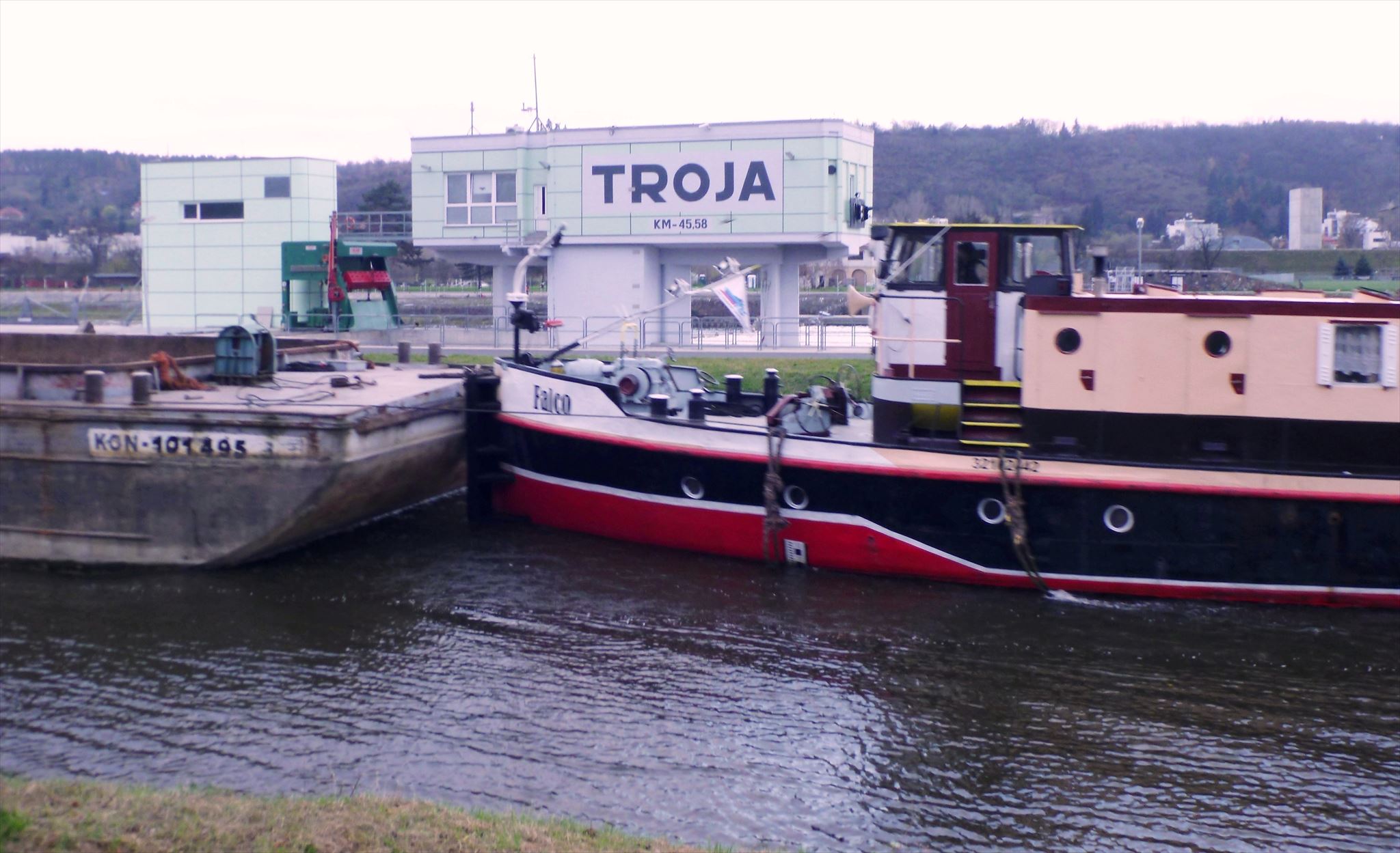
TROJA
Malá vodní elektrárna Troja se nachází na levém břehu Vltavy na špičce Císařského ostrova.
TROJA
The small Troja hydroelectric power plant is located on the left bank of the Vltava at the tip of the Imperial Island.
V pražské Troji stojí nová vodní elektrárna
There is a new hydroelectric power plant in Prague's Troja
V pražské Troji byla dokončena stavba malé vodní elektrárny. Výkon elektrárny je jeden megawatt a celá stavba stála 347 miliónů korun. Investice by se měla vrátit do osmi let.
Stavební část vodního díla stála celkem 206 miliónů korun a realizovala ji společnost Metrostav. Technologickou část v hodnotě 141 miliónů korun dodala firma Siemens Engineering.
Investor stavby Povodí Vltavy předpokládá, že zdroj energie ročně vyrobí 12,9 gigawatthodin elektřiny, což odpovídá roční spotřebě asi 5000 domácností.
The construction of a small hydroelectric power plant was completed in Prague's Troja. The power plant's output is one megawatt and the entire construction cost 347 million crowns. The investment should return within eight years.
The construction part of the waterworks cost a total of 206 million crowns and was implemented by Metrostav. The technological part worth 141 million crowns was supplied by Siemens Engineering.
The Vltava River Basin investor assumes that the energy source will produce 12.9 gigawatt-hours of electricity per year, which corresponds to the annual consumption of about 5,000 households.
Na území Prahy vyrábějí elektřinu ještě tři elektrárny – Štvanice, Podbaba a Modřany.
There are three other power plants in Prague - Štvanice, Podbaba and Modřany.
Stage č.2
N 50°06.641
E 014°25.644
Souřadnice vás dovedou před toto vodní dílo a vašim úkolem bude najít schody do vody, na kterých je vodočet. Jeho horní číslo je C. Na tom samém místě jsou mezi pěšinou na břehu a silnicí dvoje schody. Spočítejte na nich počet schodů a po ciferaci máte D.
Stage # 2
N 50 ° 06.641
E 014 ° 25.644
The coordinates will take you to this waterworks, and your task will be to find the stairs to the water that have a water meter. Its upper number is C . In the same place, there are two steps between the path on the shore and the road. Calculate the number of steps on them and after the numbering you have D.
ŠTVANICE
Vodní elektrárna Štvanice
Na začátku 20 století v letech 1903 až 1914 byla vybudována na špici ostrova Štvanice vodní elektrárna o výkonu 1,42 MW. Ve stejné době byla nedaleko budována ještě druhá vodní elektrárna a to nedaleko dnes již neexistujícího nádraží Těšnov, jehož krásná budova musela být odstřelena kvůli stavbě severojižní magistrály. Vodní elektrárna Těšnov, do které voda byla přiváděna potrubím, byla zrušena v roce 1929, kdy bylo celé rameno Rohanského kanálu, kam ústil odtok, zasypáno. Elektrárna na Štvanici byla poslední vodní elektrárnou na Vltavě a to až do roku 1973. Tehdy byla elektrárna pro celkové opotřebení odstavena a vtoky byly zabetonovány.
Při konstrukci elektrárny bylo využito čtyřmetrové převýšení Helmovského jezu a v elektrárně pracovaly 3 Francisovy turbíny resp. se jednalo o třístupňovou Francisovu turbínu vyrobenou u firmy Kolben & Daněk. Jedna z turbín je dodnes vystavena v exteriéru areálu elektrány. V letech 1984 až 1987 byla elektrárna rekonstruována a v roce 1988 byl ukončen zkušební provoz a elektrárna byla nově uvedena do provozu. Namísto původních Francisových turbín zde byly nově instalovány tři Kaplanovy turbíny o celkovém výkonu 5,7 MW. Pražské pouliční osvětlení potřebuje přibližně právě tolik. Technologie elektrárny je ovládána na dálku z centrály ve Štěchovicích.
Budova elektrárny je secesní novoklasicistní s kupolovitou věží a byla navržena architektem Aloisem Dlabačem a postavená firmou Kapsa & Müller. Jde o jednoduchou stavbu, která využívá renesančních motivů francouzské zámecké architektury. Budova má čtyřhrannou pětiposchoďovou věž o půdorysu 7,5 x 7,5m a výšku 22m. Věž je zakončena kruhovým posledním poschodím altánového provedení a kruhovou kupolí se špicí vysokou 8m. Základy budovy byly původně postaveny na dřevěných pilotách ve štěrkopísku. Při rekonstrukci v 80. letech musely být tyto základy postupně vybourány až na skalní podklad a byly navíc zajištěny betonovou injektáží a pomocí mikropilot. Další oprava musela následovat po povodních v roce 2002, kdy byl ostrov devastován. Smutnou památkou této devastace je nedávné zbourání Zimního stadiónu Štvanice, který stál jen o pár metrů dále. Tento osud naštěstí elektrárnu nepostihnul a tak je dnes na začátku ostrova solitérní budovou.
ŠTVANICE
Štvanice Hydroelectric Power Plant
At the beginning of the 20th century, between 1903 and 1914, a 1.42 MW hydroelectric power plant was built at the top of the Štvanice island. At the same time, a second hydroelectric power plant was built nearby, not far from the now non-existent Těšnov railway station, whose beautiful building had to be blown up due to the construction of the north-south highway. The Těšnov hydroelectric power plant, to which water was supplied by pipeline, was closed down in 1929, when the entire arm of the Rohan Canal, where the outflow led to it, was backfilled. The Štvanice power plant was the last hydroelectric power plant on the Vltava until 1973. At that time, the power plant was shut down for general wear and the inlets were concreted.
During the construction of the power plant, a four-meter elevation of the Helmov weir was used, and 3 Francis turbines resp. it was a three-stage Francis turbine manufactured at Kolben & Daněk. One of the turbines is still on display in the exterior of the power plant complex. Between 1984 and 1987, the power plant was reconstructed and in 1988 the trial operation was terminated and the power plant was newly put into operation. Instead of the original Francis turbines, three Kaplan turbines with a total output of 5.7 MW were newly installed here. Prague's street lighting needs just as much. The power plant technology is controlled remotely from the headquarters in Štěchovice.
The power plant building is an Art Nouveau neoclassical building with a domed tower and was designed by architect Alois Dlabač and built by Kapsa & Müller. It is a simple building that uses Renaissance motifs of French castle architecture. The building has a square five-storey tower with a floor plan of 7.5 x 7.5 m and a height of 22 m. The tower ends with a circular last floor of a gazebo design and a circular dome with a peak 8 m high. The foundations of the building were originally built on wooden piles in gravel. During the reconstruction in the 1980s, these foundations had to be gradually demolished to the ground and were also secured by concrete grouting and micropiles. Another repair had to follow the floods in 2002, when the island was devastated. A sad reminder of this devastation is the recent demolition of the Štvanice Winter Stadium, which stood just a few meters away. Fortunately, this fate did not affect the power plant, so today it is a solitary building at the beginning of the island.
Noční osvětlení je zvlášt působivé a efektní.
Night lighting is especially impressive and effective.
Stage č.3
N 50°05.620
E 014°25.943
Souřadnice vás přivedli na pravý břeh před toto krásné architektonické dílo. Asi 60 metrů jižním směrem do vnitrozemí je park Lannová. Spočítejte nerezové cvičební přístroje na různé pohybové aktivity a máte E.
Stage # 3
N 50 ° 05.620
E 014 ° 25.943
The coordinates brought you to the right bank in front of this beautiful architectural work. About 60 meters south inland is the park Lannová. Count the blue-red devices for different physical activities and you have E.
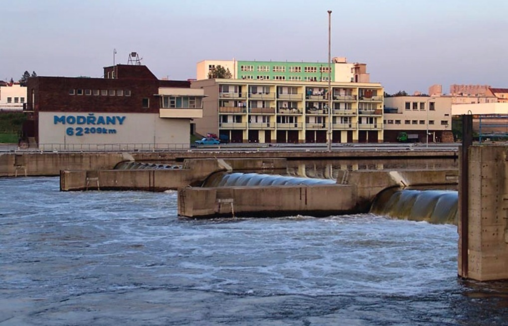
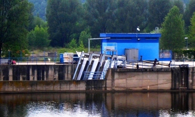
MODŘANY
Malá vodní elektrárna Modřany se nachází poblíž soutoku Vltavy a Berounky, dále po proudu až na úrovni dostihového závodiště ve Velké Chuchli. Sídlí na říčním kilometru 62,209 mezi pražskými městskými částmi Modřany a Velká Chuchle.
Úvodní projekt “Zdymadlo Modřany” byl naplánován a schválen v roce 1977 za účelem zlepšení podmínek pro osobní lodní dopravu z Prahy do Slap a vodní nákladní dopravu do budoucího přístavu v Radotíně. Problémem totiž bylo mělké dno Komořanské a Modřanské úžiny. Postavením Modřanského jezu se hladina Vltavy zvýšila o 1,4 metru a výstavba přístavu na Berounce v Radotíně ji zvedla o další metr.
Stavba jezu a zdymadla byla zahájena v dubnu 1979 na řece Vltavě naproti tehdejšímu národnímu podniku Elektropřístroj. Stavba měla několik částí: plavební komoru, jezové pole, malou vodní elektrárnu a propust pro sportovní lodě.
Stavbu prováděl podnik Vodní stavby Praha a beton mu dodávala Centrální betonárna Modřany.
V druhé polovině července 1982 došlo k neočekávané povodni, při které byla provalena stěna plavební komory. Z toho důvodu byly na 4 měsíce přerušeny veškeré práce na první etapě.
V roce 1983 byla dokončena stavba plavební komory včetně manipulačního domku, budovy s bytovými jednotkami pro zaměstnance a úpravy plavební dráhy pravého břehu.
Koncem roku 1983 bylo rozhodnuto, že se v malé vodní elektrárně na levém břehu použijí tři Kaplanovy turbíny kolenového typu 4-KPK-10. Stavba na elektrárně byla zahájena v roce 1984 a rok na to byla dokončena hrubá betonová stavba a propust pro malá sportovní plavidla.
Roku 1984 byla dokončena technologická část prací na pravém břehu a všech tří jezových polí včetně manipulačního domku zdymadla (velínu), který slouží pro ovládání jezu a plavební komory. Součástí objektu s bytovými jednotkami na pravém břehu je i transformátorová stanice.
V červnu 1984 bylo celé vodní dílo předáno podniku Povodí Vltavy – závod Dolní Vltava.
V roce 1986 proběhla instalace technologických součástí pro malou vodní elektrárnu.
MODŘANY
The small Modřany hydroelectric power plant is located near the confluence of the Vltava and Berounka rivers, further downstream to the level of the racecourse in Velká Chuchle. It is located at the river kilometer 62,209 between the Prague districts of Modřany and Velká Chuchle.
The introductory project “Modřany Lock” was planned and approved in 1977 in order to improve the conditions for passenger shipping from Prague to Slapy and water freight transport to the future port of Radotín. The problem was the shallow bottom of the Komořany and Modřany straits. With the construction of the Modřanský weir, the level of the Vltava rose by 1.4 meters and the construction of the port on Berounka in Radotín raised it by another meter.
Construction of the weir and lock began in April 1979 on the Vltava River opposite the then national company Elektropřístroj. The building had several parts: A lock chamber, a weir field, a small hydroelectric plant, and a culvert for sports boats.
The construction was carried out by the company Vodní stavby Praha and the concrete was supplied to it by the Central Concrete Plant Modřany.
In the second half of July 1982, an unexpected flood occurred, during which the wall of the lock chamber collapsed. As a result, all work on the first stage was suspended for 4 months.
In 1983, the construction of the lock was completed, including a handling house, a building with staff housing, and alterations to the right bank fairway.
At the end of 1983, it was decided to use three Kaplan 4-KPK-10 elbow turbines in a small hydroelectric power plant on the left bank. Construction at the power plant began in 1984, and a year later the rough concrete construction and culvert for small sports vessels were completed.
In 1984, the technological part of the work on the right bank and all three weir fields was completed, including the lock house (control room), which is used to control the weir and lock chamber. A transformer station is part of the building with housing units on the right bank.
In June 1984, the entire waterworks was handed over to the Vltava River Basin - Dolní Vltava Plant.
In 1986, technological components for a small hydropower plant were installed.
Celá stavba vodního díla Modřany byla ukončena v roce 1987.
The entire construction of the Modřany waterworks was completed in 1987.
Malá vodní elektrárna v Modřanech.
Small hydroelectric power plant in Modřany.
Stage č.4
N 50°00.407
E 014°23.912
Nyní vás souřadnice dovedli poblíž betonového kruhového podstavce, kam vede betonová lávka se silným betonovým zábradlím. Když se dostanete na ten kruhový podstavec, stanou se z vás, aspoň na chvíli, živé sochy. Zde opravdu měli stát 3 sochy, ale jak už to tak bývá, z důvodů nedostatku financí, stavba soch už realizována nebyla.
Čekají na vás poslední dva úkoly.
Ve spodní části zábradlí jsou obdélníkové otvory. Spočítejte je všechny. Ciferací budete mít číslo F.
Na kruhovém betonovém podstavci spočítejte, kolik je kruhových betonových základen ? Částečné výseče, které tvoří schod nepočítejte a máte G.
Stage # 4
N 50 ° 00.407
E 014 ° 23.912
Now the coordinates have taken you near a concrete circular pedestal, where a concrete footbridge with a thick concrete railing leads. When you get to that round pedestal, you will become, at least for a while, living statues. There really were supposed to be 3 statues here, but as usual, due to lack of funds, the construction of the statues was no longer realized.
The last two tasks are waiting for you.
There are rectangular holes at the bottom of the railing. Count them all. You will have the number F.</$
with the number
On a round concrete pedestal, calculate how many round concrete bases there are? Do not count the partial sections that make up the step and you have G.
A teď už pro finálku ,která je na souřadnicích :
N 50°(A-5)(A-5).(B+2)(C-6)C
E 014°(G-2)(G-1).(F+3)(E-6)(D-2)
Nic nezvedejte ani nepřemisťujte! Pro kešku stačí jen šáhnout.
And now for the final, which is in coordinates:
N 50 ° (A-5) (A-5). (B + 2) (C-6) C
E 014 ° (G-2) (G-1). (F + 3) (E-6) (D-2)
Do not lift or move anything! Just reach for the cache.
Za betatest děkuji buabu a modřínkovi.
S překladem do angličtiny pomohl strejda Google
Uncle Google helped translate into English.