This cache has been placed with the kind permission of the landowners, The National Trust.
This earthcache is about the formation of the striking Mendip Hills and the rocks that they are made from. To learn more about the later formation of the gorge itself, you may also like to visit the Cheddar Gorge Earthcache.
The Mendips Hills run between Weston-super-Mare and Frome in Somerset. They are made up of sedimentary rocks ranging in age from Late Devonian (approximately 359 million years old) to Mid Jurassic (about 161 million years ago). The area is dominated by carboniferous limestone, clear examples of which can be seen here at Cheddar.
At the beginning of the Carboniferous period the previously aridMendip area became part of a vast shallow tropical sea that stretched from Belgium to Pembrokeshire. The initial flooding produced mud-rich limestone followed by a succession of coral-rich limestones. These coral rich limestones are the ones that dominate the landscape here at Cheddar and the rest of the Mendips. In geological ascending order they are: Black Rock Limestone, Burrington Oolite, Clifton Down
Limestone and Oxwich Head Limestone.
Each of these limestones has it's own characteristics. Below are descriptions and pictures of each of which will better help you to identify the rocks you see here in
Mendip:
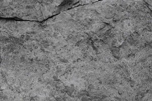
Black Rock Limestone is dark grey or black, varying between 250 m thick in the western Mendips to 370m in the east. Parts of the Black Rock Limestone have
been altered to dolomite through a process known as dolomitisation. Dolomitisation is when some of the calcium in the limestone is replaced by magnesium. Crinoids, corals and brachiopod fossils are common.
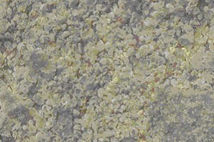
Burrington Oolite is typically 210 m thick over Mendip. The limestone is predominantly comprised of ooliths which are small rounded grains with a concentric cross-section. The limestone is typically pale grey in colour.
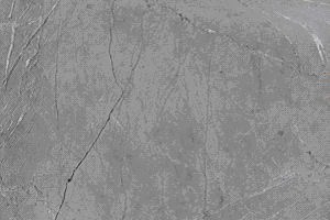
Clifton Down Limestone is a fine grained grey-black limestone that also contains nodules and bands of chert. It also contains the fossil remains of the coral lithostrotion martini. This limestone forms the majority of the rock visible in Cheddar.
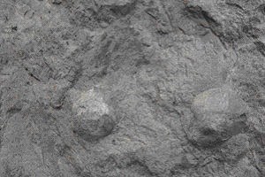
Oxwich Head Limestone is a grey crinoidal and oolitic limestone containing abundant fossilised corals and thick-shelled brachiopods. The thickness varies from 125 m to about 230 m, with a general increase in a north-easterly direction across the Mendip area.
At the end of the Carboniferous period continental drift caused the ocean lying across the south of Britain to close. The landscape was then pushed up into a vast
mountain range that stretched for thousands of kilometres to the east and west. This period of mountain building, is know as the Variscan Orogeny. The Variscan Orogeny occurred when two land masses called Euramerica and Gondwana collided to form the super continent Pangaea. This collision caused ripples in the surface of the earth and amongst others, was responsible for the formation of the Mendip Hills that are visible today, forcing the former limestone seabeds into a whale back shape. The Mendips are close to the northern limit of the mountains created during the Variscan Orogeny and would probably reached an original altitude of roughly
1500m. Subsequent weathering has reduced the size of the hills considerably since their initial formation.
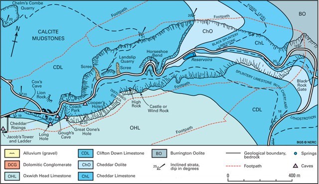
The Mendip range consists of four folds which are located at Blackdown, North Hill, Pen Hill and Beacon Hill. The Mendips are anticlinal, meaning that the oldest rocks are at the core. Erosion now means that the older rock layers are now visible at the surface. This, and the fact that the rock here dips at approx 20 degrees South West, means that each of the successive layers of stratigraphy are visible as you walk along the Gorge. The diagram below shows you the locations of each of these stratigraphic layers and where you can go to see them at Cheddar:
To Claim This Earthcache:
The coordinates for this cache bring you to Black Rock Quarry at the top of the Cheddar gorge. Here you can see a good example of one of
the limestones that make up the Mendip Hills.
1) Please examine this rock and identify what type of limestone it is. Email this answer to my profile.
2) In addition and as proof you have been to the quarry, please estimate the size of the height of the quarry cliff directly in front of you. These rocks can be dangerous, and it is not necessary for you to climb on them to get your answers - please take care.
Feel free to log this earthcache without waiting for a reply from me. If there is a problem with your log or answers I will contact you via your profile to clarify. Please don't include your answers in your log.
Thank you for visiting :)