The many meres and mosses scattered across the Cheshire Plain make this one of England’s most important wetland areas. More than sixty lakes and peatland sites contribute to Cheshire’s watery character. In fact, the county can boast the highest density of ponds anywhere in Europe.
Five sizeable meres lie within the parish of Marbury, the largest of which is Big Mere. The Cheshire meres were created at the end of the last Ice Age, around 15,000-12,000 years ago. At first the area was submerged beneath a vast ice sheet up to a kilometre deep. But as the climate warmed, the ice sheet gradually ‘retreated’ northwards, leaving behind immense chunks of ice embedded in the glacial debris dropped by the ice sheet.
When these huge icebergs melted, they left behind basin-shaped hollows, called ‘kettle holes’, that later filled with water. Most are shallow, but a few have been deepened by subsidence where groundwater has dissolved the underlying salt beds.
Kettle holes often occur in association with kames in what is known as kettle and kame topography. Kames are amongst the most varied landforms resulting from deposition by glacial meltwater. A kame may occur as an isolated hill but more generally each kame is one mound in a low-lying terrain of many hummocks, terraces, ridges and hollows.
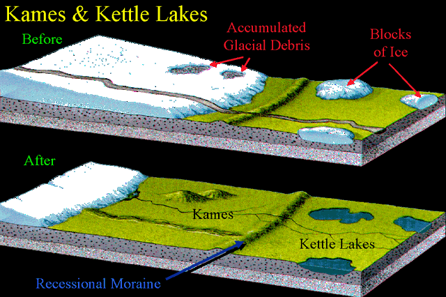
There are two types of kettle holes which develop following the glacial deposition - kettle lakes and kettle bogs. Kettle lakes, typically less than 2km in length and less than 10m deep, are fed by rivers and streams either below or above ground. Kettle bogs, which have no water source other than precipitation, appear brown or muddy and contain large amounts of decomposing organic plant matter.
Your tasks:
To log this cache, you will need to complete the tasks below. The co-ordinates take you to the edge of Big Mere where you will have to make some observations and explain what you see. Please message us with the info (rather than post it on your log). You can log a find as soon as you send us a message, but we may delete your log if your answer is way off the mark.
- Walk along the footpath to Big Mere and observe the area. Explain what you see (eg reed beds, dense growth, boggy areas, expanses of water, estimate of depth of water etc). Using your observations and the information given above, say how you think this kettle formed and what type of kettle it is.
- Look at the wider landscape around the mere and explain what you see. Is it flat, undulating, hilly, craggy, rocky etc. Can you explain what formed this landscape?
- As an optional extra, post a picture on your log of yourself and / or your GPSr next to Big Mere.
THIS CACHE HAS BEEN PLACED TO COMMEMORATE 10 YEARS OF EARTHCACHES.


For information about the series click the picture above.