Deutsch
Und sie mahlen bis in alle Ewigkeit!
«Wie an einer Perlenschnur aufgereiht präsentieren sich die Gletschertöpfe dem Wanderer, gefüllt mit kristallklarem Wasser» (Bündner Tagblatt, Simon Schick, 22.10.11)
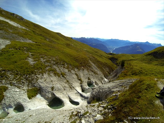
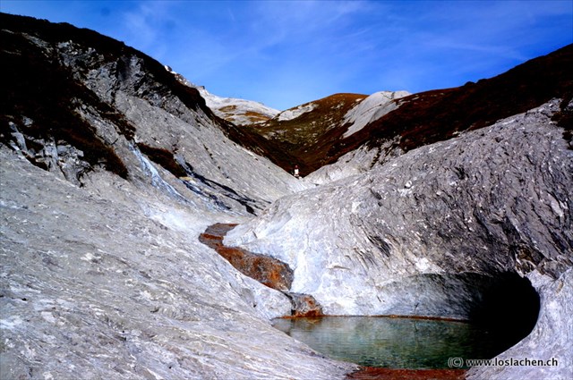
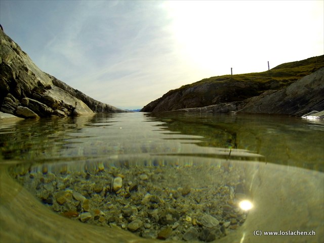
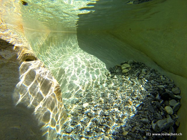
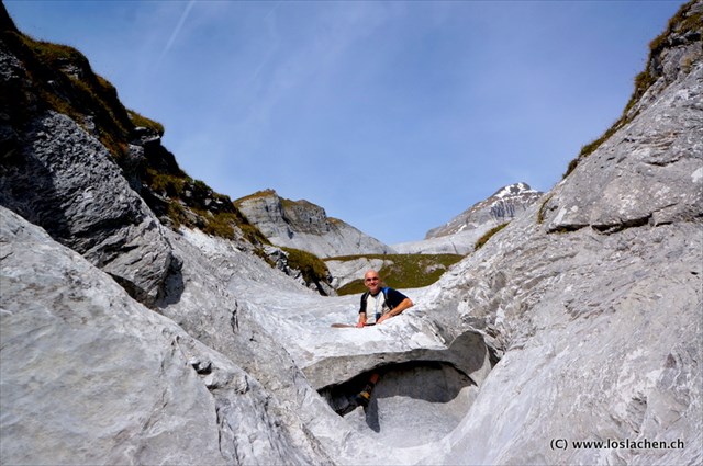
Der Maliensbach, welcher auf der Trinser Alp Mora (1'900 m.ü.M.) entspringt, dreht seit hunderten von Jahren grosse Steine, Sand und Kies immer am gleichen Ort um die eigene Achse. So haben sich in Jahrhunderte währender Arbeit natürliche, Käsekessel grosse Badewannen (Gletschermühlen) gebildet. Jede «Gletschermühle» ist in seiner Form, seinem Aussehen und seiner Tiefe einzigartig. Die einen sind klein und fast kreisrund, die anderen hingegen ellipsenförmig und genügend gross um darin zu baden. Die grösste und schönste Ansammlung an «Gletschermühlen» findet sich auf Höhe der Mutta Sura, wo die knapp 20 Gletschertöpfe auch gut zugänglich sind.
Während den Sommermonaten wärmt sich das kristallklare Wasser in diesen Wannen auf und lädt Gross und Klein zu einem herrlichen Naturbad ein. Die «Gletschermühlen» sind immer mit Wasser gefüllt, auch dann wenn der Maliensbach kein Wasser führt!
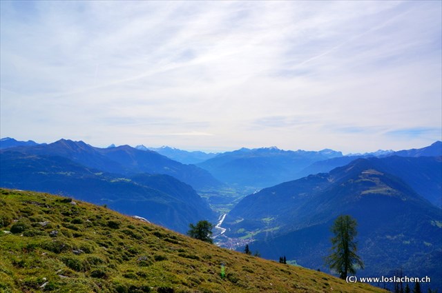
Für die rund 1‘200 Höhenmeter (Aufstieg von Trin auf die Alp Mora und zurück) sollte man rund fünf Stunden einplanen. Der anstrengende Aufstieg auf dem ehemaligen Alpweg von Trin oder via Bargis und die Alp Lavadignas auf die Alp Mora zahlt sich aber nicht nur durch das einmalige Badeerlebnis, sondern auch durch die wunderbare Aussicht und faszinierende Rundblick auf den Piz Beverin und das Safiental aus.
Wussten Sie dass...
Der Geologieprofessor der Universität Bern, Adrian Pfiffner, erklärt, dass ein Gletscher die Entstehung einer «Gletschermühle» zwar begünstigt für dessen Entstehung aber keinesfalls zwingend vorhanden sein muss. Ein weiteres Märchen um die Strudeltöpfe ist, dass sich in ihrer Mitte ein Stein oder Sand befinden muss. Solches Geschiebe kann gemäss Pfiffner zwar den Fels schön glatt polieren, ist aber nicht zwingend notwendig um den eigentlichen Topf zu erodieren. Grundvoraussetzung für die Entstehung einer «Gletschermühle» ist Wasser. Das Wasser muss eine starke Strömung haben so dass sich ein Strudel bildet (Bündner Tagblatt, Simon Schick, 22.10.11).
Quelle: (vgl.) trin-verkehrsverein.ch
Der Weg zu den Mühlen
Trin - Gletschermühlen - Trin
Höhendifferenz: 1'100 Meter
Schwierigkeit: Schwere, lange Wanderung
Dauer: 3.5/4h
Jahreszeit: Frühling bis Herbst
Die Wanderung beginnt bei der Postautostation Trin-Quadris, mitten im Dorf. Von hier geht’s auf dem alten Alpweg bergwärts bis hoch auf die Alp Mora (ca. 1'900 m.ü.M). Der Weg führt Sie durch den lichten Wald, welcher angenehmen Schatten spendet und immer wieder den Blick ins Safiental und en Piz Beverin freigibt. Nach ca. 2.5 Stunden erreicht man die Alp Mora. Der Aufstieg von Trin zur Alp Mora ist lang und im zweiten Teil recht steil. Dafür kommst man relativ schnell über die Baumgrenze in eine fantastische Bergwelt und den Lebensraum von Murmeltieren, Steinadlern, Gämsen und Steinböcken.
Bei der Alphütte Alp Mora angekommen gehen Sie Richtung Osten zu der Platt Alva (auf Deutsch: weisse Platte). Der Weg verliert sich langsam und wird zur Spur, der aber problemlos zu folgen ist. Auf gleicher Höhe mit den Lawinenverbauungen überqueren Sie so die Alpweiden bis Sie nach ca. 30 Minuten auf die Val Malines stossen (Maliens Bach) und erreichen so die berühmten Gletschermühlen.
Für den Abstieg gehen Sie nach Osten Richtung Tamins. An der Kante vom Lavoitobel entlang geht es steil hinunter bis Sie schliesslich die Strasse Richtung Maliens kreuzen. Folgen Sie dem Weg über Fastatg nach Trin.
Logerlaubnis erlangen:
Bitte sendet uns die Antworten per Mail über unser Profil.
Wartet nicht auf die Logfreigabe (wir melden uns, wenn etwas nicht stimmen sollte)
Würden uns sehr freuen, ein-zwei Fotos im Log zu sehen, dieses ist aber keine Logbedingung
Um diesen Earthcache loggen zu dürfen musst du die folgenden Fragen beantworten.
- Gehe zu den angegebenen Koordinaten. Was für eine Form hat die Mühle, bei welcher du nun stehst (direkt unter dem Ablauf steckt ein Eisen).
- Schätze wie viel Wasser diese Mühle fassen kann. (Angabe in Liter oder m3).
- Was wurde hier, (ausser dem Eisen) von Menschenhand gefertigt?
- Was ist laut A. Pfiffner als einziges zwingend nötig für die Entstehung einer Gletschermühle?
- Warum ist in den Gletschermühlen immer Wasser, auch wenn der Maliensbach kein Wasser führt.
- Freiwillig: Gehe zu den Koordinaten N46°51.352 E009°21.955 und mache dort ein lustiges Bild von der speziellen Mühle mit der Brücke und dir oder deinem GPS
Jetzt wünschen wir viel Erfolg
Englisch
And they keep grinding for ever and ever!
«These glacial pools, filled with crystal-clear water, present themselves to the hiker like a string of pearls» (translated from Bündner Tagblatt, Simon Schick, 22.10.11)
The Maliens Brook, whose source is at 1,900 m above sea level on Alp Mora above Trin, has kept churning rocks, sand and pebbles for hundreds of years in the same places. Thus, after many centuries nature created these pools (“Gletschermühlen” or glacial mills), big as cauldrons. Each one of them is unique in shape, appearance and depth. Some are rather small and almost perfectly round, others more elliptical and big enough to take a bath in. The largest and most awesome group of “Gletschermühlen” can be found near Mutta Sura, where the almost 20 pools are easily accessible.
During summer the sun heats up the pristine water in the tubs and invites big and small to take a plunge into these phenomenal natural dip-pools. The “Gletschermühlen” are always filled with water, even when the Maliens Brook itself runs dry!
You should plan about 5 hours for the hike from the village of Trin to Alp Mora and back (approximately 1,200 meters difference in altitude). The ascent from either Trin, via a former “Alpweg” (trail), or from Flims/Bargis to Alp Lavadignas and then on to Alp Mora, is rather strenuous. But you will be rewarded not only by a dip in a unique natural pool but also by the phenomenal and fascinating vistas of Piz Beverin and the Safien Valley.
Did you know ...?
Adrian Pfiffner, professor of geology at the University of Berne, explains that glaciers enhance the formation of “Gletschermühlen” but that they are no necessary condition for their existence. A further myth surrounding these natural whirlpools calls for stones and sand in their center. While this material could serve to grind the walls of the pools to a shiny polish it is by no means necessary to erode the actual shape of the basin. The only basic requirement for the development of a “Gletschermühle” is water – with a strong enough current to form a vortex (translated from Bündner Tagblatt, Simon Schick, 22.10.11).
Source: see www.trin-verkehrsverein.ch
How to get to the Glacial pools
Trin - Gletschermühlen - Trin
Vertical ascent: 1,100 meters
Difficulty: Long, exhausting hike
Duration: 3.5/4h
Season: Spring to fall
The hike starts at the bus station (Postautostation) Trin-Quadris, right in the center of the village of Trin. Follow the marked old trail (“Alpweg”) up to Alp Mora (at about 1,900 m above sea level). The trail leads through a light forest which provides a most welcome shade and affords ample opportunities to see the Safien Valley and Piz Beverin. After about 2 ½ hours you will reach Alp Mora. The hike up from Trin is long and the second half is rather steep. On the other hand, you quickly gain altitude and reach the glorious alpine region above the tree line where marmots, eagles, mountain deer and the ibex live.
Once at Alp Mora turn eastward to Platt Alva (Weisse Platte or White Plateau). After a while the trail will become just a track, but not too difficult to follow. You should now be crossing the alpine meadows at the altitude of the avalanche barriers. After approximately half an hour you will hit Val Malines (Maliens Brook) and you will have finally reached the famous Gletschermühlen.
Your descent will lead you eastward to Tamins. Follow a steep path along the edge of the Lavoitobel (Tobel = ravine) until you finally reach the forest road to Maliens. Follow the road to Fastatg and on to Trin.
How to log this cache:
Please, send your answers to us by email (see our GC profile).
You do NOT have to wait for a clearance to log (if there should be any problem, we will let you know).
We would be happy if you would upload one or more pictures with your log – but, of course, this is no condition to be able to log
To log this Earth Cache you need to answer the following questions:
- At the listed coordinates: which form does this particular pool have? (directly beneath the pool there is a little piece of metal sticking out of the rock)
- Estimate how much water this particular pool holds (in liters or m3)
- There is something else nearby made by humans: what is it?
- According to A. Pfiffner, what is the only necessary condition for the formation of a “Gletschermühle”?
- Why is there always water in the pools, even if the Maliens Brook runs dry?
- Not required: Continue to the coordinates N46°51.352 E009°21.955 and take a picture of this peculiar pool with the bridge and yourself and/or your GPS
And now … good luck!!
Herzlichen Glückwunsch
Gold: pinkpetra
Silber: tinflaida
Bronze: mountain-fantasy
Leder: bigGBS