This EarthCache is not available during the winter. The Monument and Preserve remains open all year, although winter snows prevent automobile access around the Loop Road from mid-November through mid-April. Please consult the Craters of the Moon National Monument website for updates on road closures.
The posted coordinates are for the parking area and trail head for the Caves Trail. The paved trail is 0.8 miles (1.3 km) one way. It is wheelchair accessible and all questions can be answered from the trail. I have rated the terrain as a 2 due to the distance involved.
There are four stops along this trail where you will need to answer questions. The coordinates for these stops are listed in the Logging Requirements area and have been added as Additional Waypoints. Please remember that rock collecting is prohibited in National Park areas.
Craters of the Moon National Monument
Craters of the Moon National Monument was established in 1924 and expanded greatly in November 2000. It now covers about 1,100 square miles (~2,800 square kilometers). Craters of the Moon formed during eight major eruptive periods between 15,000 and 2,000 years ago with a recurrence interval averaging 2,000 years. Instead of erupting from one enormous volcano, lava oozed up from a series of deep cracks that start near the visitor center and stretch 52 miles (84 kilometers) to the southeast. It has been over 2,000 years since the last eruption.
Lava Tubes
Lava rivers become lava tubes when the exterior of a flow cools allowing hot, fluid lava to continue to flow beneath the surface. Within these insulated underground passages the molten lava can continue to flow for many miles, until the source of the lava gets cut off leaving behind a "cave".
Types of Lava
Lavas, particularly basaltic ones, come in two primary types: pahoehoe (pronounced 'paw-hoey-hoey") and ʻaʻā (pronounced "ah-ah"). Both names, like a number of volcanological terms, are of Hawaiian origin.
The pahoehoe flow has a comparatively smooth or "ropy" surface. The surface of the ʻaʻā flow consists of free chunks of very angular pieces of lava. A good way to remember which is which is to think of the sound you would make trying to walk barefoot over the rough and angular ʻaʻā lava.
ʻAʻā forms when lava flows rapidly. Under these circumstances, there is rapid heat loss and a resulting increase in viscosity. When the solid surface crust is torn by differential flow, the underlying lava is unable to move sufficiently rapidly to heal the tear. Bits of the crust are then tumbled in and coated by still liquid lava, forming the chunks.
Pahoehoe forms when lava flows more slowly. Under these circumstances, a well-developed skin can form which inhibits heat loss. When a tear in the skin does form, it is readily healed.
These photos of the different types of lava were taken by junglehair in Hawaii in 2012.
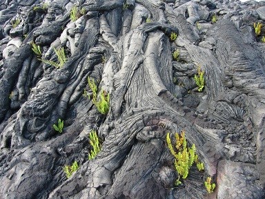
Pahoehoe
|
ʻAʻā
|
Logging Requirements
To log this EarthCache please send an email through the link in my profile with the answers to the following questions:
Stop 1: N 43° 26.687 W 113° 31.864
According to the sign, how many miles did the Blue Dragon lava flow from its source at the Spatter Cones approximately 2000 years ago?
Look at the rocks around the sign. Would you say this is an example of pahoehoe or ʻaʻā lava?
Based on what you have read about how lava tubes form, and the properties of this type of lava, how do you think that assisted in the formation of the lava tubes here?
Stop 2: N 43° 26.653 W 113° 31.715
Does the roof of the dewdrop cave appear to be smooth? Why do you think that is or isn't the case?
Stop 3: N 43° 26.597 W 113° 31.716
Do you think the lava tube on the East or West side of the trail collapsed first? Explain your answer.
Stop 4: N 43° 26.550 W 113° 31.794
Do the walls and ceiling in this lava tube appear to be rough or smooth? No need to go inside, just base your answer on what you can see from the trail.
Photos are welcome, but not required.
Once you have emailed your answers, feel free to log your find immediately - you do not need to wait for a response. Don't worry if you don't know the exact answers. These questions were designed to get you thinking about the processes that shaped this area. Do your best and tell us the reasons why you answered the way you did. We will respond to your email to confirm if your answers were correct.
References:
Owen, Douglass and Melander, Sonya. Geology of Craters of the Moon. National Park Service. 2013. http://www.nps.gov/crmo/naturescience/loader.cfm?csModule=security/getfile&pageid=648202
http://www.geo.cornell.edu/geology/GalapagosWWW/LavaTypes.html
Signage at Craters of the Moon National Monument
EarthCache Supporter