This is an Eartchcache, there is no physical container.
Please stay on the trails and obey all park rules.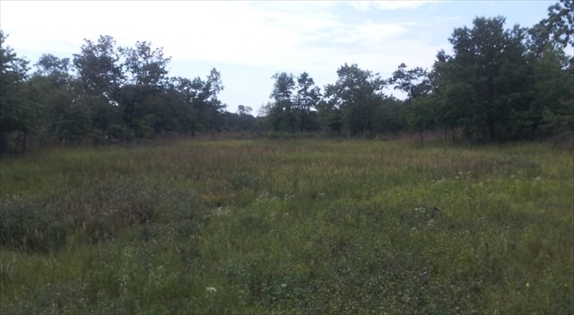
What is a panne:
A panne is an ecosystem found near freshwater and saltwater coastal areas. It is a narrow wetland formed in a depression between two elevated features. The North Dune Panne near Lake Michigan was formed in a low area, called a swale, between two sand dunes. The water levels in pannes are ever changing. Most pannes are saltwater systems, but freshwater pannes do occur and are considered globally rare and significant ecosystems. In the United States freshwater pannes are found only on the southern tip of Lake Michigan.
How was this panne formed:
This panne was formed as part of natural littoral sand drift processes on Lake Michigan. The littoral zone is the part of the lake that is close to the shore. In coastal environments the littoral zone extends from the high water mark, which is rarely underwater, to the shoreline areas that are always underwater.
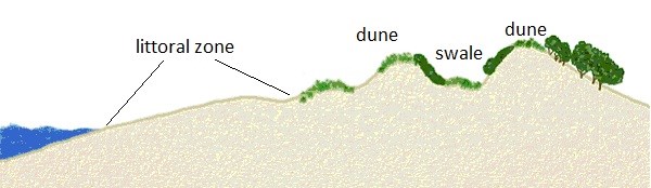
The North Dune Panne is in an area that was formerly a beach. Wind blew the lakeshore sand to form sand dunes. The former beach became isolated between a new dune and an old dune and a swale was formed. This long, narrow strip of land is protected from the harshest conditions of the lakeshore. Over time organic material and nutrients collected creating a sandy soil where plants could grow.
The earth science of a panne:
The feature that makes a panne unique is its hydrology. While most wetland systems are dependent on surface water flow or groundwater infiltration, pannes are dependent on the water level of the resident sea, ocean or lake. The water table of the resident water source helps keep the soil hydrated. Pannes are often isolated from creeks and streams so rain and run-off is trapped within the panne. Because of the panne's proximity to the resident water source the water table is very close to the surface of the swale and that slows the infiltration of water through the soil. As a result the soil remains moist despite its high permeability. In years where the water level of Lake Michigan is high the North Dunes Panne can contain surface water into mid-summer and the sandy soil can remain saturated throughout the growing season.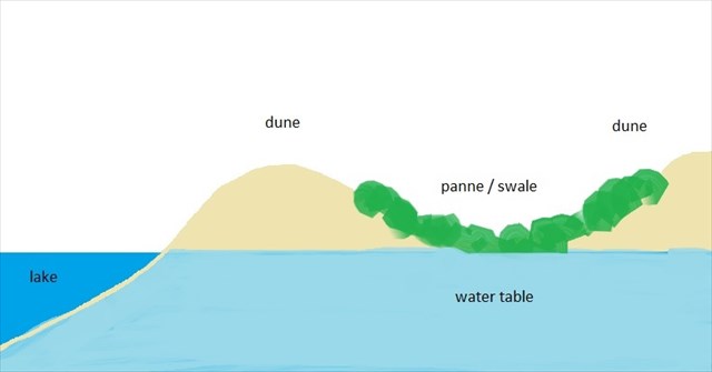
The ecology of pannes:
The unique hydrology of this panne allows a wide variety of plant species to grow in the area. Wetland and wet-prairie species are most common. This intermingling of plants from normally distinct ecosystems results in high biodiversity relative to other wetland ecosystems. Vegetation colonizes via seed banks present in the recently deposited sand and through wind and animal transport from adjoining habitats.
In order to log this cache please do the following:
1) Optional -- post a picture of yourself and your gps'r at the posted coordinates;
2) Record the following in your notes (but do not post in your log):
a) using you gps'r estimate the elevation of the swale (ground level) at the posted coordinates;
b) using your gps'r estimate the elevation at N42 25.246, W87 48.376, this is the ridge of the new dune;
c) using your gps'r estimate the elevation at N42 25.236, W87 48.187, ground level at the lake's edge;
3) Email me the answer to the following 2 questions:
a) Based on your elevation estimations and observations at the sites, by how many feet would the lake level have to rise to reach the top of the dune?
b) Based on your elevation estimations, observations and what you know about the hydrology of this site, by how many feet would the lake level have to rise to saturate (have standing water in) the swale?
The future of the North Dune Panne:
As Lake Michigan shorelines retreat further into the lake and as the lake's water level gradually decreases the existing panne will become increasingly isolated from the Lake Michigan water table. Rain and runoff will permeate the soil more easily, the existing panne will dry and the vegetation will change. Someday this wetland will no longer be a panne, but perhaps a new panne will form as new dunes are created, isolating stretches of beach and forming new swales.
Pannes were once common along the southern end of Lake Michigan where the dune-and-swale topography is predominant. Human development has disrupted most of the coastal processes that form pannes. Remnants of freshwater panne systems can be found at Illinois Beach State Park, Indiana Dunes National Lake Shore, and Grand Mere State Park in Stevensville, Michigan.