Waypoints have been added of the questions to answer to reach the final cache. You could just visit these waypoints and not do the rest of the tour, but trust me you'd be missing out on so much about this remarkable village!
Please note that the high terrain rating is necessary in more than one location along the walk. The walk is not buggy or wheelchair friendly, and please keep a close eye on children and dogs when near the main road. The circular walk is marked using yellow arrows on green discs throughout the village, so if you get lost, just follow those. I would like to give my thanks to Whitchurch Historical Society for putting this walk together.
The Walk
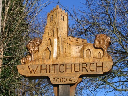
The walk starts at Whitchurch Village Sign, which was erected on New Year’s Day 2000 to mark the Millennium and carved by a local craftsman. Nearby is a bench, next to which is Infoboard 3.
Cache question 1: When did Ann Gaderen die? Answer: Ath June BCCA
Diagonally to your left (no need to cross the main road yet, just look) is the Methodist Church, built in 1844. It’s oak pews and pulpit were all made in the village and the organ was originally built for the Duke of Wellington.
To your left is The Old House. The original building was probably built in 1400 by monks of Woburn Abbey when they took over the parish church. At a later date it was divided into five separate dwellings (tenements) known as Lime Cottages until converted into one large house in the 1920s.
Walk down the path by the side of the Old House, along the High Street, and you come to the Old Courthouse. This building dates from 1360 and housed the courthouse until 1900. The village stocks were originally outside this building.
Further along the High Street is White Horse Lane. The building this is named after, on the corner, has been there since 1683 and is now a private house.
Walk up White Horse Lane and you come to St John’s Church. There has been a church on the present site since the end of the 10th century with the current church dating from the 13th century. The 14th century tower has a peal of six bells dating from the 17th and 18th century. Note also the large elaborate sundial. The Parish Map is on display inside the Church.
Cache question 2: What date is above the church door? Answer: DEFG
Leaving the churchyard by the same gate as you entered turn left, through the metal kissing gate, along the path and across the field towards the cricket ground. As you approach the next kissing gate look left towards Creslow Manor in the distance. It was reputed to have once had the largest field in the country. Named Creslow Great Ground, or Pasture, this field provided grazing for cattle which were supplied to the Tudor royal table. Creslow also contains the oldest domestic house in the county of Bucks. The current house was built in 1330 with 16th and 17th century additions. From 1939 until recently the masts of a Foreign Office radio station were visible in the fields of Creslow.
Walk past the cricket pavilion, through the five bar gate and through two more kissing gates. Following the path to the lane you come to a T junction. The circular walk continues to the right towards the main road. However weather (and time) permitting you may be able to take a quick detour to the left, over two stiles into the area where Whitchurch bricks were made until 1928. This is now a haven for wildlife. Return to the next waypoint via Bushmead Road.
Near where the footpath joins the main road was a duck pond and tradition has it that a ducking stool was used on the pond. Nearby is Infoboard 1.
Cache question 3: What was the address of the village doctor? Answer: H High Street
Crossing the road you come to The Firs. The current house was erected in 1897 on the site of an earlier building of the same name. The high wall was added in 1928. Between 1939 and 1946 The Firs housed the secret Ministry of Defence department MD1, known as Winston Churchill’s “toyshop”. Over 250 staff developed and produced 26 different types of weapons.
The road by the side of The Firs, is called Little London and was the centre of lace making and silk weaving in the village. These were prominent cottage industries in the 1800s.
As you walk back up the High Street Deerstalkers is on the right hand side. Now an antique shop it was once three cottages. Note the fine herringbone brickwork.
A little further up the street on the left is Winster Paddocks. This was a coaching inn as early as 1636. From 1914 until 1989 it was a butcher’s shop.
Just before the telephone kiosk turn left down the footpath. At the fork in the path if you take the left fork you will see Whittle Hole spring. This is one of many in Whitchurch and was the source of fresh water for the village up until recently. Go back and take the right fork, down the path and through the meadow to your right. To your left is a good view of the Vale of Aylesbury. Over the stream and stile and bear right, and by the big tree and little footbridge is…
Fair Alice Spring, which rises out from beneath the site of the old castle. It is reputed that this water has therapeutic properties. This small stream, which has never been known to dry up, joins with others and once powered a 26 foot diameter wheel at Dunn Mill at the bottom of Weir Lane.
Above you is the Castle Mound. Built in the 12th century by Hugh de Bolebec the castle was the largest of eighteen such castles in the county. It is reported that in 1264 it covered 6 acres. During the Civil War (1642 – 1651) it was destroyed on the orders of Oliver Cromwell. Evidence of the old stones can still be seen in many buildings in the village.
Continue through the field to the kissing gate beside the thatched cottage. Nearby is Infoboard 2.
Cache question 4: When was Dunn Mill first recorded? Answer: JKKL
Turn right into Castle Lane and turn left up Market Hill which was once the main street through the village. In 1245 the Earl of Oxford received a grant to hold a weekly market here and a yearly fair on the Monday of St John the Evangelist. This fair was resurrected in 1979 and is held on May Day and known as the May Feast.
When you reach the Oving Road continue up a little way before crossing the road to Crabsgrove. From here you can look back over to Bolebec House with its thatched barn. It was here that the celebrated artist Rex Whistler (born 1905) lived. From the garden of Bolebec House he painted the picture “The Vale of Aylesbury”, which is now held at the National trust property Upton House near Banbury. Whistler was killed in Normandy in 1944.
Turning back down the Oving Road you pass Whitchurch House dating from 1620. It was here that Joyce Anstruther (1901 – 1953), better known as “Jan Struther”, once lived. She is remembered for her book, Mrs Miniver, published in 1939 and later made into a major film. She was also the composer of many hymns, most notably Lord of All Hopefulness.
Down the road, before the roundabout, you see Old School House. In fact, this 16th century timber framed house, the building nearest the road, was the master’s house. It was restored in 1864 when the school, the brick building set further back, was built. The school is now the Legion Hall.
The final cache can be located at:
N51 52.(AxB)(C/E)(B+D)
W000 50.(G-F)(H+J+J)(L-(K-J))
If anybody would like to expand this series please do. I would just ask that you let Smokeypugs know first so they can keep track of the Village Sign numbers and names to avoid duplication.