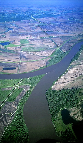
Platte River Confluence
Confluence: in geography, describes the meeting of two or more bodies of water. It usually refers to the point where a tributary joins a more major river.
The Platte River, mostly resides in Nebraska. This river is formed at the Nebraska town of North Platte, with the confluence of the North and South Platte rivers.

Source: http://earthobservatory.nasa.gov/IOTD/view.php?id=8105
“The Platte proper is 310 miles (500 km) long, but measured from its source stream, Grizzly Creek in Colorado (via the North Platte River), the system has a length of 990 miles (1,590 km).” (Platte River, 2013)
The Platte river confluences at the Missouri River at Plattsmouth, NE.
Source: http://lewis-clark.org/content/content-article.asp?ArticleID=2941
“The river named Platte — French for "flat" — drains nearly the entire state of Nebraska, whose name also means "flat," in the Omaha and Oto languages.” (Mussulman, 2009)
“The wide, flat valley of the Platte was a primary route of westward journeys in the mid-19th century; the Mormon and Oregon trails followed it. The river serves as an important part of the continental bird migration route, providing habitat for millions of migrating birds such as sandhill and whooping cranes. The Platte drains an area of some 90,000 square miles (233,000 square km). The vast quantities of water diverted for irrigation agriculture and municipal use are significant aspects of the Platte River system; more than a dozen dams regulate water flow and have significantly decreased the river’s width. The Loup and Elkhorn rivers are the main tributaries of the Platte.” (Platte River, 2013)
A river is defined as a natural watercourse, usually freshwater, flowing towards an ocean, lake, sea, or another river, which is the case here. Along a rivers length it may be joined by smaller rivers called tributaries; the two main tributaries of the Platte are the Loup and Elkhorn River’s. A river and its tributaries are contained within a drainage basin called the watershed.
Alluvium: material deposited by rivers. It is usually most extensively developed in the lower part of the course of a river, forming floodplains and deltas, but may be deposited at any point where the river overflows its banks
Sediment: is a naturally occurring material that is broken down by processes of weathering and erosion, and is subsequently transported by the action of wind, water, or ice, and/or by the force of gravity acting on the particles. For example, silt falls out of suspension via sedimentation and forms soil (some of which may eventually become sedimentary rock).
Sediments are most often transported by water (fluvial processes), wind (aeolian processes) and glaciers. Beach sands and river channel deposits are examples of fluvial transport and deposition, though sediment also often settles out of slow-moving or standing water in lakes and oceans. Desert sand dunes and loess are examples of aeolian transport and deposition.
Sediment transport: is the movement of solid particles (sediment), typically due to a combination of gravity acting on the sediment, and/or the movement of the fluid in which the sediment is entrained. Sediment transport occurs in natural systems where the particles are clastic rocks (sand, gravel, boulders, etc.), mud, or clay; the fluid is air, water, or ice; and the force of gravity acts to move the particles along the sloping surface on which they are resting. Sediment transport due to fluid motion occurs in rivers, oceans, lakes, seas, and other bodies of water due to currents and tides.
Suspended load: is the portion of the sediment that is carried by a fluid flow which settle slowly enough such that it almost never touches the bed. It is maintained in suspension by the turbulence in the flowing water and consists of particles generally of the fine sand, silt and clay size.
Schilling WMA
“This area was acquired in 1954 and developed by the Nebraska Game and Parks Commission with Pittman-Robertson funds from the federal excise tax on hunting equipment. Originally named Plattsmouth Waterfowl Management Area, the name was changed in 1980 to honor Randall W. Schilling, manager of the area, who died in a plane crash while on a deer survey along the Missouri River.
Since this is first and foremost a waterfowl management area, provisions for recreation are limited. However, visitors can enjoy fishing, picnicking, nature observation, wildlife photography and hiking. Other less common activities include horseback riding, archery and mushroom hunting.
Each fall, thousands of migrating waterfowl use the Schilling Area during their flight between their nesting and wintering grounds. Waterfowl populations sometimes peak in excess of 200,000 birds. Lesser snow geese are the most abundant migrants to use the area, but Canada, white-fronted and Ross' geese, along with several species of ducks, may also be observed.
The area is closed to all individuals not directly participating in the controlled waterfowl hunt or other Commission-authorized activities from Oct. 15-Dec. 31 of each year. The area reopens to hunting, in season, and other public access beginning January 1, unless otherwise announced.”(Schilling WMA, 2013)
This earthcache is only accessible April 1 through October 14 from 7 a.m. to 9 p.m.
**Logging requirements**
DO NOT POST ANSWERS IN YOUR LOG.
Send the following answers to me via email.
- The text "GC4MJEW Platte River Confluence" on the first line
- What type of Sediment is the bank of the Platte River made of along this area? Sand or Mud
- What’s the texture of Sediment along here and what colors are present?
- There is a pole here at these coordinates what is on top of it?
- Which river seems to flow faster and why do you think this is?
| I have earned GSA's highest level: |
   |