 Roche-A-Cri State Park is located in central Adams County, 1.5 miles north of Friendship and 1.5 miles south of the intersection of state highways 21 and 13. A small park of 605 acres, 25 of which are in the RAC Mound state natural area and 442 of which are in the RAC Woods SNA, Roche-A-Cri State Park provides for a diversity of plant and animal life, including the prairie restoration area located in the southern part of the park and the turkey vultures that ride the thermals above the mound. There are over six miles of trails in the park to enjoy, along with three picnic areas, two playgrounds, and a reservable open picnic shelter.
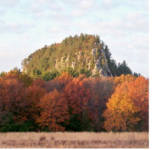
Dominating the park is the 300-foot sandstone Roche-A-Cri Mound rock outcropping that was once an island in glacial Lake Wisconsin. In 1994 a stairway to the top of the mound was constructed by the Wisconsin Conservation Corps, but because of weathering and vandalism that caused the deterioration of the building material, the stairway was closed for safety reasons in 2010, and new materials were used to rebuild the structure, which reopened in 2012. Visitors can climb the 303 steps to the viewing deck at the north end of the mound, but access is restricted to the structure to preserve the natural area on the top of the mound.
Roche-A-Cri has been a destination for travelers since early times when the first inhabitants of the region, who were perhaps the ancestors of the Ho-Chunk people, created petroglyphs and pictographs on the south face of the mound. Visitors can view and learn about this rock art from an accessible deck and interpretive panels in that location. Other early travelers were the French, who gave the mound its name of "Roche-A-Cri", which means "crevice in the rock", and Civil War soldiers, who camped here as they made the journey south to train for and go off to war. In 1937, the State Highway Commission gained control of the area as a roadside stop, and in 1948 the wayside park was transferred to the Conservation Commission and established as a state park.
Today's travelers can drive through the park on the 1.2 mile park road loop, spend a night at one of the 41 rustic campsites (four have electricity), visit the banks of Carter Creek, look for a variety of geocaches (RAC was the site of the 2010 WGA fall picnic), and otherwise enjoy all that this hidden gem has to offer.
NOTE: The cache itself is not in a hunting area, but hunting is allowed in parts of the park, including the area to the west of the trail that goes from the winter parking area on Czech Avenue across the prairie and into the woods. (See the map in the photo gallery for this cache page.) For current hunting dates and regulations for Wisconsin state parks, check out the DNR website here.
The Geocache Notification Form 2500-118 has been submitted to Park Manager Heather Wolf of the Wisconsin DNR. Geocaches placed on Wisconsin Department of Natural Resource managed lands require permission by means of a notification form. Please print out a paper copy of the notification form, fill in all required information, then submit it to the land manager. The DNR Notification form and land manager information can be obtained by looking at this page on the WGA website.
This region is right in the middle of our state, easy to get to from everywhere else. Its biome is sand plains and prairie. The landscape was largely shaped when it sat at the bottom of huge Glacial Lake Wisconsin, which left behind sandy soils and a fairly flat landscape. One still can find eroded sandstone buttes, believed to have been islands during this time period, and certainly striking features as one travels through the region. There are scattered mixed hardwoods and pine plantations, as well as large areas of wetlands and grasslands. Prairie Chickens do their spring dances in this region. The threatened Karner Blue Butterflies live here, as do river otters. Timber Wolves have reached their southern range in this biome.
WISCONSIN GEOCACHING ASSOCIATION
The Wisconsin Geocaching Association (WGA) is a group of geocachers dedicated to promoting and protecting geocaching within the state of Wisconsin. The WGA organizes geocaching events, works with land owners/managers on geocaching policies, educates the public at large about geocaching, and facilitates communication between WGA members. To learn more about the WGA visit www.wi-geocaching.com
2013 kicks off the beginning of the Wisconsin Geocaching Association State Parks series. It is our goal to place a geocache in every state park in the state of Wisconsin so watch out for more in this series that encourages geocachers to explore the natural resources in this beautiful state of ours.