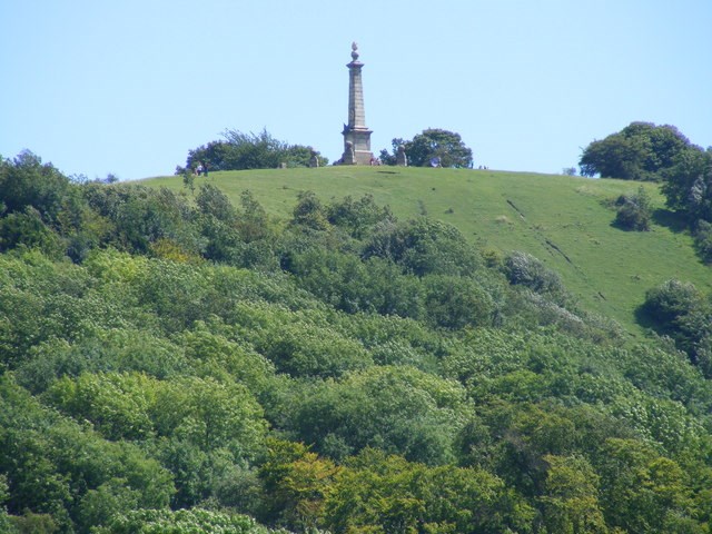
If you are reading this at the published co-ordinates you are just in front of Coombe Hill Monument, which stands at one of the highest points of the Chiltern Hills in the heart of the Chilterns Area of Outstanding Natural Beauty (AONB). This is an area that was once promoted by the Metropolitan Railway Company as ‘Metroland’ – an idyllic rural haven for those who wished to escape from the city to live in the country. The Chiltern Hills was designated as an AONB in the 1960s in order to conserve and enhance the special qualities of its landscape and to protect it from the spread of development from north-west London.
The hills are formed by an outcrop of chalk on the north-western side of the London basin. The chalk strata have been tilted to create a dip slope that rises so gently towards the north-west that it generally has the character of a plateau. However it ends abruptly in a steep slope, called a scarp, which forms the more dramatic north-western face of the Chilterns over which you are now looking.
Physical influences on the landscape
Chalk, laid down in deposits during the Cretaceous period (about 66 to 145 million years ago), dominates the solid geology of the Chiltern Hills. At the time the sea level was much higher than it is today and this entire area was immersed under water. Between them the three chalk layers, the upper chalk, middle chalk and lower chalk form a broad band thicker than the depth of the scarp on which you are standing.
The chalk is most apparent along the scarp face and in places has been used to form shapes in the hillside. The nearest of these is the cross at Whiteleaf although the most well known is the white lion at Whipsnade. The scarp, rising in places to over 250m, is formed by the middle chalk and upper chalk; lower chalk occurs in a band along the foot of the scarp forming the foothills between the scarp and the vale beyond.
Although chalk forms the basic skeleton of the landscape, it is often covered by other deposits with the result that there are large areas of the Chilterns where the landscape does not have the characteristic appearance of chalk scenery. This applies particularly to the plateau to the south east of here where the chalk is covered by a complex range of superficial deposits including extensive areas of clay-with-flints and more localised deposits of sand and gravel of unknown origin. These clays, sands and gravels are in many places covered by a thin, silty covering of loess (a sediment formed by the accumulation of wind-blown silt), that is thought to have been blown westward across southern England from the plains in the North Sea basin. The soils derived from these various plateau deposits are often acidic, resulting in vegetation that is very different from that which occurs on the chalky soils.
Human influences on the landscape
Prehistoric
Before human settlement the Chiltern Hills would probably have been covered by extensive forests, dominated by oak, ash and wych-elm. Evidence of early human subsistence has been found in the immediate area of Coombe Hill in the scatters of flint implements from the Mesolithic period (10,000-4,000 BC).
The Neolithic period (4,000-2,000 BC) saw the introduction of agriculture to the British Isles and the rapid spread of this innovation led to the widespread clearance of woodland – this was the most dramatic period of change in the history of your immediate surroundings. The scale of clearance in the Chilterns is difficult to establish but it is likely that woodland disappeared from much of the immediate area.
Earthworks such as hill-forts and dykes dating from the Iron Age (750 BC-43 AD) are common in the Chilterns. These are a by-product of the territorial disputes that were a feature of this period. Prominent hills were chosen as the sites for hill-forts; these are concentrated along the scarp of the Chiltern Hills and along the Thames Valley, thus commanding the two major lines of communication in the area. From the Monument on Coombe Hill you can clearly see Pulpit Hill to the south-west. This was the site of a small hill-fort, which was a simple structure surrounded by a single bank and ditch.
Medieval
Throughout the medieval period this area of the Chilterns was sparsely populated, and the scarp was mainly used for grazing livestock during the summer months. This system was known as transhumance: the seasonal movement of people and livestock to take advantage of optimum farming conditions. Coombe Hill, where you are standing, sits within Wendover parish, which covers nearly 6,000 acres including the clay vale, the spring line, the chalk scarp and the wooded, clay ridge. In such a large parish with a variety of land types the scarp could be kept clear of woodland so that it could be used for grazing.
The present day
Since the Tudor period the proximity of the Chilterns to London has become the single most important influence on its development. The area relied on the products of its woodlands and arable fields for income and what was not used locally was sent to London. The reliance of the area on its woods and arable fields ensured the continuing survival of a landscape originally established in the early medieval period. Only very recently has the tree line crept up the side of the scarp: photographs of Coombe Hill in 1913 show a much more barren landscape than that which can be seen here today.
The geocache
As this is an earth cache there is no physical container to find or log book to sign. Instead answer the questions below and send them via my profile link at the top of the page. Remember to check the box to include your email address for a response.
Any logs made without an accompanying email may be deleted without further notice.
Questions
- During which period of history was the chalk that makes up the skeleton of the Chiltern Hills laid down?
- How long ago was this area cleared of woodland for the purpose of agriculture?
- What is the altitude of Coombe Hill at the monument? Some GPS devices will provide this information; alternatively you can look it up on an Ordnance Survey map or via the Internet.
- Look at the soil around the monument (not the gravel). Describe what you see including type, drainage and likely pH. Please give reasons for your answer.
Please feel free to upload a photo with your log, though this is not required in order to claim a find.
I would like to offer my thanks to the National Trust for agreeing to the placement of this earth cache. Please help maintain the beauty and ecology of this amazing place by taking your litter home with you.