
 Deutsche Version (English version below):
Die eindrückliche Karstlandschaft der Schrattenfluh (etwa 6 km lang) ist ein Naturdenkmal von nationaler Bedeutung.
Entstehung
In der Atmosphäre wird der Regen mit natürlichem Kohlendioxid angereichert. Der Regen wird dadurch leicht sauer und frisst sich durch Ritzen in den Felsen, wodurch dieser gespalten wird.
Der Regen löst also den Kalkstein auf.
Mit andern Worten hier wurde und wird die Landschaft durch eine chemische Erosion verändert!
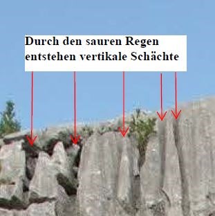
Normalerweise gibt es bei chemischer Verwitterung keine scharfen Kanten, da gerade solche Kanten kristallographisch sehr aktiv sind und sich als erstes auflösen.
Hier hat es aber messerscharfe Kanten ! Wieso ? Was passiert hier?
Hundertprozentige Sicherheit wird da niemand bekommen, aber sicher ist, das zufällige physikalische Effekte (wie Unebenheiten im Untergrund, Sand-Humus-bedingte "Stauwände") hier eine Rolle gespielt haben. Bei regelmässigem, aber nicht sehr starkem Regen, fliesst das Wasser immer nach dem geringsten Wiederstand, um Hindernisse herum, durch die tiefsten Rillen. Die chemische Auflösung war da am grössten, wo die Wassertiefe am tiefsten oder die Rille am breitesten war. Hier siehst Du ein chemisch präpariertes, 1000 x vergrössertes Abbild der ursprünglichen Regenablauf-kanäle. Wenn immer sehr viel Wasser geflossen wäre, wären auch die scharfen Kanten verschwunden.
Diesen Earthcache darfst du loggen, wenn du die folgenden Bedingungen erfuellt hast:
1.) Besuche die Karstlandschaft der Schrattenfluh (Koordinaten).
2.) Bei der Koordinaten siehst Du eine Felswand.
Zähle im obersten Teil der Wand die Anzahl Schächte / Rillen !
Links begrenzt durch die erste grossen Rillen (auf Bild mit Pfeilen: Erster Schacht / Rille von links !) bis Rechts zum Kletterhacken.
3.) Bitte Beschreibe diese Wand ?
4.) Optional: Bitte mache ein Foto vom Karstfeld (nicht von der Felswand !).
Bitte sende uns deine Antworten (Anzahl Rillen und Beschreibung der Wand) an unser Profil.
Du musst nicht auf die Antwort warten, wenn Deine Antwort nicht stimmt, melden wir uns
Achtung: Dieser Earthcache liegt an einem Bergweg und nicht an einem Wanderweg!
Bei Naesse und Nebel ist dieser Bergweg sehr gefaehrlich!
 English version (Deutsche Version siehe oben):
The karst landscape Schrattenfluh (approximate 6 km long) is one of the biggest in Switzerland.
Glacier and water formed here limestone pavement called Schrattenkalk.
Formation:
In the atmosphere, the rain is enriched with natural carbon dioxide. The rain becomes slightly acidic and erode the rock. So the rain dissolves the limestone. In other words, the scenery here was formed by chemical erosion.
By chemical erosion it is not usual that sharp edges still exist. Because the sharp edges normally erode firstly. The reason why you could see here very sharp edges are not 100 % clear. But it is sure that random physical effects (such as irregularities in the base, sand-humus-related "traffic jam walls) had an impact on this landscape. With regular, but not very heavy rain, the water always flows the easiest way, around obstacles, through the deepest grooves similar as in a rain channel.
Precondition to log this cache:
1.) Visited this landscape by the coordination.
2.) Here you will see limestone pavement and a cliff.
Please have a look to the top part of the wall. How many grooves could you see between the big groove (compare left arrow on the picture. This is the left border) and on the ride side till the climing hook (right border)!
3.) Please describe this wall.
4.) Optional: Please take a photo from the karst landscape (not from the wall!)
Please send us your answers (number of groove, and the description).
It is not necessary to wait. If your answers are not correct we will contact you.
Please pay attention: This Earthcache is on a mountain hiking trail.
The weather condition must be good, otherwise it is very dangerous to go to this location!