Il Passo della Mulattiera (2.412 m) Traditional Geocache
Il Passo della Mulattiera (2.412 m)
-
Difficulty:
-

-
Terrain:
-

Size:  (regular)
Please note Use of geocaching.com services is subject to the terms and conditions
in our disclaimer.
a piedi o in mountainbike
Passo della Mulattiera 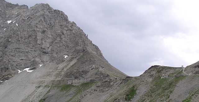
 Il passo della Mulattiera è un valico a sud di Bardonecchia vicino al confine italo-francese situato proprio sotto la bellissima parete rocciosa di Punta Charrà (2.844 m). Dall’alto dei suoi 2.412 metri il Passo della Mulattiera offre un panorama di straordinaria bellezza sulla Valle Stretta e su tutte le montagne circostanti la conca di Bardonecchia, Beaulard e Oulx. Il passo della Mulattiera è un valico a sud di Bardonecchia vicino al confine italo-francese situato proprio sotto la bellissima parete rocciosa di Punta Charrà (2.844 m). Dall’alto dei suoi 2.412 metri il Passo della Mulattiera offre un panorama di straordinaria bellezza sulla Valle Stretta e su tutte le montagne circostanti la conca di Bardonecchia, Beaulard e Oulx.
Accesso: Da Bardonecchia o Beaulard fino a poco sotto la Punta Colomion (ved relativo waypoint), dove entrambe le varianti si congiungono in una una vecchia carrozzabile militare verso il Passo della Mulattiera, seguendo i relativi segnavia.
E' anche possibile salire da Campo Smith in seggiovia fino al Pian del Sole (1.550m) e da lì a piedi o in mtb verso Colomion (2.050m). Le bici possono essere portate in seggiovia, è un bike park!
Il cache: E' taglia small ed è nascosto all'interno della Caserma XVI, costruita nel 1939.
 Il Passo della Mulattiera (mule track mountain pass) is a col in the south of Bardonecchia near the French-Italian border, located just below the beautiful cliff of Punta Charra (2,844 m). From it's height of 2,412 meters a.s.l., the Passo della Mulattiera offers you a great panoramic view on Valle Stretta (Vallée Étroite in french) and all the mountains surrounding the valley of Bardonecchia, Beaulard and Oulx. Il Passo della Mulattiera (mule track mountain pass) is a col in the south of Bardonecchia near the French-Italian border, located just below the beautiful cliff of Punta Charra (2,844 m). From it's height of 2,412 meters a.s.l., the Passo della Mulattiera offers you a great panoramic view on Valle Stretta (Vallée Étroite in french) and all the mountains surrounding the valley of Bardonecchia, Beaulard and Oulx.
Access: From Bardonecchia and Beaulard to the Punta Colomion (see related waypoint) where both variants joinand where you proceed on an old military road, following the signposts.
We'd suggest to take the chair lift up from Campo Smith, (see waypint parking in Bardonecchia) to Pian del Sole (1.550m) and from there on foot or by bike to Colomion (2.050m).
Bikes can be taken into the lift, it's a bike park!
The cache:Is a small sized one and is hidden inside the military barracks XVI, built in 1939.
 Il Passo della Mulatiera (Pass des Maultierpfades) ist ein südlich von Bardonecchia gelegener Gebirgspass in der Nähe der Französisch-italienischen Grenze direkt unterhalb der wunderschönen Steilküste von Punta Charra (2.844 m). Von seinen von 2.412 Metern aus bietet der Passo della Mulattiera ein außergewöhnliches Panorama auf die Valle Stretta (franz. Vallée Étroite, was "enges Tal"bedeutet) und die rund um das Tal von Bardonecchia, Beaulard und Oulx liegenden Berge. Il Passo della Mulatiera (Pass des Maultierpfades) ist ein südlich von Bardonecchia gelegener Gebirgspass in der Nähe der Französisch-italienischen Grenze direkt unterhalb der wunderschönen Steilküste von Punta Charra (2.844 m). Von seinen von 2.412 Metern aus bietet der Passo della Mulattiera ein außergewöhnliches Panorama auf die Valle Stretta (franz. Vallée Étroite, was "enges Tal"bedeutet) und die rund um das Tal von Bardonecchia, Beaulard und Oulx liegenden Berge.
Zugang:Von Bardonecchia oder Beaulard bis knapp unterhalb der Punta Colomion (siehe den Wegpunkt), wo dann beide Varianten in einer alten Militaerstrasse zusammenführen, welche dann den Hinweisschildern folgend zum Passo della Mulattiera führt.
Wir schlagen Euch vor, von Campo Smith (s. Waypoint Parkplatz in Bardonecchia) mit dem Sessellift hinauf zum Pian del Sole (1.550m) zu fahren und von dort zu Fuß oder mit dem Mountainbike zum Colomion (2.050m). Bikes koennen problemlos mit dem Lift mitgenommen werden, es ist ein Bikepark!
Der Cache: Ist Grösse small und im Inneren der sechzehnten Kaserne, welche im Jahre 1939 erbaut wurde, versteckt.
 Tenere sempre in considerazione le previsioni del tempo. Always keep an eye on the weather forecast. Tenere sempre in considerazione le previsioni del tempo. Always keep an eye on the weather forecast.

|
Additional Hints
(Decrypt)
[IT] crahygvzn svarfgen cevzb cvnab
[FR] ninag-qreavèer sraêger cerzvre égntr
[EN] arkg gb ynfg jvaqbj svefg sybbe
[DE] ibeyrgmgrf Srafgre refgre Fgbpx