Passo Giau EarthCache
-
Difficulty:
-

-
Terrain:
-

Size:  (other)
Please note Use of geocaching.com services is subject to the terms and conditions
in our disclaimer.
ITA.: Il Passo di Giau o, più comunemente, passo Giau (2.236m) è un valico alpino situato nelle Dolomiti, in provincia di Belluno.
DEU.: Der Passo di Giau ist ein 2.236m hoher Gebirgspass der Dolomiten in der italienischen Provinz Belluno.
ENG.: The Giau Pass (Italian: Passo di Giau) (el. 2.236m) is a high mountain pass in the Dolomites in the province of Belluno in Italy.

Storia geologica
La genesi di questo tipo di roccia carbonatica inizia attraverso accumuli di conchiglie, coralli e alghe calcaree e in ambiente marino e tropicale (simile all'attuale barriera corallina delle Bahamas, e dell'Australia orientale), i quali ebbero luogo nel Triassico, circa 250 milioni di anni fa, in zone con latitudine e longitudine molto diverse dall'attuale locazione delle Dolomiti, dove esistevano mari caldi e poco profondi. Sul fondo di questi mari si accumularono centinaia di metri di sedimento che, sotto il loro stesso peso e perdendo i fluidi interni, si trasformarono in roccia. Successivamente, lo scontro tra la placca europea e la placca africana (orogenesi alpina) fece emergere queste rocce innalzandole oltre 3000 m sopra il livello del mare. Il paesaggio attuale è spigoloso e ricco di dislivelli. A determinare tale trasformazione sono stati i piegamenti e le rotture delle rocce lungo piani di scorrimento (faglie), ai cui movimenti corrispondono altrettanti terremoti; episodiche esplosioni vulcaniche e relativi depositi; erosioni differenziali legate agli agenti atmosferici e ai piani di debolezza insiti nelle rocce. L'innalzamento delle rocce dolomitiche è tuttora in corso. Oggi le Dolomiti mostrano il biancore dei carbonati di scogliera corallina, l'acutezza di rocce coinvolte in orogenesi recenti, le incisioni di potenti agenti esogeni (ghiacciai, vento, pioggia, freddo-caldo). Nel futuro geologico, le Dolomiti continueranno a crescere inglobando nuovi settori di rocce sospinte dallo scontro tra le placche europea e africana (analogamente a quanto succede per la catena himalayana); la scomparsa di questa spinta determinerà il prevalere degli agenti esogeni tendenti ad appianare e addolcire il paesaggio montano.
Per registrare questa Earth Cache, la seguente questione deve essere risolta:
- quanti milioni di anni fa, ha causato delle Alpi (Dolomiti)?
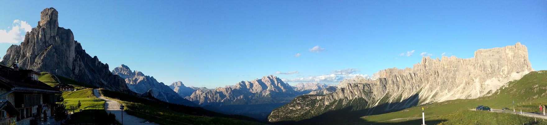
- Vattene a N 46° 28.955 E 012° 03 200. Qual è la differenza tra la forma grave della montagna che nel nord (circa 1 km) e sud (a destra di fronte a voi) vedere?
È possibile trovare la risposta per la domanda 1, ai koordinates intestazione.
Si prega di inviare la risposta a una e-mail sul mio profilo. È necessario attendere alcuna autorizzazione log dovrebbe essere qualcosa di sbagliato, mi metterò in contatto con.
Circa foto Sarei lieto, ma non condizione log.
Si prega di caricare una foto del pannello

Geomorphologie
Charakteristisch für die Dolomiten ist der abrupte Wechsel zwischen sanft gewellten Almen und den darauf sitzenden steilen Riffen aus Kalkstein und Dolomiten. Die Riffe ragen zum Teil bis in eine Höhe von etwa 3.000 bis 3.200 m. Interessant ist hierbei eine deutliche Terrassierung bei ca. 2300 m (Schlern) und 2800 m (Sella-Massiv). Auch die Fanes-Hochfläche oder die Gardenaccia-Crespaina-Hochfläche zählen zu diesen Terrassen. Im Kontrast dazu stehen die stark zerklüfteten Massive wie etwa Langkofel, Sextener Dolomiten und Rosengarten. Ursachen dieser unterschiedlichen Erscheinungsformen sind u. a. der stark gegliederte Schichtaufbau (gut zu sehen an der Rosengarten-Westflanke), die abwechselnde Hebung und Senkung ganzer Gesteinsblöcke mit unterschiedlichen Überflutungsphasen (sichtbar z. B. am Sellastock) sowie das Aufbrechen der geschlossenen Formationen durch Magmagänge. Das Gebirge besteht zu großen Teilen aus Sedimentgestein, das deutlich typische Schichtungen aufweist. Dazwischen findet man auch Lagen aus versteinerten Korallenriffen, die in der Tethys der Trias gewachsen waren. Dieses Gestein wird als Dolomit bezeichnet, dabei wird zwischen verschiedenen lithostratigraphischen Einheiten wie beispielsweise Schlerndolomit und auflagerndem Hauptdolomit differenziert. Auch vulkanische Spuren (Eruptivgestein) lassen sich entdecken: So findet man z. B. im Latemar tiefe Einschnitte in den Hauptkamm – nur wenige Meter breit, aber bis zu 200 Meter tief –, an deren Grund dunkles und kissenartig abgerundetes Lavagestein zutage tritt. Der kleine Padonkamm zwischen Sella und Marmolata besteht zur Gänze aus Lavagestein. Gegen das Etschtal hin finden sich ganze Hochflächen aus Porphyr.
Um diesen Earth Cache zu loggen, muss folgende Frage beantwortet werden:
- Vor wievielen Millionen Jahren entstanden die Alpen (Dolomiten)?
- Gehe zu N 46° 28.955 E 012° 03.200 und siehe dich um. Was ist der grobe Unterschied zwischen der Gebirgsform die du im Norden (ca. 1km) und im Süden (direkt vor dir) siehst?
Die Antwort auf Frage 1 findest du auf der Infotafel bei den Headerkoordinaten.
Schickt die Antwort bitte als Email über mein Profil. Ihr müsst auf keine Logfreigabe warten, sollte etwas nicht stimmen, werde ich mich mit euch in Verbindung setzen.
Über Fotos würde ich mich freuen, ist aber keine Logbedingung. Bitte keine Fotos von der Tafel hochladen!

geomorphology
Characteristic of the Dolomites is the abrupt change between gently rolling pastures and sitting on it steep cliffs of limestone and dolomite. The reefs extend in part to an altitude of about 3000-3200 m. Of interest is a significant terracing at about 2300m (Schlern) and 2800 m (Sella massif). In contrast to this are the highly rugged massifs such as Sasso Lungo, Sexten Dolomites and the Rosengarten (Rose Garden). Causes of these different manifestations, including the highly structured layer structure (good to see at the Rosengarten west flank), is the alternate rise and fall of entire mountain blocks of rock with different flooding phases (visible eg on the Sella) and the breaking up of closed formations by magma courses. The mountains consist largely of sedimentary rock that has clearly typical stratifications. In between you will also find layers of fossilized coral reefs that were grown in the Triassic Tethys. This rock is called dolomite, it is differentiated between different lithostratigraphic units, such as dolomite and Sciliar be outsourced Main Dolomite. Also volcanic tracks (igneous rock) can be discovered: Thus one finds, for example, in the Latemar, deep cuts in the main ridge - only a few meters wide, but up to 200 meters deep - at whose base rounded dark and pillowed lava comes to light. The small Padonkamm between Sella and Marmolada is composed entirely of lava stone.
In order to log this Earth Cache, the following question has to be answered:
- How many million years ago, the Alps (Dolomites) were originated?
- Go to N46° 28.955 E012° 03 200 and look around you. What is the big difference of the shapes of the mountains you see in the north (about 1km), and south (right in front of you)?
You can find the answer for question 1 at the header koordinates.
Please send the answer as email. You don't need to wait for logging permission. If something is wrong, I will contact you.
Pictures are welcome, but are not necessary.
Please do not upload a picture of the info board.
(Fonte/Quelle/Source: wikipedia.org)

Additional Hints
(No hints available.)