Warwickshire Feldon: Pittern Hill
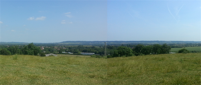
You are now standing on Pittern Hill. What you are looking at to the east and south is not a river valley - the Warwickshire Feldon (which simply means ‘fields’, ie not the forest of Arden) is a flat plain running broadly south-west from Rugby, and was last impacted by sedimentary processes in the Lower and Middle Jurassic age. Prior to cultivation then, the low areas were swamp and the higher areas forested, but humans have been impacting this landscape for well over 2,000 years.
In this earthcache you will learn a bit about the Feldon, how such areas are created, and what came of such processes – including life and death, battles and castles of nature, which complement the man-made history that has happened in this landscape in more recent times.
Orientation:
Look eastwards and you will see a small outcrop of uplands that is the Burton Hills, and further to the east, the Northamptonshire hills – can you spot Arbury Hill, a high point at 224m? Probably not in summer. Look south and that first area of uplands is Edgehill, with the Cotswolds much further behind and to the west. Behind Edgehill and to the east (left) is a gap between the Cotswolds and the Northamptonshire hills, and through this gap runs the river Cherwell, as well as the medieval road to London, the Oxford canal, the cross-country railway line, and M40. Behind you lie the uplands that housed the Forest of Arden, which is gone now but used to contain and surround the river valleys of the Dene and Avon. The battle of Edgehill happened in the plain below you, and the 2013 Geocaching mega event at the Motor Heritage Center to the east  .
.
Geology & Landscape:

The higher areas are largely mudstone and shale-based materials, with deeper sandstone and ironstone underneath. This whole area was once a fairly level shallow seabed perhaps 10-30m deep. Over time various fault lines have developed, pushing the hills up and exposing the harder rocks, which became the forests while the lower lying land turned to swamps. Since then glaciers came, they reached their maximum point only about 20,000 years ago and then retreated, leaving lots of 'drift skim' to form the surface that you see in front of you - in this area this is largely boulder clay. Even the farmed landscape that you see today is also historic – predating the Romans when in the Iron Age the Dobunni Celts drained and cultivated the lowlands. At the foot of Pittern Hill lies the town of Kineton, which is on the River Dene, which itself joins the River Avon in Wellesbourne (behind you).
Two Battlefields!

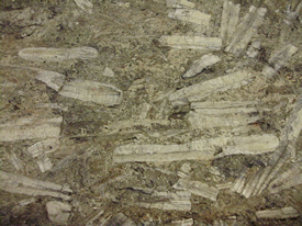
In the lower and middle Jurassic eras this part of England was about 10° further south, thus the climate was warmer and wetter – and sealife thrived! The main evidence we have of the nature of this life comes from the calcium shells left behind, mainly creatures known as ‘belemnites’. We know this because we can still see their shells in the stones in the outcrops – such as at Starveall Barn and Edgehill – these sites are known in the trade as “belemnite battlefields”, due to the vast number of these dead creatures found in patches of the local stone such as Hornton stone, quarried from these outcrops. Edgehill was the site of a later battle, which has also left some small imprint on the land in the form of musket pellets – I wonder how future geologists will interpret these?
The outcrops formed natural ‘castles’ within these swamp areas, and the stone from them often ended up in the walls of actual castles in the area. Broughton Castle is 16km (10miles) from here, and is a fine example of such a structure, where you can see this stone for yourself.

The Earthcache
Please answer the following questions in order to claim the cache. Email your answers to earth@sharant.com and optionally post a picture of you showing the landscape (try bringing a friend and have them stand very far back to take the picture using a zoom lens – this will bring a far hill into your shot for a nice effect).
- send us your answers via the link in our profile page - do not post the answers to your log; any logs containing answers may be deleted by the CO.
Questions to answer:
- This landscape is Lower and Middle Jurassic. When was that?
- Using your GPS device, tell me the altitude of where you are now on Pittern Hill.
- How high is Edgehill, where the quarries were? It’s the hill across the Feldon there to the south. You can either use a map or travel there and take a measurement (see waypoint for a suggested place to measure from).
- When rain falls here, on this hill where you are standing, which major river does the water flow into? Your choices are: into the River Trent, Nene, Thames, or Severn, and the answer is almost but not quite on this page in the description above – you may need to think about that or look something up…

- Are you really here? Let's see. As you walked up the hill the nature of the soil changed, as you left the Feldon and entered the area that was once the Forest of Arden. Try to describe the difference in the nature of the soil from the bottom of the hill to the top - more or less tiny stones? Darker or lighter soil? Which is richer? And in one sentence can you therefore give a theory for what reason forest may have been cleared (look around you!)?
We'd love you to post a photo of yourself or your party here please!
Waypoint – reference point: what is the approximate altitude of the Edgehill Quarries?
References: