This cache is part of a series dedicated to those Organ Saints. Each cache displays some quality which typifies an Organ Saint. By finding all caches of the series and recording the codes found in each one, you will be able to unlock the location of the final and join the ranks of the saintly.
One thing that always must be kept in mind when exploring the Organ Mountains is how you will be getting down. Even if you are tackling a route with known descent options, it is good to be prepared for the unexpected. There are many reasons you may be forced to bail at almost any point in your adventure, and if you happen to be up in a high cliff band, having the proper equipment is an absolute necessity. Even if you are not planning on doing something requiring rappelling, it is good to have some anchor material and a small rope and rappel device with you. This is especially true if you are planning an expedition with little or no route information. Also, when you are using known descent routes, you will often find that existing anchor material has been degraded by the sun, wind and rocks to an unsafe condition, and thus requires replacing to use.

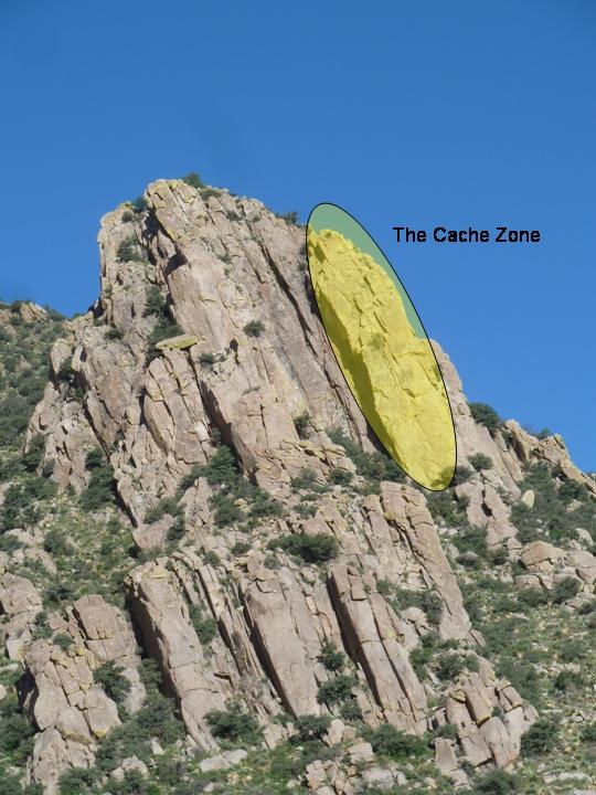
This cache takes you to an area that rarely gets explored on the Eastern side of Baylor peak, all the more reason to visit it. Stage 1 is the top of a small spur, and is an altoids tin hidden in the rocks and marked by a cairn (spoiler picture available below). Here you will find coordinates for the final as well as the top rappel station. Bring enough rope to perform two 30m rappels (CAUTION: Make sure you use stopper-knots to keep from rappelling off the end of your rope). Also make sure you have 20ft of your own webbing to replace the anchors if it looks like they have been weathered beyond use. Climbers will often add a piece of their own webbing to existing anchors and you are welcome to do so. But when using this practice, make sure you remove the oldest, rattiest looking material from the anchor so as to keep it from becoming a mass of tangled and unkempt tat. Always double-check your anchor before trusting it for the rappel. The final is an ammo can tied to the roots of a Mexican buckeye tree and halfway down (or up) the cliff. Original contents include a set of Purcell Prussiks, handy for any mountaineer and especially useful for roped rescue work, a bag of rock-climbing holds and T-nuts, an LED flashlight, a matchstick container and some climbing stickers. BRING YOUR OWN PEN/PENCIL. The one I was planning to leave in the cache was accidentally dropped.
While this cache is located ~1 mile from the Aguirre Springs rd, the approach may end up feeling like much more due to the ample amounts of cats-claw acacia on these slopes. The difficulty rating for this cache is due largely to this trying approach. If you find a good way to reach these cliffs post about it so others may follow. After rappelling down from the cache, there is a nice shady spot free from brush to relax and enjoy your success. NOTE: There is a day-use fee of $5 in this area (unless you approach from the west side of Baylor Peak. Even if you do not go all the way up to the Aguirre Picnic area, please make sure you stop by the Campground Host and pay the fee, or display your annual pass on your car windshield.