©#4 Rocca Clarì - Batteria B13 Traditional Geocache
©#4 Rocca Clarì - Batteria B13
-
Difficulty:
-

-
Terrain:
-
Size:  (regular)
Please note Use of geocaching.com services is subject to the terms and conditions
in our disclaimer.
Non cercare alla coordinate del listing, potrebbe diventare pericoloso. Per trovare il cache seguire il WP "Entrata BatteriaB13" e poi il hint.
Do not look for the cache at listing's coordinates but follow WP Entrance of the Battery and then the hint.
Den Cache nicht an den koords des Listings suchen sondern dem WP Eingang des Bunkers folgen und dann dem hint.
 (©#4) (©#4)
 «Rocca Clarì - Il Bunker "Batteria B13"» «Rocca Clarì - Il Bunker "Batteria B13"»
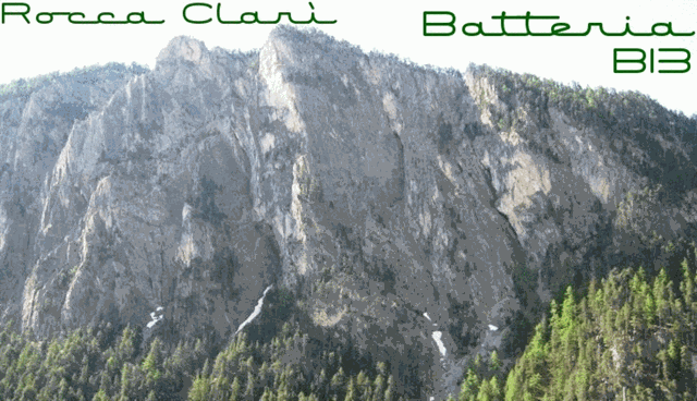
La Rocca Clarì (2051 m), pur non essendo una delle montagne conosciute ed importanti della valle, è sicuramente una di quelle più sovente ammirate, in quanto il suo versante NO precipita in modo imponente e selvaggio nella valletta della Piccola Dora (Gorge di San Gervasio) ed è pertanto ben visibile percorrendo la Strada Statale del Monginevro, tra Cesana T.se e Claviere.
A causa della posizione strategica sul colle del Monginevro, la Rocca Clarì e ricca di strutture belliche abbandonate facenti parte di una vecchia linea difensiva delle seconda guerra mondiale. La maggiore di queste è la batteria B13, chiamata anche 609° Batteria G.a.F. (Guardia alla Frontiera), costruita tra il 1931 e 1932 e dotata di tre cannoni 75/27 e tre o 4 mitragliatrici in grado di battere la zona di Claviere e addirittura il Colle Gimont. Ospitava un equipaggiamento fisso di 46 soldati e per le sue dimensioni notevoli (il corridoio centrale è lungo quasi 100 mt), più che una normale batteria sembra una specie di centrale di commando.
Accesso:Con comoda passeggiata di ca 45 minuti partendo da Claviere e passando da località La Coche (destinazione degli impianti sciistici) con il suo lago artificiale.
Altrimenti passi di qui al termine della Via Ferrata Rocca Clarì.
In entrambi i casi si passa prima dal cache "Rocca Clarì - la sommità", (©#3) e da lì prendere il piccolo sentiero che parte dietro alla casetta.
Buon divertimento!
 «Rocca Clarì - the bunker "Battery B13"» «Rocca Clarì - the bunker "Battery B13"»
The Rocca Clari (2051 m a.s.l.), although is not one of the well known and important mountains of the valley, is certainly one of those most often admired, as his side Nort-Western rockface falls down steep and impressively into the Piccola Dora's valley (Gorge of San Gervasio) and is therefore clearly visible while travelling on the Monginevro highway between Cesana Torinese and Claviere.
Because of its strategic position on Montgenevre alpine-pass, on Rocca Clarì exist several abandoned war structures which were part of a defensive line in World War II. The largest of these is the battery B13, also known as 609th Battery GaF (Border Guard), built between 1931 and 1932. It had three canons 75/27 and three or four machine guns capable of beating the area of Claviere and even Colle Gimont. It had a fix equipment of 46 soldiers and due to its considerable size (the central corridor is almost 100 meters long), more than a normal battery it seems a kind of command center.
Access: With an easy walk of about 45 minutes starting from Claviere and mpassing by La Coche (destination of ski-lifts) with its artificial lake.
Otherwise you'll pass here while returning from the end of the Via Ferrata Rocca Clarì.
In both cases, first switch to the cache "Rocca Clari - La sommità, the summit" (© # 3) and then take the small path that starts behind the lodge.
Have fun!
 «Rocca Clarì - Der Bunker "Batterie B13"» «Rocca Clarì - Der Bunker "Batterie B13"»
Die Rocca Clari (2051 m ü.d.M.), ist wohl nicht unter den bekannten und "wichtigten" Bergen des Tales, aber sie ist sicherlich einer der am häufigsten bewunderten, da ihre Nord-West Felswand steil und imposant in das Tal der Piccola Dora (Schlucht von San Gervasio) stürzt und daher deutlich sichtbar ist wenn man auf der Bundestrasse von Monginevro zwischen Cesana Torinese und Claviere reist.
Aufgrund der strategischen Lage nahe des Montgenevre-Passes, befinden sich auf der Rocca Clarì einige aufgegebene militaerische Strukturen, welche Teil einer alten Verteidigungslinie aus dem zweiten Weltkrieg sind. Die größte von ihnen ist die Batterie B13, auch 609° Batterie des GaF (Grenzschutz) genannt. Sie wurde zwischen 1931 und 1932 erbaut und verfügte über drei Kanonen 75/27 und drei oder vier Maschinengewehre in der Lage die gegend um Claviere und sogar Colle Gimont zu beschiessen. 46 Soldaten waren hier fest stationiert und Anhand der beträchtlichen Größe (die mittlere Korridor ist fast 100 Meter lang), kann man davon ausgehen, das mehr als eine normale Batterie, eine Art Kommandozentrale gewesen sein könnte.
Zugang: Nach angenehmem Fussmacrsch von etwa 45 Minuten ab Claviere und vorbei an La Coche (Ziel der Lifte) mit seinem künstlichen See.
Alternativ kommt Ihr hier auf dem Rückweg nach der Via Ferrata Rocca Clarì vorbei.
In beiden Fällen erst den Cache "Rocca Clari - La sommità , der Gipfel" (© # 3) angehen und dann dem kleinen, hinter dem Häuschen beginnenden Weg folgen.
Viel Spaß!
 
|
Additional Hints
(Decrypt)
Ragen qnyyn srffhen qrfgen. Cnffrm à geniref yn sragr à qebvgr. Ragre guebhtu gur evtug penpx. Qhepu qra erpugra Fcnyg ervatrura.
▲ (± 90 cnffv/fgrcf)
► (±40 cnffv/fgrcf)
► (±80 cnffv/fgrcf)
Cbv frthv yn yhpr r yb gebirenv nyyn ghn fvavfgen, b aba pncvfpv cebcevb ha ghob? Fhvirm rafhvgr yn yhzvèer rg ibhf yr gebhirerm n yn tnhpur, cvcr. Gura sbyybj gur yvtug naq lbh'yy svaq vg ba gur yrsg, cvcr. Qnaa sbytr qrz Yvpug haq qh svaqrfg vua mhe Yvaxra, Ebue.