(SI) Tomaževa miza je zagotovo morfološko - po videzu - kot tudi po geoloških danostih, ki so botrovale njenemu nastanku, eden najzanimivejših naravnih pojavov pri nas.
PRED ZAČETKOM:
Prosimo preberite opis tega geološkega zaklada in si zapišite naloge za vpis se pred obiskom v naravi!
NALOGE ZA VPIS OBISKA
1. Plošča mize je od podstavka ločena zaradi lezike - prekinitve med plastmi dolomita. Ozrite se na kamnito steno jugovzhodno od mize in poskusite tudi tam najti leziko.
1a. Oglejte si strukturo kamnine nad in pod leziko. Ali vidite kakšno razliko?
1b. Kaj pa material same lezike? Kako izgleda? Udarite po njem s kamnom ali kladivom, potem storite enako na dolomitu nad leziko. Ste ugotovili kakšno razliko?
2. Izračunajte približno maso plošče Tomaževe mize. Ste dovolj močni, da jo zazibljete?
POMEMBNO!
- Preden vpišete obisk zaklada, pošljite odgovore preko GC profila ali neposredno na e-naslov vane.si.geo@gmail.com. Takoj potem lahko vpišete obisk zaklada na spletu – ne potrebujete dodatnega dovoljenja. Če ste fotografirali, prosimo, priložite kakšno fotografijo.
- Vpisi brez ustrezne spremljajoče e-poste, ki vsebuje pravilne odgovore, bodo najprej trajno kodirani, kasneje izbrisani!
- Vpisi, ki vsebujejo odgovor bodo izbrisani!
(ENG) Stone table (originally: Tomaž's table) is one of the most interesting natural phenomena in this region of Slovenia –taking the morphology (shape) and geological events that helped to form it into account.
BEFORE THE BEGINNING:
Please read the description of this EarthCache and write down logging tasks before visiting the EarthCache site!
LOGGING TASKS
1. Table plate became detached from its column because of the bedding plane - interrruption between the dolomite rock layers. Take a look at the cliff to the southeast of the table and find the bedding plane there.
1a. Can you see any difference in the rock structure above the bedding plane and beneath it? the dolomite rock.
1b. What about the material of the bedding plane itself? How does it look like? Hit it with a rock or a hammer, then do the same to the rock above the bedding plane. Is there any difference?
2. Calculate the approximate weigth of the stone table plate. Are you strong enough to rock it?
IMPORTANT!
- Send answers through GC profile or directly to e-mail vane.si.geo@gmail.com
before logging. After that you can log - you don't need an additional permission to log. Please, upload photos if you have taken them.
- Logs without an accompanying e-mail containing correct answers will be encrypted and later deleted!
- Logs containing the answer will be deleted!
slovensko besedilo / Slovenian text
tocke poti in dnevniki / waypoints and logs
Visit our web-site Geološki zakladi / EarthCaches
for a complete list of our EarthCaches and a lot of additional information.
(ENG) THE TABLE
Formed and shaped by nature, this 'stone table' is assembled from thick rocky plate, which rests at the top of a narrow, also rocky pillar. The plate actually lies at the top of the pillar and is not firmly bound to it. The size of the plate is 4,7 times 4.3 m and has very irregular edges. It is about 1,6 m thick. The supporting stone pillar measures about 2,5 m across and is about 1,2 m high at the lower side.
Middle Triassic Anisian dolomite builds stone table and its surroundings as well. Dolomite of Idria region is usually uniform (not-stratified) or weakly stratified. The dolomite is uniform in the surroundings of the table too, but you can see strong, distinct BEDDING PLANE (the flat surface separating two parts of rock) in the rock wall to the east of the table. This bedding plane has played an important role in the formation of the table. We could divide the table formation process into three phases.
PHASE 1: ROCK FORMATION
The table formation has already been made possible in the time of the dolomite rock formation – in Anisian, more than 240 million years ago. Lower part of dolomite, which forms the supporting pillar, is less durable, fine-grained dolomite rock. The interruption of sedimentation (of material from which dolomite has been formed) followed. This interruption is now visible as previously mentioned distinct bedding plane. Above this plane new sedimentation followed, but then more coarsely-grained dolomite has been formed, which is more resistant to wear and erosion.
PHASE 2: THE FAULT
The dolomite unit which includes stone table lies in the Podklanec fault zone. This fault zone has already been formed in Triassic. The fault is part of so-called Zavratec bundle of Triassic faults, with the west-east direction (Čar, reference No.3). Triassic faults are also called ‘normal faults’. Tension along those faults caused rock units to subsidize - some faster and some slower.
Podklanec fault with two forks has been formed in the Middle Triassic tectonic phase. In the narrow stripe along both fault zones dolomite has been crushed, while about 30 m wide dolomite block in the middle has remained less fractured. But this middle block, containing rock above and under bedding plane, has slightly subsidized.

Figure 1: Clipping from tectonic map (Čar, J., 2008) and Map of ... (Čar, J., 2010).
Three of four “bundles” of Triassic faults of Idrija-Cerklje hills are presented. Clipping shows the smaller area with Buhčeve rupe and Tomaž’s forest – Tomaž’s Table is located there, beside Podklanec falult (position is marked with red circle).
PHASE 3: EROSION
In the recent geological time, erosion has removed the crushed rocks along both fault forks fast, while the middle, less fractured block started to stand out from the surroundings. But also the middle block has not remained untouched. All this time the atmospheric water erosion has been removing un-fractured, but less resistant dolomite lying under the bedding plane faster than the dolomite above.
The bedding plane is strong, but it probably only consisted of some soft marl stone, which has easily disintegrated and been removed. This caused the dolomite plate of the table to ‘float’ at the top of the pillar. Since the contact plane of the plate and pillar is very small, and there is not much friction, you can even slightly rock the plate while standing or hanging on the plate edge.
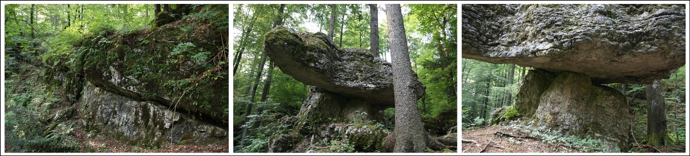
Figure 2: Photos from left to right: clearly visible “bedding plane” (interruption)n in the rock cliff, southeast from The Table, The Table, plate is touching the pillar at only few spots.
ACCESS
Stone table stands near Ravne pri Žireh village. When you manage to find the main road in the valley between Žiri and Rovte, you will have no problem to find the EarthCache with the help of waypoints, and some wooden direction signs at the end. Park your car just after the last farm in Ravne pri Žireh and walk the rest of the way. It is a pleasant walk across the meadow at first and through the forest in the last stretch.
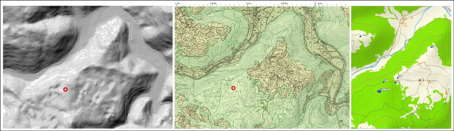
Figure 3: Tomaž’s table is marked with red circle at the relief map (clipping from web atlas Geopedia) and topographical map (clipping from the Atlas of environment). There are waypoints of the trail to The Table marked at the topographic map at the right side (Adria Topo)
Note: You use trails at your own risk. Be safe and enjoy!
REFERENCES
1. Čar, J., 2004: Personal archive.
3. Čar, J., Mlakar, I., 2010: Geological map of the Idrija – Cerkno hills between Stopnik and Rovte, 1 : 25.000.
3. Čar, J., 2010: Geological structure of the Idrija – Cerkno hills, Explanatory book to the Geological map (reference No. 2).
4. Photos: Vane Krajšek, 2012.
Slovensko besedilo
Obiscite naso spletno stran Geološki zakladi / EarthCaches
za seznam vseh nasih Geoloških zakladov in mnogo dodatnih podatkov.
(SI) MIZA
Naravno oblikovana velika 'kamnita miza' je sestavljena iz debele kamnite plošče, ki se nahaja na ožjem, prav tako kamnitem, stebru. Plošča je samostojna in s stebrom ni trdno povezana. Plošča je velika 4,7 x 4,3 m in ima zelo razgibane in nepravilne robove. Njena debeline je cca 1,6 m. Kamniti podstavek ima premer okrog 2,5 m in je visok okrog 1,2 m na nižji strani.
Tomaževa miza z okolico je zgrajena iz srednjetriasnega anizijskega dolomita. Dolomit je na Idrijskem običajno NEPLASTNAT ali slabo PLASTNAT. Dolomit je neplastnat tudi v okolici mize, v steni na vzhodni strani pa je opaziti močno in izrazito prekinitev v kamnini - LEZIKO (plastnato površino), ki je imela pomembno vlogo pri nastanku mize. Nastanek mize lahko razdelimo v tri faze.
1. FAZA: NASTAJANJE KAMNINE
Nastanek kamnite mize je bil zasnovan že v času nastajanja same dolomitne kamnine, v aniziju, pred več kot 240 milijoni let. Spodnji del dolomita, v katerem je nastal steber mize, je iz manj obstojnega drobnozrnatega dolomita. Sledila je prekinitev sedimentacije – usedanja gradiva iz katerega je nastajal dolomit. Ta prekinitev se kaže kot izrazita, prej omenjena lezika. Nad njo se je ponovno odložilo gradivo, iz katerega pa je nastal bolj debelo kristalast dolomit, ki je tudi bolj odporen proti razpadanju.
2. FAZA: PRELOM
Dolomitni blok, v katerem se nahaja Tomaževa miza, leži v prelomni coni Podklanškega preloma, ki je nastala že v davni preteklosti – v TRIASU. Prelom pripada tako imenovanemu Zavraškemu snopu triasnih prelomov, ki potekajo v smeri vzhod-zahod (Čar, vir 3). Triasni prelomi so posebni prelomi, ki jih imenujemo tudi 'normalni prelomi'. Ob njih so vladale natezne razmere ob katerih so posamezni kamninski bloki spuščali ali zaostajali. Na vzhodnem obrobju Buhčevih Rup je v času srednjetriasne tektoske faze nastal Podklanški prelom z dvema krakoma. V ožjem pasu ob obeh prelomnih conah je bil dolomit zdrobljen, vmesni dolomitni blok, širok približno 30 m, se je nekoliko pogreznil in je zajel kamnine nad in pod prekinitvijo (leziko). Kamnina v pogreznjenem bloku pri tem ni bila tektonsko pretrta.
Slika 1: Izseka iz tektonske karte (Čar, J., 2008) in geološke karte idrijsko-cerkljanskega hribovja med Slika 1: Stopnikom in Rovtami v merilo 1:25 000 (Čar, J., 2010). Prikazani so trije od štirih snopov triasnih prelomov na idrijsko-cerkljanskem območju. Na izseku geološke karte pa območje z Buhčevimi rupami in Tomaževo gmajno, kjer je ob Podklanškem prelomu tudi Tomaževa miza (pozicija označena z rdečim krogom).
3. FAZA: EROZIJA
Erozija je v zadnjem geološkem obdobju hitreje odnašala zdrobljeno kamnino ob obeh prelomnih conah, srednji, manj pretrti del pa je postopno izstopal iz okolice. Ob tem so atmosferilije hitreje 'glodale' tudi nepretrti, a manj obstojen dolomit srednjega dela pod leziko, kamnino nad njo pa počasneje.
Ker je lezika močna in je bilo morda v njej odloženo le nekaj mehkega laporovca, ki je hitro razpadel in bil odnesen, je dolomitna plošča 'zaplavala' in se le na zelo majhni površini dotika stebra. Na stiku je trenje tako majhno, da lahko ploščo na rahlo zazibljemo.
Slika 2: Fotografije od leve proti desni: izrazita lezika - prekinitev v skalni steni jugovzhodno od mize, Tomaževa miza, podstavek ali steber in naleganje plošče na nekaj točkah.
DOSTOP
Tomaževa miza se nahaja v Buhčevih Rupah nad dolino Žirovnice, jugozahodno od Raven pri Žireh. Avto pustite takoj za kmetijo _____ in se naprej odpravite peš po kolovozu. S pomočjo točk poti in nekaj smerokazov boste zlahka našli pot do mize.
Slika 3: Z rdečim krogom označena lokacija Tomaževe mize na reliefu (izsek iz spletnega atlasa Geopedia) in topgrafski karti (izsek iz spletnega Atlasa okolja). Desna topografska karta (Adria topo) ima označene točke poti do mize.
Opomba: Poti uporabljate na lastno odgovornost! Hodite le po poteh za katere ste ustrezno pripravljeni! Zelimo vam varno pot in veliko uzitkov!
VIRI:
1. Čar, J., 2004: Osebni arhiv.
2. Čar, J., Mlakar, I., 2010: Geološka karta idrijsko-cerkljanskega hribovja med Stopnikom in Rovtami v merilu 1:25 000.
3. Čar, J., 2010: Geološka zgradba idrijsko–cerkljanskega hribovja. Razlaga h karti idrijsko-cerkljanskega hribovja med Stopnikom in Rovtami v merilu 1:25 000.
4 Fotografije: Vane Krajšek, 2012.
tocke poti in dnevniki / waypoints and logs