Vous vous engagez de votre propre initiative dans la recherche de cette cache à vos risques et périls. Nous déclinons donc toute responsabilité en cas de problème.
Attention : 
Cette série de 7 eartcaches n’est accessible qu’à marée basse. Il n’y a pas d’autres entrées ou sorties possibles entre le trailhead 1 et le trailhead 2. Il vaut mieux y aller 2 heures avant la basse mer complète. Il est impératif de consulter le lien vers les horaires des marées pour ne pas risquer votre vie !!!!!
Horaires des marées Crozon Morgat
Warning :
This series of seven eartcaches is only accessible at low tide. There are no other possible entrances or exits between the trailhead 1 and the trailhead 2 . It is better to go two hours before low tide . It is imperative to check the link to Tide Times not to risk your life!!
Tide Times of Crozon Morgat

La presqu’île de Crozon est une région très favorable pour l’étude des séries paléozoïques du Briovérien (Protérozoïque terminal) au Dévonien, en particulier le long des falaises et sur l’estran. Elle constitue la partie occidentale du Massif Armoricain et s'intègre dans l'évolution géodynamique de la marge nord-gondwanienne.
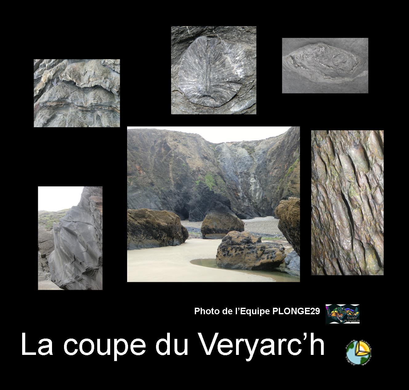
La coupe du Veryarc’h, commune de Camaret-sur-Mer, est une référence mondiale pour l’Ordovicien et la base du Silurien. Cette coupe que l’on peut visualiser depuis la pointe de Pen Hir, permet d’observer en continu (avec cependant quelques accidents tectoniques) l’empilement de plusieurs formations géologiques, de l’Arenig (Ordovicien inférieur) au Ludlow (Silurien supérieur), soit plus de 50 millions d’années d’archives sédimentaires marines et paléontologiques. Elle sera complétée à l’est par les coupes de Lamm Saoz et la Tavelle.
Nous vous proposons donc, au travers de ces 7 earthcaches,
de découvrir ce site en faisant une balade de 50 millions d’années sur 1,5 km
(de – 470 à - 420 millions d'années)
Crozon peninsula is a very favorable region for the study of Paleozoic series of Brioverian (Proterozoic) to the Devonian, particularly along the cliffs and on the foreshore. It forms the western part of the Armorican Massif and fits into the geodynamic evolution of the North Gondwana margin.
The Veryarc'h section, town of Camaret sur Mer, is a world benchmark for the base of the Ordovician and Silurian. We can see this section from the "Pointe de Pen Hir". This section (with however some tectonic accidents) shows the stack of several geological formations, of the Arenig (Ordovician) to Ludlow (Upper Silurian), more than 50 million years of archives marine sedimentary and paleontological.
We offer, with 7 Earthcaches
to discover this site by walking for 50 million years on 1,5 km
(from 470 million years ago to 420 million years ago)
 Questions pour valider : # 7 / 7
" La coupe du Veryarc'h : Formation TAVELLE "

Graptolites (1) : Groupe d'animaux marins surtout pélagiques dont les restes ressemblent à des traits de crayon plus ou moins dentelés. Ils apparaissent au Cambrien et sont connus jusqu'au Carbonifère : ce sont de bons fossiles stratigraphiques.
Coraux (2) : Espèces ayant un squelette calcaire et appartenant au groupe des cnidaires.
Bivalves (3) : mollusque dont la coquille est constituée de deux parties distinctes et attachées, plus ou moins symétriques, pouvant s'ouvrir ou se refermer.
Brachiopodes (4) : Organismes à coquille bivalve apparus au Cambrien et vivant encore aujourd'hui dans les mers peu profondes, fixés au substrat par un pédoncule.
Graptolithina (1) : Group of marin animals pelagic especially whose remains resemble pencil lines more or less jagged. They appear in the Cambrian and until the time of Carbonifère : they are good stratigraphic fossils.
Corals (2) : Species with a calcareous skeleton belonging to the group of cnidarians.
Bivalvia (3) : molluscs whose shell consists of two separate parts and tied, more or less symmetrical, opened or closed.
Brachiopod (4) : this are organisms that are with a bivalve shell appeared in the Cambrian and they are still living in the shallow seas, attached to the substrate by a pedicel.
Point 1: N 48° 15.586 W 4° 36.152
1 : Que voyez-vous à vos pieds à ces coordonnées ?
1: What do you see at your feet with these coordinate?
Point 2: N 48° 15.553 W 4° 36.143
Cherchez les fossiles ?
2 : Quel type de fossile est-ce ?
3 : Quelle est leur longueur moyenne en cm ?
Find fossil ?
2: What type of fossil is this?
3: What is the average length in cm?
Point 3: N 48° 15.554 W 4° 36.150

Trouvez le fossile qui est dans le cercle jaune de la photo ? ?
4 : Quel type de fossile est-ce ?
5 : Quelle est sa longueur en cm ?
Find the fossil who is in the yellow circle in the picture? ?
4: What type of fossil is this?
5: How much does it measure in cm?
-0-0-0-0-0-0-0-0-0-
Vous pouvez vous loguer sans attendre notre confirmation,
mais vous devez nous envoyer les réponses par mail en même temps: EQUIPE PLONGE29
S'il y a des problèmes avec vos réponses nous vous en ferons part.
Les logs enregistrés sans réponses seront supprimés.
(une photo de vous ou de votre GPS sur place sera la bienvenue, mais n'est pas obligatoire).
You can log the cache without our confirmation, but you should
send us answers at the same timeby e-mail: EQUIPE PLONGE29
If there is anything wrong with your answers we will let you know.
Logs without sending answers will be deleted.
( a picture of yourself or your GPS on site would be welcome but is not mandatory ).
-0-0-0-0-0-0-0-0-0-
La formation TAVELLE
La formation de la Tavelle ( âge : Wenlock-Ludlow, début du Silurien) se caractérise par des ampélites pyriteuses riches en graptolites. Il y a ensuite un contact faillé avec des ampélites à nodules calcaires et à petits bancs de quartzites contenant également des graptolites caractéristiques du Ludlow.
On retrouve la Formation du Cosquer en écaille tectonique pour ensuite découvrir des schistes à quartzites noirs se terminant par un niveau à nodules calcaires contenant des graptolites, des bivalves et des nautiloïdes. Le milieu de sédimentation est une plate-forme peu profonde et anoxique.
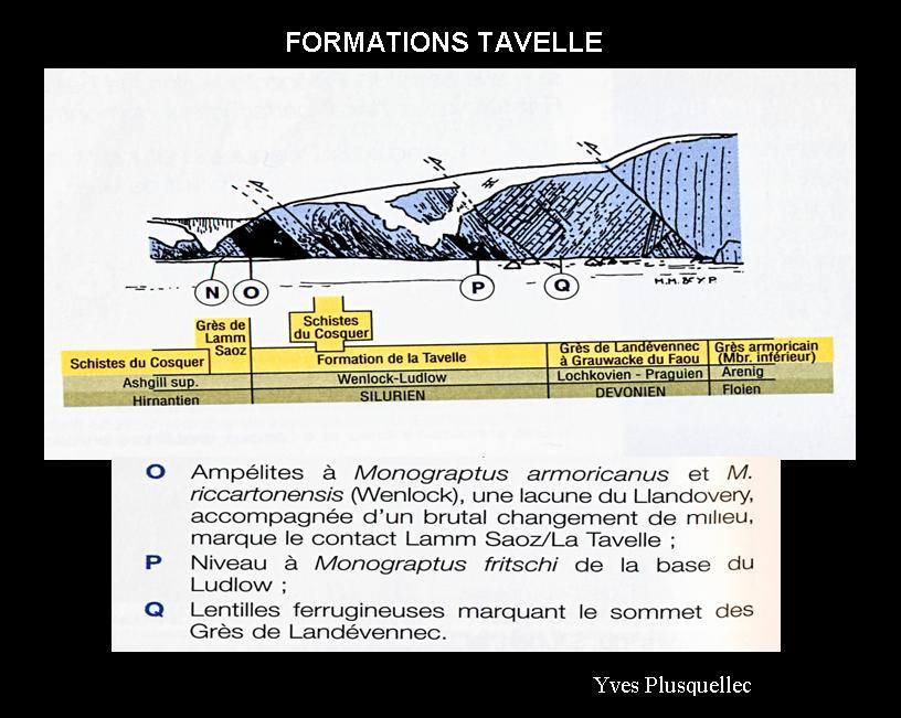
Ensuite s’observe un des chevauchements majeurs de la presqu’île de Crozon où le Silurien est en contact avec le Dévonien inférieur (Lochkovien-Praguien) c’est-à-dire avec les formations des Schistes et Calcaires de l’Armorique et des Grès de Landévennec.

Formation de l'ampélite :
Au Silurien (444 à 416 millions d'années) des sédiments argileux (pélites) se sont déposés dans une mer calme. Puis est intervenue la surrection de la Chaîne varisque (chaîne de montagne hercynienne) (350 à 300 millions d'années). Les sédiments ont alors été enfouis sous forte pression et haute température, subissant ainsi un métamorphisme modéré. Ce milieu confiné réducteur (pauvre en oxygène) a préservé le plancton et autres matières.
TAVELLE'S Formation
Tavelle's formation (age: Wenlock-Ludlow, Early Silurian) is characterized by pyritic black shales rich in graptolites. Then there is a faulted contact with black shales with calcareous nodules and small banks also quartzite containing graptolites characteristics of Ludlow.
We find the Cosquer's formation as tectonics slices and then find black quartzite schists ending with a level calcareous nodules containing graptolites, bivalves and nautiloids. The sedimentary environment is a shallow anoxic platform.
( O ) :Ampelite Monograptus armoricanus and Mr. riccartonensis (Wenlock), a lacuna of Llandovery, accompanied by a sudden change of environment, marks the contact Lamm SAOZ / the Tavelle
( P ) : level Monograptus fritschi base Ludlow
( Q ) : ironstones lentils that mark the top of the Landevennec sandstone
Then observed a major overlap of the Crozon peninsula where the Silurian is in contact with the Lower Devonian (Lochkovian-Pragian) that is to say, with shale and limestone of Armorica's formation and Landevennec's sandstone.
Ampelite's formation :
Silurian (444 to 416,000,000 years ago) clay sediments (pelites) were deposited in a calm sea. Then occurred the uplift of the Variscan orogeny (Hercynian mountain chain) (350 to 300 million years). The sediments were then buried under high pressure and high temperature, thus undergoing a moderate metamorphism. The gear contained (oxygen-poor) preserved plankton and other materials.
-0-0-0-0-0-0-0-0-0-
Rappel :
Sur les "earthcaches", il n'y a ni boîte, ni logbook. Il vous suffit de vous rendre sur place et de répondre aux questions du propriétaire de celle-ci. Vous lui faites parvenir vos réponses en le contactant par mail dans son profil sur Geocaching.com, en cliquant sur "send message" .
Reminder:
On 'Earthcaches', there is neither box nor logbook. Just go there and answer the owner's questions. Send your answers via email by contacting him on his profile on Geocaching.com, click on 'send message'
Très bon géocaching