BLACK SHEEP
Video: http://www.youtube.com/watch?v=wX2sGL1ZIjY&hd=1
A presença de gados nas zonas altas da Ilhas da Madeira e do Porto Santo aconteceu desde os primórdios da colonização e destinou-se ao sustento das populações. A falta de predadores naturais levou a que o homem negligenciasse o acompanhamento dos rebanhos, deixando os animais soltos e entregues à sua sorte. Entretanto, a ocorrência de incêndios florestais e o corte clandestino de espécies de grande valor da floresta indígena, ao longo de séculos, também contribuíram para o aumento do espaço territorial desses gados, que desde muito cedo foram causadores de problemas gravíssimos.
Sem planificação e sem sustentação técnica, ou seja, em zonas inadequadas, soltos e asselvajados, sem rotação e com excessivas e descontroladas cargas animais em razão das disponibilidades alimentares, a presença dos gados foi sempre incompatível com a preservação e sustentabilidade dos ecossistemas. Mas os animais foram sendo mantidos e como testemunho da grande quantidade que apascentou livremente nas serras, o “Eco do Funchal”, de 27 de Janeiro de 1946, noticia a existência de 95.000 cabeças assim classificadas: 55.000 ovelhas, 25.000 cabras e 15.000 porcos.
Apesar de terem representado um complemento à subsistência das populações, a evolução que foi acontecendo, fez com que os gados das serras perdessem importância nos dias de hoje. Deixaram de existir proprietários de gado que se dedicassem exclusivamente a ter animais nas serras ou que deles dependessem para sobreviver, mantendo-os apenas por capricho e quase não se deslocando às serras para realizar as tarefas relacionadas com eles. A maioria dessas pessoas desenvolvem actividades profissionais sem qualquer relação com o sector agrícola e os que são agricultores a criação de gados nas serras não era a sua actividade principal.
Em contrapartida a esta actividade desregrada, muitas foram as tentativas para a sua organização e disciplina, tendo sido lavrados diplomas no sentido de controlar a ocorrência de gados selvagens na floresta. Apesar de todo o empenho, foi difícil reprimir os interesses e as resistências dos proprietários dos gados e até 1980 a presença de animais soltos pelas serras continuou a fazer-se sentir por grande parte do Território, abrangendo aproximadamente 51.400 hectares.
A retirada definitiva de ovinos e caprinos de áreas com excessiva carga animal e sem ordenamento e de áreas sem aptidão para a pastorícia, foi fundamental para o ordenamento em detrimento da desordem e contribuiu para o estabelecimento do equilíbrio biofísico das áreas de intervenção. A recuperação do coberto vegetal dessas áreas é imprescindível para a protecção dos solos e infiltração das águas, assim como, a expansão dos espaços de vegetação autóctone, nomeadamente a floresta Laurissilva, é essencial para a manutenção do equilíbrio hidrológico, por ser a principal responsável pela captação da água dos nevoeiros. Também por ser detentora de elevada biodiversidade e de paisagens deslumbrantes, a floresta Laurissilva é uma das imprescindíveis atracções turísticas da Madeira, com o seu reconhecimento internacional a reflectir-se no facto de ser classificada como uma Reserva Biogenética do Conselho da Europa, como um Sítio da Rede Natura 2000 e como Património Mundial Natural sob a égide da UNESCO.

The presence of cattle in the highlands of the islands of Madeira and Porto Santo took place since the beginning of colonization and was intended for the people's livelihoods. The lack of natural predators led man to neglect the monitoring of herds, leaving the animals loose and to their fate. Meanwhile, the occurrence of forest fires and illegal cutting of valuable species of indigenous forest, over the centuries, have also contributed to the increase in the territorial space of these cattle, which caused on an early stage, very serious problems.
Without planning and without technical support, ie, in unsuitable reas, loose and wild without rotation and with excessive and uncontrolled stocking compared to the availability of food, the presence of cattle has always been incompatible with the preservation and sustainability of ecosystems. But the animals were being kept and as a witness of the large amount that grazed freely in the mountains, the "Eco Funchal" of January 27, 1946, reports the existence of 95,000 heads classified as follows: 55,000 sheep, 25,000 goats and 15,000 pigs.
Although they have represented a complement to the livelihood of the people, evolution has caused the cattle of the mountains to lose relevance nowadays. Livestock owners who have devoted themselves exclusively to animals in the mountains or who depended for their survival ceased to exist, keeping them just on a whim and hardly went to the mountains to perform tasks related to them. Most of these people developed professional activities unrelated to the agricultural sector and those who were farmers did not herd catle in the mountains as their main activity.
In contrast to this lawless activity, there were many attempts to its organization and discipline, having been issued laws in order to control the occurrence of wild cattle in the forest. Despite all efforts, it was difficult to suppress the interests and strengths of the cattle owners and until 1980 the presence of animals loose in the mountains continued to be felt on a large part of the territory, covering approximately 51,400 hectares.
The permanent removal of sheep and goats in areas with excessive stocking and without planning and in areas not suitable for shepherding, was crucial to the planning and contributed to the establishment of the biophysical equilibrium of the interventioned areas. The recovery of vegetation in these areas is essential for the protection of soil and water infiltration, as well as the expansion of areas of native vegetation, including the Laurel forest, it is essential for maintaining the hydrological balance, being the most responsible for capturing the water from fog. Also as the holder of high biodiversity and stunning scenery, the Laurel forest is one of the essential tourist attractions of Madeira, with its international recognition reflected in the fact that it is classified as a Biogenetic Reserve of the Council of Europe, as a Site Natura 2000 and as a World Natural Heritage under the aegis of UNESCO.
Adaptado de / adapted from:
http://www.sra.pt/DRF/index.php?option=com_content&view=article&id=105:pastoricia-retirada-de-ovinos-e-caprinos-evolucao&catid=49:pastoricia&Itemid=85
CACHE:
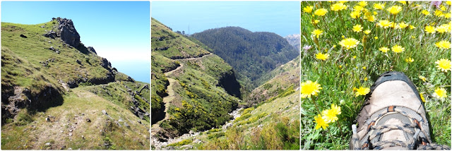
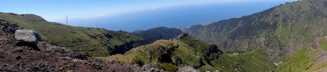
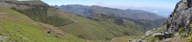
Esta cache desenrola-se em 4 stages que conduzem o geocacher para a cache final, ao longo de uma área que apresenta não só uma boa paisagem como também marcas da actividade pastorícia.
This cache plays out at four stages leading the geocacher to the final cache along an area which has not only a good scenery but also traces of shepherding activity.
 STAGE 1
Esta stage irá te indicar a coordenada para a stage seguinte.
Entra na gruta e responde à seguinte questão:
Quantas divisões podes encontrar no corredor principal desta gruta?
This stage will show you the coordinates to the next stage.
Enter the cave and answer the following question:
How many divisions can you find in the main hallway of this cave?
2 = N 32º 43.956 / W 17º 03.806
4 = N 32º 43.949 / W 17º 03.786
6 = N 32º 43.895 / W 17º 03.807
STAGE 2
Esta stage irá te indicar a coordenada para a stage seguinte.
Responde à seguinte questão:
O que é que encontras aqui?
This stage will show you the coordinates to the next stage.
Answer the following question:
What do you see here?
gruta/
cave= N 32º 43.937 / W 17º 03.891
pedra grande/
big rock= N 32º 43.953 / W 17º 03.863
curral/
corral= N 32º 43.930 / W 17º 03.869
STAGE 3
Esta stage irá te indicar a coordenada para a stage seguinte.
Responde à seguinte questão:
O que é que encontras aqui?
This stage will show you the coordinates to the next stage.
Answer the following question:
What do you see here?
gruta/
cave= N 32º 43.880 / W 17º 03.070
cascata/
waterfall= N 32° 43.893 W 017° 04.075
curral/
corral= N 32º 43.930 / W 17º 03.080
STAGE 4
Esta stage irá te indicar a coordenada para a stage seguinte.
Responde à seguinte questão:
O que é que encontras aqui?
This stage will show you the coordinates to the next stage.
Answer the following question:
What do you see here?
gruta/
cave= N 32º 43.917 / W 17º 04.154
pedra grande/
big rock= N 32º43.935´W 017º04.018
curral/
corral= N 32º 43.811 / W 17º 04.110
STAGE FINAL
Apenas precisas de retirar um pedra.
O container é frágil, trata-o com cuidado e deixa-o coberto e em boas condições.
You only need to remove one stone.
The container is fragile, treat it carefully and leave it covered and in good condition.
ATENÇÃO / ATTENTION:
- O percurso deverá ser feito com boas condições climatéricas e com pouca nebulosidade para que possas usufruir das paisagens proporcionadas.
- Deverás levar água e comida, roupa e calçado apropriados.
- Total: 2,6km, 50 minutos
- The course must be done with good weather conditions and with little clouds so you can enjoy the scenery.
- You should bring food and water, appropriate clothing and footwear.
- Total: 2,6km, 50 minutes