Das Fischlandkliff - Hohes Ufer Fischland EarthCache
Das Fischlandkliff - Hohes Ufer Fischland
-
Difficulty:
-

-
Terrain:
-

Size:  (other)
Please note Use of geocaching.com services is subject to the terms and conditions
in our disclaimer.
Das Fischlandkliff - Hohes Ufer Fischland
Achtung: Steilküsten sind gefährliche Gebiete! Bitte beachtet die Hinweise an den Infotafeln und bleibt auf den Wegen!
Witterungsbedingt kann der Zugang zum Strand nicht möglich sein!
Attention: cliff-terrain is dangerous! Please respect the warnings of the informations-points and walk only by the way!
Sometimes is the way down to beach not available by the weather!
Warnschilder Quelle: Informationstafel LUNG M-V
Update 05.06.2017:
Die Infoafel musste dem Küstenabbruch weichen und ist nun umgezogen. Wegpunkt neu gesetzt.
The information board is transferred to a new waypoint.
Update 29.06.2016:
Sollte die Treppe zur Station3 nicht verfügbar sein, dann bitte den alternativen Wegpunkt nutzen!
Update 06/29/2016: If stairs unavailable, please use the other waypoint to access station3.
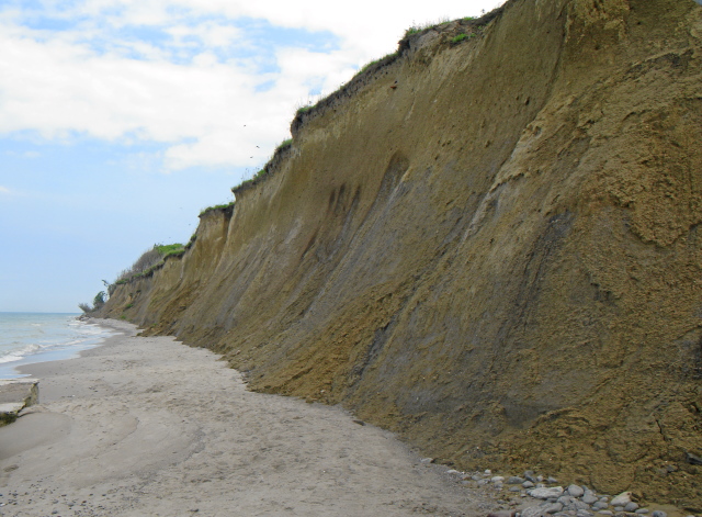
Das Fischland-Hochufer bildet das markante, bis zu 20 Meter hohe Kliff zwischen Wustrow und Ahrenshoop. Es gilt als das am meisten von der Abtragung betroffene Ufer an der Ostseeküste von Mecklenburg-Vorpommern.
Die Steilküste bietet hier einen Schnitt durch die Geologie des Fischlandes.
The "Fischland" high bank forms the distinctive, up to 20 meters high cliff between Wustrow and Ahrenshoop. It is considered the most affected by the erosion of the shore of the Baltic Sea coast of Mecklnburg-Vorpommern.
The cliff offers a section through the "Fischland" geology.
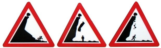
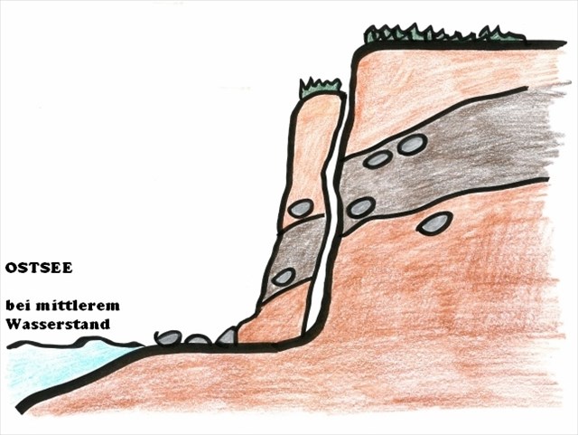
Steilküste - Modell / cliff - model
Fischland Hohes Ufer / cliff "Fischland Hohes Ufer"
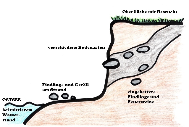
Das Hohe Fischland ist ein Inselkern aus eiszeitlichen Ablagerungen wie Schmelzwassersanden, Dünensand, den der Wind über die Kliffkannte geweht hat und Geschieben. Deutlich sind an der Küste die Sedimente der Eiszeit, wie Sand- und Kiesdrusen sowie Findlinge im Kliff zu erkennen.
The "Hohe Fischland" is an island-core of glacial meltwater deposits such as sand, sand dunes, the wind has blown over the cliff edge and boulder clay. You can see the glacial sediments.
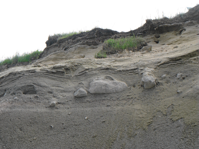
Findlinge / stones
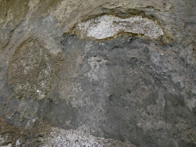
Sedimente / sediments
An diesem besonderen Ort ist es auf engstem Raum möglich, den kompletten geologischen Aufbau des Fischland-Kliffes zu sehen. Durch die starke Dynamik im Erosionsprozess sind die geologischen Schichten stets klar abgegrenzt zu erkennen.
Die anschauliche Erklärung an Station 1 lässt sich am Strand direkt nachvollziehen.
At this particular site, it is possible in a confined space, to see the complete geological structure of the "Fischland-Kliff". Crossing the strong momentum in the process of erosion can be seen always clearly defined the geological layers.
The clear explanation at station 1 can be traced directly on the beach.
Die Erosion der Küste erfolgt durch 3 verschiedene Prozesse, welche ihr hier sehr gut beobachten könnt.
Coastal erosion is performed by three different processes that you can watch your very well here.
1. Rutschungen:
Zwischen den Schichten Geschiebemergel und Geschiebelehm kommt es bei starker Feuchtigkeit zu Quellungen, wodurch es dann zu Rutschungen des Materials kommt.
1. landslide:
Between the layers of glacial till and boulder clay occurs when humidity to swell, which then leads to landslides of material.
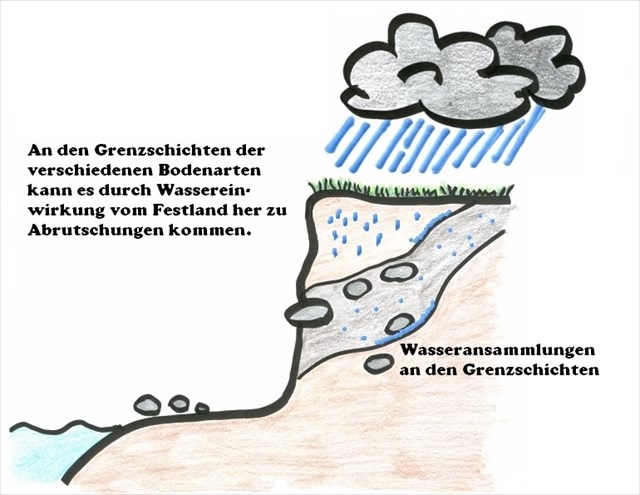
Ursache Abrutschung / cause of landslide
Abrutschung / landslide
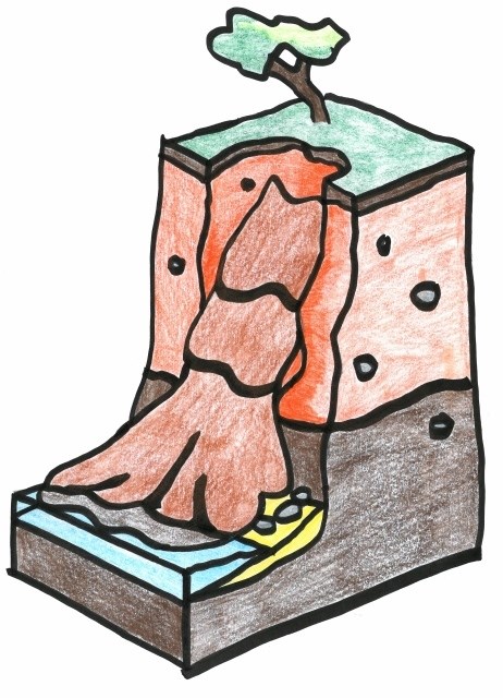
2. Abbrüche
Es gibt 2 Ursachen von Abbrüchen des Kliffs.
Die erste Ursache sind starke auflandige stürmische Winde, welche die Ostsee bis ans Kliff herandrücken. Dadurch wird der Sockel des Kliffs unterhöhlt. Ist diese Destabilisierung groß genug, dann gibt die Kliffkante unter ihrem eigenen Gewicht nach und bricht runter.
The first is caused by strong onshore stormy winds, which push up the approach to the Baltic Sea Cliff. Thus, the base of the cliff is undermined. This destabilization is large enough, then there the cliff edge under their own weight and breaks down.
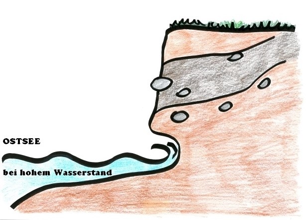
Kliff im Sturm / cliff in storm
Abbruch nach Sturm / material breaking after storm
Die zweite Ursache ist das Zusammenspiel von Wasser und Frost im Winter. Dafür gibt es an der Station 1 eine Beschreibung. Den dort genannten Begriff bitte unter Antwort 3 nennen.
The second cause is the interaction of water and frost in winter. There are at Station 1 a description. The specially term for that please answer for question 3.
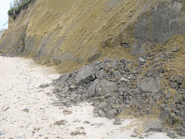
Abbruch am Fischlandkliff / material breaking at "Fischlandkliff"
Die am Strand angehäuften Lockermassen werden alsbald vom Meer abgetragen und am Darsser Ort angelagert.
The sediments will go away with the draft to "Darsser Ort".
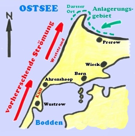
Strömung / flow
Bilder / Skizzen: black-tomcat
Quelle: Infotafel der Gemeinden Wustrow und Ahrenshoop
source: Infotafel der Gemeinden Wustrow und Ahrenshoop
Nach eurem Besuch am Hohen Ufer Fischland und der Beantwortung der Fragen per Mail an uns über GC-Profil dürft ihr sofort loggen.
Freiwillig: Wir würden uns sehr über ein Foto von euch, eurem GPS, eurem Maskottchen...vor oder am Kliff / Strand freuen!
Sollten die Antworten Unstimmigkeiten enthalten, werden wir uns bei euch melden.
Fragen:
Station1: 1. Wie weit weicht die Küste jährlich durch die Abtragung hier zurück?
Station1: 2. Bitte nenne die 5 geologischen Materialien von oben nach unten (blau markiert)
Station1: 3. Was ist die Ursache für Abbrüche im Winter?
Station3: 4. Bestimme die Dicke der einzelnen geologischen Schichten.
After your visit to the "Das Fischlandkliff - Hohes Ufer Fischland" and answering questions by mail to us via GC profile you may now log.
Optional: We would be very happy about a photo of you, your GPS, your mascot ... before the cliff or by the beach!
If the answers contain discrepancies, we will contact you.
Questions:
Station1: 1. How retreat the coast here in one year?
Station1: 2. Please enter the 5 geological materials from top to bottom (blue markered)
Station1: 3. How is the name of cause, when the material breaking down in winter?
Station3: 4. Determine the thickness of the geological layers.
Plant für diesen Cache etwa eine Stunde ein.
Plans for this cache about an hour.

Additional Hints
(Decrypt)
[Sind alle Fragen richtig, dann erhaltet Ihr in unserer Antwortmail einen Bonus!]