The signs can be made of different materials from fibreglass to wood, from forged steel to stone. They can depict anything from local industry to historical events. The tradition probably stated in Norfolk or Suffolk and has now spread across most of the country so cachers Smokeypugs thought they would base a series on them!
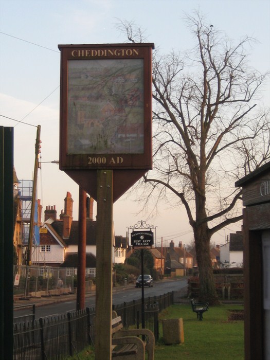
This sign is painted and depicts village scenes, but unfortunately it is behind glass and is hard to see. It was erected in 2000 to mark the Millennium.
Cheddington is situated 10 miles to the east of Aylesbury, Buckinghamshire. To the south west, West End Hill is designated as a local landscape area.
Known in ancient times as Cetendone, Cheddington is mentioned in the Domesday Survey of 1086. For centuries most men worked in agriculture. Cheddington was noted for its orchards and when the railway arrived in 1838, the station handled more plums than passengers! Although the last remaining orchard is still there, it is no longer maintained and the land has recently been divided and sold off as separate lots.
The latest census statistics indicate that the Cheddington ward - which includes Horton and Slapton - had 626 households and a population of 1,555.
To find this cache, locate the parish map which is close to the sign and extract numbers from it as follows:
A - the footpath that leads towards Mentmore
B - the footpath to the airfield industrial estate
C - the footpath that crosses the swing bridge at Great Seabrook and continues South east
D - the footpath from the allotment gardens through the orchard
E - the number of the bridlepath plus the the number of the footpath that crosses into the neighbouring Marsworth parish
The cache can be found at N 51° 50.ABC W 000° 39.DCE