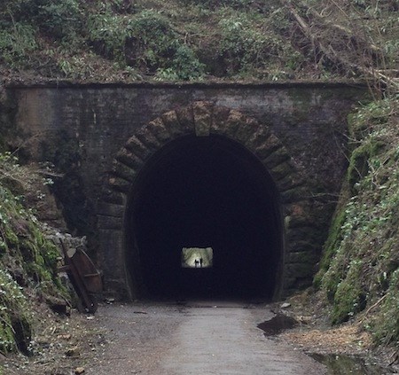
Shute Shelve tunnel is a disused railway tunnel that runs through the Mendip Hills.
The Strawberry Line (so named because of the large amounts of strawberries that were transported from Cheddar) was a part of Great Western Railway that was closed to passengers in 1963 in the Beeching Cuts. It now forms a (mainly traffic free) 10 mile railway walk from Yatton to Cheddar and is part of the National Cycle Network route 26.
The surface through the tunnel is tarmaced but unlit except for a central guide line of small solar powered "cat's eyes" which are automatically switched on by pedestrians or cyclists entering the tunnel.
Wheelchair accessible if approached from The Strawberry Line (parking at Axbridge or Winscombe), otherwise there is nearby parking at Kings Wood, but this is NOT wheelchair accessible.
Take a torch with you so that you can see how the tunnel walls change as you walk through it (just watch out for the bikes!). You will also see large areas of exposed tufa, which have been designated as a Regionally Important Geological and Geomorphological Site (RIGS).
The Mendip Hills are a range of limestone hills in Somerset which are largely formed from Carboniferous Limestone and are the most southerly range of hills of this type in the UK.
Tufa is composed of calcium carbonate and is commonly found around springs, former waterways, and other lakes with lots of dissolved minerals, but in this tunnel is due to the limestone from the hills dissolving into the groundwater which is subsequently dripping into the tunnel at specific points.
Tufa forms some fascinating shapes (you will see if you remembered your torch) which is due to the processes of erosion and deposition and sometimes the remains of plant life can be found in fresh tufa.
To log this Earthcache, please email or message me (via my profile) with the answers to the following questions:
1) How do the tunnel walls change as you walk through it from north to south and why do you think this change occurs?
2) And what distance into the tunnel does this change happen (from the north entrance)?
3) The colour of tufa is usually brown or yellow. What do you think causes the brown colour?
Thank you to North Somerset Council for giving me permission to place geocaches along the Strawberry Line as well this Earthcache (no physical container) in the tunnel, which is a SSSI.
Bats may be roosting in the tunnel - please do not disturb them.
In Britain all bat species and their roosts are legally protected, and it is a criminal offence to disturb them (Bats and the Law)
From the guidelines: "People do not need to wait for permission to log your EarthCache. Requiring someone to wait is not supported by the EarthCache guidelines. People should send their logging task answers to you, then log your EarthCache. When you review their logging task answers, if there is a problem, you should contact them to resolve it. If there is no problem, then their log simply stands."