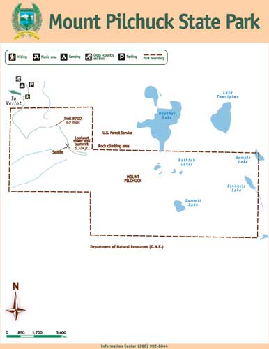
Located off the Mountain Loop Highway and visible from I-5, the Mount Pilchuck state park is 1,893-acres of hiking delight. The park includes sub-alpine lakes (Bathtub, Summit, Pinnacle) and many mountain trails, one ending at a fire lookout.
Just an 1.5 hour drive from Seattle, Mount Pilchuck is quite popular with the weekend crowds drawing 28,000 visitors annually. The number one draw for the mountain is the old fire lookout on the summit, which was constructed in 1918 by the US Forest Service and in service until the 1960's. The lookout building is on the National Historic Building register and was restored by the Everett Mountaineers in 1977. It is now a museum with historical pictures on display of the trail and lookout construction with maps that help you name the surrounding peaks.
In addition to the lookout, during the late 1950's through early in the 1970's there was a ski area on the mountain. The Mt. Pilchuck Ski Club started the area with one rope tow but by the time it stopped operating there were three tows, two chairs, a lodge and a rental shop. Snowfall was inconsistent from year to year and eventually this led to the USFS not renewing the permit for the operation of the ski area. In 1979, the lifts were closed and the equipment was moved to Crystal Mountain.
The trail up Mount Pilchuck is accessible for most of the year if you are so inclined but be aware that during the winter months there will be snow, sometimes quite a bit and you should be prepared for winter conditions. The summer route up to the lookout is 3 miles with an elevation gain of 2,166 ft. It is slightly steep in some parts, but an overall moderate grade topping out at the lookout at 5,324 ft.
The day I visited Mount Pilchuck to put this cache out there were only about 10 other users on the mountain. This is probably due to the fact that the bottom gate on the Mount Pilchuck road was still closed (it closes seasonally) and this meant there was a 6.25 mile walk to reach the trailhead, the last 2.5 in snow. The upside of this is that there was plenty of snow so the winter approach was still in use and it was just a short 1.5 mile snowshoe to reach the summit. The week following the placement of this cache the lower gate opened so now parking is at the upper gate and the walk in on the road is just 2 miles or so.
The cache is placed at the intersection of the winter and summer approaches so it should be accessible year round. Of course during the winter you may have to dig for it :).
The park is open year round with no restrictions on hours. The trailhead area and first 3/4 mile of the trail are on U.S. Forest Service (USFS) property and require a USFS trailhead parking pass.
Access from either north or south: Take I-5 to Snohomish-Wenatchee exit 194. Drive east on Highway 2 for six miles and then north on Highway 9, following signs to Granite Falls. Continue east on the Mountain Loop Highway 11 miles to Verlot. From the Verlot Forest Service Ranger Station, travel one more mile east on the Mountain Loop Highway and turn right (south) onto Forest Service Road 42. Continue 6.9 miles to the trailhead.

|
- This geocache has an approved Permit to be placed at this location on property managed by the Washington State Parks and Recreation Commission. Visitors are responsible for acquainting themselves with policies and rules pertaining to State Parks areas.
- The following items may not be placed in the geocache: food, illegal substances, medications, personal hygiene products, pornographic materials, hazardous materials, or weapons of any type.
- By searching for the cache, visitors agree that they are responsible for their own actions, and acknowledge that neither the State of Washington nor the cache owner is responsible for any loss or injury that may occur in relation to such search.
- Report any incident, problem, or violation to State Parks staff.
|