Park overview: Fields Spring State Park is a 792-acre, forested park open year round. Located in the Blue Mountains of Southeastern Washington, the park is approximately 30 miles south of Clarkston on Highway 129 near Anatone. Fields Spring has several miles of hiking, biking and running trails. An annual Puffer Butte Huff and Puff Fun Run is held at the park each September. Winter activities include groomed cross-country ski trails, a tubing hill and snowshoeing. Fields Spring has a diversity of wildflowers, native trees and plants, wildlife and birds and is located near popular hunting and fishing areas in Washington, Oregon and Idaho.
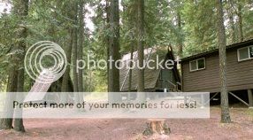
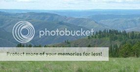
The park features teepees and small cabins for rent, 20 wooded, standard campsites, restrooms with flush toilets and showers, a dump station, a hiking/ski shelter located at the top of Puffer Butte and covered picnic shelters. Fields Springs also offers two group lodges, Puffer Butte and Wo-He-Lo. Each features fireplaces, kitchen and bathroom facilities. Puffer Butte is situated at an elevation of 4,550 feet and offers panoramic views of the northern end of Hells Canyon, the Wallowa Mountains and the Grand Ronde River.
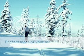
Park hours for Fields Spring is, Summer: 6:30 a.m. to dusk. Winter: 8 a.m. to dusk. If you are camping the hours are, Check-in time, 2:30 p.m. Check-out time, 1 p.m. Quiet hours: 10 p.m. to 6:30 a.m. The park is open year round for camping and day use. A Sno-Park permit is needed from Nov. 15 through April 30. The Fields Spring area has 5 miles of groomed cross country ski trails.
Cache description: First go to the parking coordinates and from there take a nice walk to N46 04.217 W117 10.239 and from there go off of the trail to the first location. There you will find a small container with the coordinates to the final. From here back to the main trail and then to the final will be about .38 miles. You will see spectacular views and please respect the area. Please do not climb on the old corral and also no need to climb any fences.
History: This volcanically originated park was named after Mr. Fields, an early settler who developed a spring used by himself and neighboring settlers. In 1881 Ben and Mary Fields moved to the Anatone area and had created a ranch of 480 acres. It bordered on the east side of what was to later be Fields Spring State Park. They worked hard developing the farmstead. erecting buildings, corrals and fences. They put together orchards and a garden as well as farming and the raising of cattle and horses. Water wasn't to plentiful near the ranch headquarters so he took his team and livestock to adjoining state owned school section. This is to be known as "Fields Spring". The park is set along one of the Nez Perce Indian seasonal migration routes.
Puffer Butte was named for Mr. and Mrs. Puffer, homesteaders who every morning climbed the neighboring Peterson Butte to watch for Indians passing in the canyon below. If Indians were spotted, the Puffers moved their livestock to the top of Puffer Butte and left them there until the Indians passed through. When Mr. and Mrs. A. J. Puffer settled south of Anatone in late 1877, it was at the time of indian unrest. Although the Nez Perce Indians didn't bother them much, especially when that war ended, the Bannocks and Umatillas were on the warpath to the south and west and caused considerable tension. The Puffers lived in their log cabin on the breaks of the Grand Ronde Canyon at the lower slopes of what was later known to be Puffer's Butte. They had fixed their place up by much hard work and had some "blooded" cattle and were reluctant to leave them. So at night they would camp out and before returning in the morning would climb up on the butte to be sure it was safe to return home. The name of the butte, the youth group camp, and the Puffer Butte Environmental Learning Center are named in their honor. Even though the Puffers were in Asotin County a few years, they showed their determination in establishing a home and farm in the wilderness. They will be remembered by the butte and other park facilities that bear the Puffer names.

|
- This geocache has an approved Permit to be placed at this location on property managed by the Washington State Parks and Recreation Commission. Visitors are responsible for acquainting themselves with policies and rules pertaining to State Parks areas.
- The following items may not be placed in the geocache: food, illegal substances, medications, personal hygiene products, pornographic materials, hazardous materials, or weapons of any type.
- By searching for the cache, visitors agree that they are responsible for their own actions, and acknowledge that neither the State of Washington nor the cache owner is responsible for any loss or injury that may occur in relation to such search.
- Report any incident, problem, or violation to State Parks staff.
|