You'll want to fairly careful with the custom container, which contains the log sheet and a short pencil. Replace with care. Stealth needed at this busy spot. Relocated from 6.4 miles away.
This map overlay from the NSHS shows the established rails in 1874.

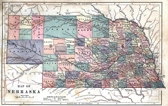
This map from 1887 features a Cheyenne County larger than Cherry County. What is now Thurston County is still the Omaha reservation. Of interest to those who use GPS: along the top of the map, longitude is marked in the standard format, from Greenwich zero. But along the bottom, longitude is marked as degrees from Washington DC! How could that be useful? If nothing else it indicates a lingering migration west.
Modern eyes have to adjust to the two highlighted transport references: rivers and railroads. No need to use font size to display a population difference between Omaha and, say, Fairbury or McCook.
 The Cowboy Recreation and Nature Trail from Norfolk to Chadron is being developed now, but of course in some ways it’s been there for 125 years.
Sources: Nebraska Game & Parks, Library of Congress, NebraskaStudies, Nebraska Department of Roads
The maps and charts used are either with publishing dates before 1922, public government maps from the official census, or data charts of my own design.
For the truly map-obsessed, there's information about the map sources (and tools used to create the new maps) at the WBs geocaching blog. Use the "Related Web Page" link above.