Skip to content

Map Geek 01: Down for the Counties Traditional Geocache

This cache has been archived.

The WBs: Time to give up this spot on the map.

More
Hidden : 5/7/2013
Difficulty:
1.5 out of 5
Terrain:
1 out of 5

Size: Size:   small (small)

Join now to view geocache location details. It's free!

Watch

How Geocaching Works

Related Web Page

Please note Use of geocaching.com services is subject to the terms and conditions in our disclaimer.

Geocache Description:

The Map Geek series of geocaches is for all my fellow map nerds in the caching community. All will (hopefully) have fun finding the cache. Those of you who find the map oddities and fun facts appealing, please feel free to discuss that in your cache log, adding comments, corrections and opinions as you wish.

The container (a baby bottle tube) is hidden a few feet from the county line. Those keeping track of their counties should be able to discern which county contains the cache by checking their surroundings.

There is a bit of parking (NOT on the trail side), but bikes would be great here. Park carefully and watch the road.


The county map of 1859 displays established Nebraska counties as well as the expanse of open land to the west, 8 years prior to statehood. The Homestead Act was passed three years later.  This is before the 1865 raids along the Oregon Trail in Nebraska involving the Sioux, Arapaho and Cheyenne tribes. The Battle of Little Bighorn between Crazy Horse and George Armstrong Custer was 17 years later, and the Wounded Knee massacre didn’t take place until 1890. Parts of Dawson and Buffalo counties as shown here would eventually become part of a county named after Custer, while the upper northwestern corner would have a county named for the Sioux nation that included the Oglala Lakota warrior Crazy Horse. Camp Sheridan is marked where Sheridan county would eventually be. The map also reflects the importance of the web of rivers and tributaries in mid-19th-century Nebraska life.


An overlay of this 1859 map over one from 1887 indicates the rapid settlement and statehood:


There are now 93 Nebraska counties; Garden County was the last to be created, in 1910. The familiar license plate prefixes, ranked 1 through 93 statewide (until the increased population made their use impractical in a few counties) were established in 1922. (It was reported years ago in the Omaha World-Herald that a plan to print county names on license plates was shelved after Hooker county residents objected to displaying “Nebraska / Hooker” on their cars. They have the last prefix, 93.)


14 of the 93 counties were named after Civil War era generals and political figures. Considering that most were named between 1854 and 1888, they are a reflection of the war’s impact.


Origins of County Names:

US Presidents: Adams, Arthur, Fillmore, Garfield, Grant, Hayes, Jefferson, Lincoln, Madison*, Pierce, Polk, Washington (12)

US Vice Presidents and presidential candidates (excludes those who became president): Blaine, Clay, Colfax, Douglas, (Richard Mentor) Johnson (5)

Nebraska territorial or state governors:  Boyd, Burt, Dawes, Furnas, Nance, Richardson, Saunders, Thayer (8)

Native Tribes / Tribal Branches: Cheyenne, Dakota, Otoe, Pawnee, Sioux (5)

Native Tribal Words: Keya Paha (Wakpa) (“turtle hill river”), Nemaha (“miry water”) (2)

Other Notable Americans: (Horace) Greeley, (Daniel) Boone, (Benjamin) Franklin, (Alexander) Hamilton, (Daniel) Webster, (William) Butler, (Lewis) Cass, (Samuel) Cherry, (Augustus) Hall, (Joseph) Holt, (Henry) Knox, (“Mad Anthony”) Wayne (12)

Early Settler Families: Brown, Deuel, Dixon (3)

Other Notable Nebraskans: Chase, Cuming, Dawson, Dundy, Gage, Gosper, Harlan, Hitchcock, Keith, Kimball, Morrill, Nuckolls, Phelps, Sarpy, Thurston, Wheeler (16)

French Words: Loup (“wolf”), Platte (“flat”) (2)

Bodies of water, geological, botanical or zoological attributes, descriptions: Antelope, Banner, Box Butte, Buffalo, Cedar, Frontier, Garden, Loup, Platte, Red Willow, Rock, Saline**, Scotts Bluff, Valley (14)

Civil War notables: George Armstrong Custer, Augustus Caesar Dodge, Stephen A. Douglas, Ulysses Simpson Grant, Joseph Hooker, Oliver Otis Howard, Abraham Lincoln, John Alexander Logan, James Birdseye McPherson, William Henry Seward, Philip Henry Sheridan, William Tecumseh Sherman, Edwin McMasters Stanton, George Henry Thomas (14)

Other places: Fort Kearny, Lancaster (Pennsylvania/England), Madison, Wisconsin*, York (Pennsylvania/England) (4)

A Politician’s Wife: Elvira Merrick, wife of Henry DePuy

Railroad Big Shot: Charles Perkins


*Historians are divided about whether Madison County was named after the president or the city where many of its settlers were from. The Madison County government site favors the Wisconsin story.

**The early settlers’ hopes of a large salt deposit turned out to be misguided, and Saline County is no saltier than its neighboring counties.


Fun facts:

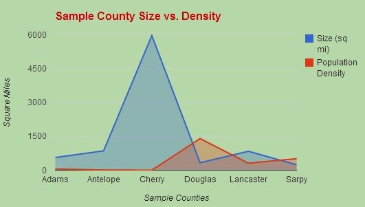
- Cherry County, at nearly six thousand square miles, is one of the largest counties in the US. Its population density is 1 person per square mile. (The population density in Douglas County is 1,401 persons per square mile.) One of only a few US counties to include 2 different time zones, Cherry County is larger than three US states, Connecticut, Delaware and Rhode Island.


- 7 counties were established in 1867, the year of Nebraska statehood: Adams, Cheyenne, Franklin, Hamilton, Saline, Wayne, Webster.

- Greene County, as shown on the 1859 map, was renamed Seward County after Army Gen. Greene joined the confederacy. Nebraska was fairly solidly anti-secessionist, and the territorial legislature had overridden the governor’s veto regarding slavery.

- Knox County was originally named L’Eau Qui Court County, then Emmet County, then Knox.

- Only one county, Merrick, is named after a woman.

- Two men who gave their names to Nebraska counties, Stephen Douglas and Abraham Lincoln, were considered lifelong rivals. John Adams and Alexander Hamilton were also bitter enemies, yet each have a Nebraska county named after them.


Sources: Nebraska State Historical Society, Cherry, Madison  and Saline County websites, US Census, Omaha World-Herald, Wikipedia

The maps and charts used are either with publishing dates before 1922, public government maps including census information, or data charts of my own design.


For the truly map-obsessed, there's information about the map sources (and tools used to create the new maps) at the WBs geocaching blog. Use the "Related Web Page" link above.

Additional Hints (No hints available.)