Ancylusjärven ranta, Aulanko EarthCache
Ancylusjärven ranta, Aulanko
-
Difficulty:
-

-
Terrain:
-
Size:  (not chosen)
Please note Use of geocaching.com services is subject to the terms and conditions
in our disclaimer.
(FIN) Earthcache vanhalla järvenrannalla Aulangon puistometsän reunalla.
(ENG) Earthcache at old beach near Aulanko Park forest.
 tämä on Earthcache joten et löydä paikalta kätkölaatikkoa tai logikirjaa tähän kätköön liittyen.
Tällä Eartcachella käynti osoitetaan suorittamalla kätkökuvauksessa kerrotut tehtävät.
Eartcacheen eli maakätköön kuuluu oleellisena osana kohteen geologiaan liittyvä opetuksellisuus.
 This is an Earthcache so you won't find any items, box, physical cache or logbook at this site.
you can log you visit by doing given tasks.
Each EarthCache provides educational notes about current place geology.
 Ancylusjärven ranta, Aulanko; GC4AY4D
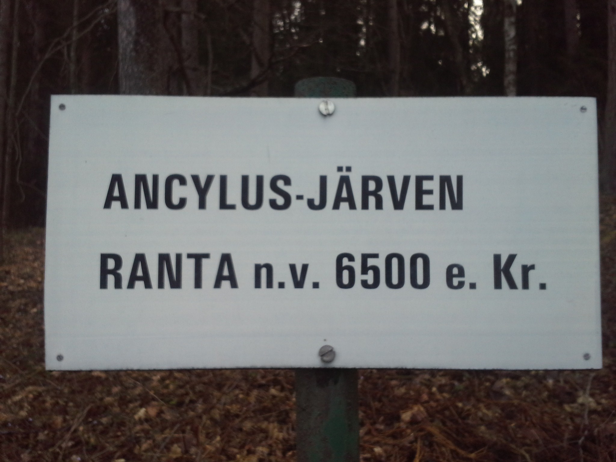
Ancylusjärven rantaviiva Aulangolla
(skip to English section.)
Nykyisin tunnetun Aulangon historia alkaa vuodesta 1883, mutta paikalla on myös paljon kauemmaksi ulottuvat juurensa. Alueelta on löydettävissä itämeren kehitysvaiheisiin liittyvien Yoldiameren sekä Ancylusjärven rantaviivat. Aulangonvuoren huippu on Suomen maaperän ensimmäisiä esille nousseita pisteitä jääkauden jälkeisenä aikana.
Yoldiameri (ääntyy Joldiameri) oli nykyisen Itämeren varhaisvaihe, joka syntyi noin 11 600 vuotta sitten, kun Baltian jääjärvi yhdistyi Atlanttiin Keski-Ruotsin poikki syntyneen salmen kautta jäätikön vetäytyessä alueelta pohjoiseen (piirros1). Yoldiameri on saanut nimensä tuon ajan kerrostumista Keski-Ruotsissa löydetyn kylmän suolaisen veden Yoldia arctica -simpukan mukaan.
(hyppää piirroksiin).
Yoldiavaiheen alussa laaja mannerjäätikkö peitti vielä Suomea. Jäätikön raja oli alussa Etelä-Suomessa salpausselkävyöhykkeessä. Kolmas Salpausselkä ja Sisä-Suomen reunamoreenit syntyivät Itämeren Yoldiavaiheessa.
Yoldiameren syntyessä Baltian jääjärven (piirros, 1 a)) pinta laski äkkiä noin 25 metriä. Atlanttiin yhdistävä salmi oli nykyisessä Närken maakunnassa Ruotsin nykyisten suurten järvien seuduilla, Billingenin vuoren pohjoispuolella. Tätä kautta virtasi ensin makeaa vettä valtamereen ja myöhemmin suolaista vettä Yoldiamereen. Suolainen vesi ehti Suomen rannikolle vasta 300 vuotta salmien avautumisen jälkeen. Jään painamana maanpinta Keski-Ruotsissa, samoin kuin Suomessa, oli silloin nykyistä alempana. Vaikka valtameren pintakin oli vielä nykyistä alempana, rantaviivan suhteellinen taso Itämeren pohjoisosissa oli 100-180 metriä nykyistä rantaa korkeammalla. Etelässä maa ei ollut vastaavasti painunut, ja Tanskan salmet olivat kuivilla. Yoldiameren (p1,b) suolapitoisuus väheni Närken salmen kaventuessa ja madaltuessa maankohoamisen takia huomattavan nopeasti; maa kohosi silloin paljon nopeammin kuin nyt. Yoldiameri oli siis alussa makeavetinen, keskivaiheilla murtovettä ja loppuvaiheessa makeavetinen.
Maankohoaminen eli isostasia tarkoittaa maan hyvin hidasta kohoamista. Tämä johtuu Suomessa viimeisestä jääkaudesta, jolloin jäätikkö painoi maankuoren lommolleen (piirros2 ja piirros3). Jäätikön aiheuttama maankuoren lommolleen painuminen on havaittavissa nykyään Etelämantereen ja Grönlannin jäätiköistä. Kun jäätikkö on sulanut, lommo pyrkii hitaasti oikenemaan (piirros 2 b)). Kun maa kohoaa vesistön rannan lähellä, kuivaa maata ilmestyy, saaret kasvavat ja merestä ilmestyy uusia saaria. Suomessa maan kohoaminen näkyy tällä hetkellä selvimmin muun muassa Vaasan seuduilla Merenkurkun rannoilla.
Ancylusjärvi syntyi, kun Yoldiameren yhteys Atlanttiin katkesi keskiruotsissa etenevän maankohoamisen takia. Ancylusjärvi (p1,c) peitti monia nykyisen Länsi- ja Etelä-Suomen alueita, ja veden pinta oli alussa huomattavan korkealla etenkin pohjoisessa. Aluksi Ancylusjärven laskujoki, Sveajoki, sijaitsi Keski-Ruotsissa Vänernin ja Vätternin tienoilla. Samassa kohdassa oli aikaisemmin oli ollut Yoldianmeren Atlanttiin yhdistänyt Närkensalmi. Kun jääkauden jälkeinen maankohoaminen oli suurempi pohjoisessa kuin etelässä, järvi kallistui vähitellen etelään, mistä seurasi että laskujoki siirtyi nykyisen Juutinrauman ja Ison-Beltin kohdalle. Kun jäätiköt vähitellen sulivat myös Fennoskandian pohjoisosista sekä Pohjois-Amerikasta, Atlantin pinta nousi, ja lopulta Ancylusjärven laskujoen paikalle lopulta syntyivät nykyiset Tanskan salmet. Tällöin Ancylusjärvi muuttui Litorinamereksi (p1,d).
Jotta voit merkitä logatuksi tämän kätkön sinun
täytyy suorittaa seuraavat tehtävät annetuissa koordinaateissa:
1 )
annetuissa Koordinaateissa N 61° 01.015 E 024° 27.130 (boguspiste) on merkitty muinasen Ancylusjärven rantaviiva a) Arvioi muinaisen Ancylusjärven rantaviivan korkeusero nykyisestä merenpinnasta.
b) Kerro mitä sellaista paikalla on havaittavissa, joka kertoo että tässä on sijainnut vanha järvenranta?
c) Miksi nykyinen Itämeren ranta sijaitsee niin kaukana tältä pisteeltä?
d) Kuinka muinanen Ancylusjärvi ja nykyinen Vanaja järvi liittyvät toisiinsa?
2 )
Koordinaateissa N 61° 01.357 E 024° 28.094 (waypoint) on merkittynä muinaisen Yoaldiameren rantaviiva.
a) Mikä on näiden kahden itämeren kehitysvaiheisiin liittyvän rantaviivan korkeusero nykyään? (käytä apuna esim GPS laitteesi kokeusmittaria)
b) Mikä oli merkittävin ero Ancylusjärven ja Yoldiameren välillä? (biologisesti ja geologisesti)
c) Miksi ja miten rannat eroavat nyt toisistaan (korkeus / jyrkkyys / korkeus nykyisestä merenpinnasta tms)?
3 )
vapaaehtoinen tehtävä: "selvitä Mistä Ancylusjärvi on saanut nimensä?"
4 )
Lähetä vastauksesi kätkön omistajalle vaikkapa tällä viestilinkillä.
Kirjoita viestin otsikoksi Ancylusjärven ranta, Aulanko
(ps. jos valitset viestin alta "I want to send my email address along with this message" vastaamiseni helpottuu)
5 )
Sinun ei tarvitse odottaa loggauslupaa, mutta asiattomat logit tullaan poistamaan. Omistaja vastaa jollain aikavälillä viestiin, jos vastauksissa on epäselvää.
6 )
Toivottavaa mutta ei pakollista on myös että otat valokuvan itsestäsi ja/tai gps laitteestasi Ancylusjärven rantaviivalla ja liität se logiisi.
![]()
Lake Ancylus beach at Aulanko
today, Well-known history of Aulanko goes back to 1883, but the geology of the place goes much further. You can find couple of old shorelines related to progression of the Baltic basin at the area. Near the castle mountain you can find old coastline of Yoldiasea and att this site you can see beach of the ancient lake Ancylus dating from approximately 6500 BC. Aulanko mountain peak is one of the first Finnish soil, which came up at the period following the last Ice Age.
progression of the Baltic basin:
The Baltic Ice Lake, the Yoldia Sea, the Ancylus Lake and the Littorina Sea are four recognized stages in the postglacial progression of the Baltic basin (Drawing1) – there are also transition periods which can be considered as substages.
(skip to drawings).
The Baltic Ice Lake (drawing 1,a) came to an end when it overflowed through central Sweden and drained, a process complete by about 10,300 BP (radiocarbon years). The straits through the present Stockholm region (via Lake Vänern and the Strait of Närke) to the Atlantic were the only outlet at that time. When lake level reached see level the difference in salinity caused a backflow from the North Sea, creating saline. This phase lasted until about 10,000 BP.
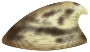
Yoldia Sea is a name given by geologists to a variable brackish-water stage in the Baltic Sea basin that prevailed after the Baltic ice lake was drained to sea level during the Weichsel glaciation. Dates for the Yoldia sea (d1,b) are obtained mainly by radiocarbon dating material from ancient sediments and shore lines and from clay-varve chronology. They tend to vary by as much as a thousand years, but a good estimate is 10,300 – 9500 radiocarbon years BP, equivalent to ca 11,700-10,700 calendar years BP. The name of the sea is adapted from the obsolete name of the bivalve, Portlandia arctica (previously known as Yoldia arctica), found around Stockholm. This bivalve requires cold saline water. It characterizes the middle phase of the Yoldia Sea, during which saline water poured into the Baltic, before the acceleration of glacial melting.
Subsequently, increased melting of the glacier provided additional fresh water and the lake became stratified (meromictic), with salt water on the bottom and fresh on top. Over the life of the sea and from location to location the salinity was a variable. Whether it is possible to speak of stages of salinity that would apply uniformly to the whole sea is debatable.
When the ice retreated from Fennoscandia more than 10,000 years ago, the Earth's crust was depressed half a kilometre due to the weight of the ice which was 2 kilometres thick . When the ice melted, the crust began to rise, and the recovery still continues (drawing2 and drawing3). This is called isostatic reboun. Near the Gulf of Bothnia, where the ice was thickest, the current uplift rate is about 2 centimetre per year, and there is still some 100 meters to rise.Geographically, the Gulf of Bothnia remained under the ice during Yoldiasea era. The Gulf of Finland was open but most of Finland was an archipelago, over which debris carried by glacial streams gradually spread. A land bridge joined Germany to southern Sweden through Denmark. Relieved of its weight of ice, Finland rose gradually and unevenly from the sea. Parts of the Yoldia shoreline are above sea level today while other parts remain below.
At about 10,000 BP, the exit continued to rise and the sea broke through Denmark creating the first Great Belt channels. The total opening was less than 1 km wide and included two channels at the northern end. The Great Belt channels was blocked again by rising land from the post-glacial rebound In Sweden and that created Ancylus Lake (d1,c). The elevation of southern Sweden did not entirely block the flow across central Sweden. Some egress continued from the lake through the Göta and Steinselva rivers, which exit Lake Vänern to the Kattegat. Salt water did not enter the lake, however, which became entirely fresh as the lake rose above sea level. The date at which the flow was certainly blocked is about 8000 BP, when nearby Lake Vättern (part of the waterway system) became dissevered from Ancylus lake.
The result of increasing lake levels was the Ancylus transgression, a general flooding around its shores, 9500–9200 BP. By this time a somewhat larger Gulf of Bothnia and parts of Norway were free of ice, while the Rovaniemi region of Finland appeared no later than 9000 BP, despite the new flooding
By 9200 BP the Anculys lake rose over the Dars sill and cut a new channel in the vicinity of what is now the "Great Belt" (the channel between the Danish islands Zealand and Funen), which some geologists call the Dana River. For a time, Skåne, or southern Sweden, was an island once more, from about 9200 to no later than 8000 BP. This stage of the baltic sea is called Litorina Sea (d1,d). At this period of time the sea level began to drop.
To log this cache you must do following tasks in given coordinates:
1 )
Old Lake Ancylus beach is marked at the coordinates N 61° 01.015 E 024° 27.130 (pogus point). Area above this shoreline has been untouched by the water during Lake Ancylus era.
a) Find out how much lower is the sealevel of baltic sea at this spot today?
b) Explain what there is on the site that you can see that tells you that this has been in an old beach?
c) Why is the present Baltic sea shoreline so far away from this point?
d) How are ancient Anclyluslake and present lake Vanaja related to each other?
2 )
At the coordinates N 61° 01.357 E 024° 28.094 (waypoint) you can find the shoreline of Yoldia sea.
a) Measure the height difference between these two shorelines using your gps device.
b) How does these two shorelines differ from each other and why? (steepnes, height, level from current sealevel etc.)
c) What was the biggest difference between Lake Ancylus and Yoldia sea?
3 )
optional task: "From what has the Lake Ancylus got its name?"
4 )
Send your answers (for example via this message link) to the cache owner.
Title your post “Ancylusjärven ranta, Aulanko”
(ps. if you enable selction "I want to send my email address along with this message" it is easier for me to reply)
5 )
You don't have to wait for a logging permission, but any incomplete logs will be deleted. Cache owner will reply something for post if there is some faults in answers.
6 )
Is also desirable altough totally optional that you take a photo of yourself and/or your GPS device on the old Lake Anculys shoreline and attach it to you log.
![]()
Piirrokset
Drawings
piirros 1,Drawing1: Progression of the Baltic basin:

a) Baltic Ice lake b) the Yoldia sea
c) the Ancylus Lake d) the Littorina Sea
käännös:
sea whit salt water = suolaisen veden meri
lake whit fresh water = makean veden järvi
frontier of the icecaps = jäätikön reuna
a) Baltian jääjärvi b) Yoldiameri
c) Ancylusjärvi d) Litorinameri
piirros 2, Drawing 2: uplfit of the land:
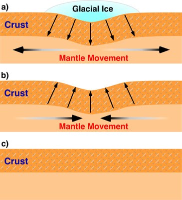
a) Clacier pressing down crust
b) isostatic rebound
c) normal crust
käännös:
Glacial ice=jäätikkö, crust=kuori, mantle=vaippa
a) Jäätikkö painaa maankuoren lommolle
b) kuori palautuu jään sulaessa, maankohoaminen eli isostasia
c) normaali maankuori
piirros 3, Drawing 3: uplfiting of the land in Scandinavia:
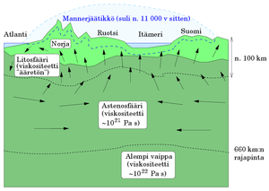
Norja=Norway, Ruotsi=Sweden, Itämeri=Baltic sea, Suomi=FInland
mannerjäätikkö=Glacial ice
Additional Hints
(No hints available.)