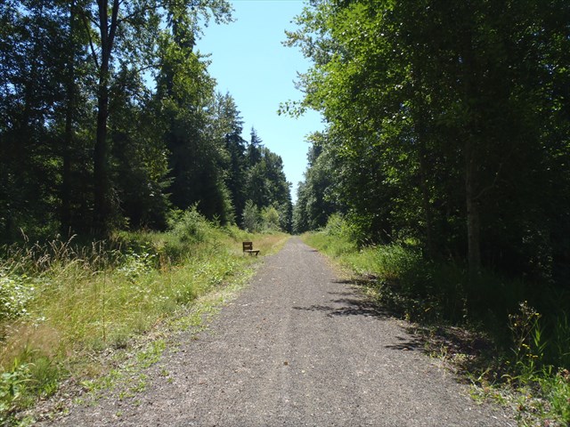
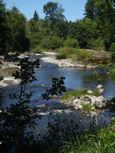
A cache placement along the old Northern Pacific railroad corridor now referred to as the Willapa Hills State Trail from Chehalis to South Bend. It all started back in early 1990’s when Washington State Parks began acquiring the right-of-way. This is an easy cache to walk to, about 1 mile round trip. Along the way and at a cache location, there are beautiful views of the Chehalis river.
The Willapa Hills State Trail stretches 56 miles from Chehalis to South Bend along Highway 6, rambling through pastoral valleys to the tidewater at Willapa Bay. Many stretches of the trail lead away from the highway. You get a distinct feeling that only those few railroad employees and passengers ever set eyes upon these lands. Only certain sections are paved or re-graveled. Plans do call for surface improvements, parking areas, and the addition of primitive campsites. The majority of the remote bridges are accessible but not advised due to flood and maintenance issues. The brush has been kept in check over most of the distance. The terrain is nearly flat, within the standard 2% grade. Parts of the trail are wheelchair accessible and most users can travel long sections of the trail without experiencing difficulties. There are 31 railroad bridges of which 4 washed out or damaged in the '07 floods and are in the process of being replaced. They range in length from 40’ to 823’. Less than half are planked and graveled, evenly spilt between Lewis and Pacific counties. Several roads, including private ones bisect the trail. There are many access points along the journey, many have adequate and legal parking.
Bear in mind that this is a very lightly traveled section of the state, but that adds to the appeal of the trail. The Chehalis end is just south of the Highway 6 interchange with I-5 (exit 77).
This link will be helpful in finding additional information about the Lewis County section of the trail
Please Note:
Some bridges along the Willapa Hills Trail are closed until further notice due to extensive flooding damage in Dec. 2007. Please be aware that portions of the trail are inaccessible as a result of these closures.
Driving Instructions:
Option one.
Closest access from new steel bridge (2017). Use new waypoint coordinates.
1) Exit 77 (I-5)
2) Route 6 for 13 - 14 miles and use New Steel Bridge coordinates to cross the Chehalis
3) Right onto Leudinghaus for another .75 miles
4) Park in lot adjacent to the trail per parking coordinates
5) After returning to parking, drive 2.90 miles to the Park entrance and visit the Rainbow Falls Park cache
Driving Instructions: (Decided to add since all the nearby bridges crossing the Chehalis washed out in '07 and some mapping software may not have been updated)
Option two.
1. From I-5, travel approximately 16 miles
2) Turn onto Chandler for .25 miles
3) Turn right onto Leudinghaus Rd. for 4 miles, passing the Rainbow Falls Park entrance
4) Turn into parking area on the right per coordinates

|
- This geocache has an approved Permit to be placed at this location on property managed by the Washington State Parks and Recreation Commission. Visitors are responsible for acquainting themselves with policies and rules pertaining to State Parks areas.
- The following items may not be placed in the geocache: food, illegal substances, medications, personal hygiene products, pornographic materials, hazardous materials, or weapons of any type.
- By searching for the cache, visitors agree that they are responsible for their own actions, and acknowledge that neither the State of Washington nor the cache owner is responsible for any loss or injury that may occur in relation to such search.
- Report any incident, problem, or violation to State Parks staff.
|